Bewdley
| Bewdley (including Wribbenhall) | |
|---|---|
 Load Street | |
 Bewdley (including Wribbenhall) Bewdley (including Wribbenhall) shown within Worcestershire | |
| Population | 9,470 (2001) |
| OS grid reference | SO785752 |
| • London | 134.2 miles |
| Civil parish |
|
| District | |
| Shire county | |
| Region | |
| Country | England |
| Sovereign state | United Kingdom |
| Post town | Bewdley |
| Postcode district | DY12 |
| Dialling code | 01299 |
| Police | West Mercia |
| Fire | Hereford and Worcester |
| Ambulance | West Midlands |
| EU Parliament | West Midlands |
| UK Parliament | |
Bewdley (![]()
Town geography

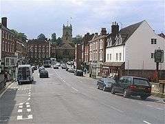
The main part of Bewdley town is situated on the western bank of the River Severn, including the main street—Load Street—whose name derives from lode, an old word for ferry. Load Street is notable for its width: this is because it once also served as the town's market place. Most of Bewdley's shops and amenities are situated along Load Street, at the top of which lies St Anne's Church, built between 1745 and 1748 by Doctor Thomas Woodward of Chipping Campden.
Beyond the church, High Street leads off to the south towards Stourport along the B4194, a road known locally as "the switchback" because of its many undulations. Unlike in many English towns, High Street is so called not because of its importance, but because of its geographical position 'high' above the river.
On the other side of the church, Welch Gate (so called because it once contained a tollgate on the road towards Wales) climbs steeply up to the west, while a continuation of the B4194 leads northwest towards the Wyre Forest. To the northeast of the town is the wooded hilltop of Wassel Wood in Trimpley, the southern terminus of Shatterford Hill.
In the area between Stourport and Bewdley there are several large country houses, among which Witley Court, Astley Hall and Pool House are particularly significant.
History and government
Mesolithic period settlers have been identified through excavations in Wribbenhall, which found 1,400 fragments of flint tools, as well as post holes, a hearth, gullies and a pit. This site has been dated to roughly 6,800 BC, making it the oldest settlement yet identified in Worcestershire. Pollen evidence shows that crops were already being grown and woodlands cleared at this time.[4]
The settlement of Wribbenhall, on the eastern side of the Severn, and now part of Bewdley, was recorded in the Domesday Book as being part of the manor of Kidderminster. By the 14th century, the town had come to be known as Beau lieu, French for "Beautiful place" - a compliment that fits well with John Leland's statement in his Itinerary two centuries later that "a man cannot wish to see a towne better".
Bewdley was granted borough status, as well as a weekly market, by King Edward IV in 1472, and retained this status until local government reorganisation in 1974. A parliamentary report of 1777 listed Bewdley as having a parish workhouse accommodating up to 80 inmates.
During the Second World War, Ribbesford House in Bewdley was used as the headquarters for the Free French officer cadets. The cadets consisted of 200 teenagers who undertook military training at Ribbesford House until they joined with other allied forces in the D Day invasion.[5]
Bewdley is now governed by three tiers of local government; in increasing order of size: Bewdley town council, Wyre Forest district council and Worcestershire county council.
For many centuries Bewdley had its own Member of Parliament (MP), most famously the Conservative Prime Minister Stanley Baldwin who represented it from 1908–1937, but in 1950 the Bewdley constituency was abolished and the town was included in the Kidderminster constituency. In 1983, the Kidderminster constituency itself was absorbed into the Wyre Forest constituency, which currently encompasses all of Bewdley. The MP for Wyre Forest is Mark Garnier of the Conservative Party, who in 2010 unseated the incumbent, Richard Taylor of Independent Kidderminster Hospital and Health Concern (often simply Health Concern), a local organisation. The Labour Party held the seat from 1997-2001.
The former quayside on the western bank of the river has been much prettified and landscaped over the last few decades, and its rows of Georgian townhouses and buildings are well seen from Telford's bridge. Since the completion of the flood defences in 2006 (see below), a "Civic Space" has been introduced to replace the old bandstand. It is used on a variety of occasions including the twice monthly Bewdley Riverside Market.
River and bridges
The River Severn often used to burst its banks in winter, flooding many houses and commercial premises in Bewdley. However, after the 2000 floods, plans were made for flood defences on the western bank, and this work was completed in April 2006, costing £7 million.[6] Temporary barriers are also put up to protect properties on the Eastern side of the river in Wribbenhall. Among the worst floods in living memory were those in 1947, 1968 and 2000, where 140 properties were affected.[6] Bewdley's long experience of dealing with flooding led to the setting up of the National Flood Forum in the town in 2002.
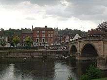
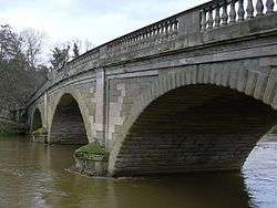
Bewdley Bridge over the Severn was built in 1798 by Thomas Telford. It was erected to replace the 1483 medieval bridge which was swept away in the floods of 1795.
A modern road bridge, opened to the south-east of the town at Blackstone in 1987 after many decades of campaigning, carries the Bewdley bypass across the river.
The Tenbury and Bewdley Railway branched off Severn Valley Railway at Bewdley, and ran through the Wyre Forest to Tenbury Wells. It crossed the river at Dowles, a little to the north of Bewdley. The bridge itself no longer exists, although its imposing brick and stone pillars remain.
Education
There are three state schools in Bewdley. Of these, two are primary schools: St Anne's CE Primary on the west side of town and Bewdley Primary School in Wribbenhall on the eastern side of the Severn. The single secondary school is The Bewdley School. The Bewdley Grammar School on Lax Lane closed in the 1800s. Since then, the former grammar school is now home to many art galleries and art and craft activities. After the closure of Bewdley Grammar School, Bewdley High School & Sixth Form Centre was built on the opposite side of the river with new buildings. In 2007, Bewdley High School closed after 54 years due to an educational tier change, with all high schools being replaced by new secondary schools.[7]
In 2007, after new constructs, landscaping, building refurbishments and extensions, The Bewdley School opened as a new secondary school, with extensive new facilities for the arts and outdoor learning. The Bewdley Sixth Form is also part of The Bewdley School, collectively offering GCSE and A Level courses. The Bewdley School is consistently high performing at GCSE and A-Level and attracts students from outside of the catchment area. [8] [9] [10] [11].
Local attractions
Events
The Bewdley Festival, featuring a variety of artistic performances, is held in the town each October, and Bewdley also hosts one of the largest inland river regattas in the country. The Bewdley Beer Festival is held each August Bank Holiday weekend. Bewdley also has a carnival which takes place every June.
Country music scene and festivals
Bewdley has a distinguished music scene, and is particularly well known for its intimate country music venues and its many local festivals including Hop Fest, Bewdley music festival, Arley festival and Bewdley Live.[12][13] Former Led Zeppelin lead- and now solo singer Robert Plant lives in the nearby village of Upper Arley, and has been known to perform in the River Rooms; a small, intimate country music venue above the Cock and Magpie pub on the north riverside. The River Rooms attract country, soul, rock, jazz and pop performers from all cross Europe and North America.[14] Bewdley remains a significant centre for country music within the United Kingdom.[15]
Other amenities
The West Midland Safari Park is just out of the town, on the A456 towards Kidderminster.
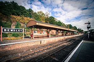
Bewdley was, until an office move in 2014 to Kidderminster, the headquarters of the Severn Valley Railway, a heritage railway running the 16 miles between Kidderminster and Bridgnorth. Bewdley remains the principal intermediate station on the line.
The Queen Elizabeth II Jubilee Gardens (usually abbreviated to simply "Jubilee Gardens") are between the Bewdley Museum and the River Severn.
Bewdley is on the southeastern edge the Wyre Forest, and there are many footpaths and cycle routes through the woodlands. There is a visitor centre situated just outside Bewdley at Callow Hill on the road to Cleobury Mortimer, where many waymarked trails through the forest start from.
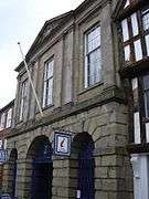
The Bewdley museum (admission free), housed in the Guildhall (alongside the Tourist Information Centre) explores the history of the town and has displays on local crafts such as coopering, basket making, agriculture, charcoal burning and tanning. It also stages occasional small exhibitions by contemporary local artists.
Just outside Bewdley is Beau Castle, a Victorian mock-Gothic house, built in 1877. It was developed by the industrialist and former Mayor of Birmingham and Bewdley, George Baker. Beau Castle was designed by John Ruskin and Richard Doubleday with stained-glass windows by Edward Burne-Jones.
Notable residents
- Becky Hill, singer
- John Beddoe, ethnologist, was born in Bewdley in 1826[16]
- Brian Turner Tom Lawrence, awarded the Victoria Cross in the Boer War, was born in Bewdley
- Stanley Baldwin, who served as prime minister three times between 1923 and 1937, was born at Lower Park House, Lower Park, in 1867. He served as MP for the town from 1908 for nearly thirty years and later became Earl Baldwin of Bewdley.[17]
- Former Led Zeppelin lead- and now solo singer Robert Plant lives in the nearby village of Upper Arley, and is a member of Bewdley Tennis and Rowing Club(s).
- Alun Evans, footballer, who in 1968 became the most expensive teenage transfer in history, moving from Wolverhampton Wanderers to Liverpool F.C., was born in the town.
- Rustie Lee, TV chef and actress has lived in the town and local area for 20 years
- Alison Mardell, solicitor and senior Royal Air Force officer, born here
- Karl Hyde, musician, best known as a member of British techno/electronic music band Underworld was born in Bewdley.[18]
- Will Holland (Quantic), musician, DJ and record producer is from Bewdley.
- Kayleigh Pearson, model, grew up in Bewdley, and attended Bewdley High School, now The Bewdley School and Sixth Form Centre
Twin towns


References
- ↑ "Birmingham to Bewdley". Google Maps. Retrieved 12 November 2017.
- ↑ "Wyre Forest". UK Census Data. Retrieved 24 January 2015.
- ↑ "Bewdley Bridge". Engineering Timelines. Archived from the original on 10 July 2011. Retrieved 24 January 2010.
- ↑ Pevnser & Brookes 2007, pp. 10-11
- ↑ Upton, Chris (25 September 2009). "The European royalty who found a Midlands home during World War Two". Birmingham Post. Retrieved 3 October 2013.
- 1 2 "Bewdley Case Study: The Bewdley Flood Defence Scheme". Geographical Association. Retrieved 12 November 2017.
- ↑ http://www.kidderminstershuttle.co.uk/news/1554813.Wyre_Forest_schools_shake-up/
- ↑ http://www.kidderminstershuttle.co.uk/news/8350144.Bewdley_School_s_GCSE_results_improve_by_15_/
- ↑ http://www.kidderminstershuttle.co.uk/news/10563371.Bewdley_School_congratulated_by_Nick_Clegg_for_exam_results/
- ↑ http://www.kidderminstershuttle.co.uk/news/13613842.Wyre_Forest_students_celebrate_their_GCSE_results/
- ↑ https://www.bewdley.worcs.sch.uk/about/exam-results
- ↑ "Home". Bewdley Live. Retrieved 12 November 2017.
- ↑ "Hopfest on Fire, Live Music". Hopfest. Retrieved 12 November 2017.
- ↑ "Live music events". The Cock & Magpie, Bewdley. Retrieved 12 November 2017.
- ↑ "Bewdley". Ents24. Retrieved 12 November 2017.
- ↑ James, TE (1912). "Beddoe, John". In Lee, Sidney. Dictionary of National Biography, 1912 supplement. London: Smith, Elder & Co.
|access-date=requires|url=(help) - ↑ "Stanley Baldwin". Archived from the original on 16 December 2011. Retrieved 31 July 2011.
- ↑ Hyde, Karl (2016). I am Dogboy. London: Faber & Faber. p. 5. ISBN 978-0-571-32865-9.
Further reading
- Larkham, Peter J., and John Pendlebury. "Reconstruction planning and the small town in early post‐war Britain." Planning Perspectives 23#3 (2008): 291-321. Case study
- Pevsner, Nikolaus; Brookes, Alan (2007), Worcestershire, The Buildings of England (Revised ed.), London: Yale University Press, ISBN 9780300112986, OL 10319229M