Rittman, Ohio
| Rittman, Ohio | |
|---|---|
| City | |
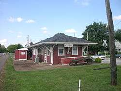 The former Erie Railroad depot in Rittman, now a restaurant. | |
 Location of Rittman, Ohio | |
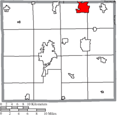 Location of Rittman in Wayne County | |
| Coordinates: 40°58′24″N 81°47′4″W / 40.97333°N 81.78444°WCoordinates: 40°58′24″N 81°47′4″W / 40.97333°N 81.78444°W | |
| Country | United States |
| State | Ohio |
| Counties | Wayne, Medina |
| Government | |
| • Mayor | William J. Robertson |
| Area[1] | |
| • Total | 6.49 sq mi (16.81 km2) |
| • Land | 6.43 sq mi (16.65 km2) |
| • Water | 0.06 sq mi (0.16 km2) |
| Elevation[2] | 981 ft (299 m) |
| Population (2010)[3] | |
| • Total | 6,491 |
| • Estimate (2012[4]) | 6,501 |
| • Density | 1,009.5/sq mi (389.8/km2) |
| Time zone | UTC-5 (Eastern (EST)) |
| • Summer (DST) | UTC-4 (EDT) |
| ZIP code | 44270 |
| Area code(s) | 330 and 234 |
| FIPS code | 39-67356[5] |
| GNIS feature ID | 1061609[2] |
| Website | http://www.rittman.com/ |
Rittman is a city in Medina and Wayne counties in the U.S. state of Ohio. All but a small portion of the city is in Wayne County, within commuting distance of Akron, Canton and Cleveland. The population was 6,491 at the 2010 census.
Geography
Rittman is located at 40°58′24″N 81°47′4″W / 40.97333°N 81.78444°W (40.973376, -81.784416).[6]
According to the United States Census Bureau, the city has a total area of 6.49 square miles (16.81 km2), of which 6.43 square miles (16.65 km2) is land and 0.06 square miles (0.16 km2) is water.[1]
Demographics
| Historical population | |||
|---|---|---|---|
| Census | Pop. | %± | |
| 1920 | 1,803 | — | |
| 1930 | 2,785 | 54.5% | |
| 1940 | 2,770 | −0.5% | |
| 1950 | 3,810 | 37.5% | |
| 1960 | 5,410 | 42.0% | |
| 1970 | 6,308 | 16.6% | |
| 1980 | 6,063 | −3.9% | |
| 1990 | 6,147 | 1.4% | |
| 2000 | 6,314 | 2.7% | |
| 2010 | 6,491 | 2.8% | |
| Est. 2017 | 6,564 | [7] | 1.1% |
| Sources:[8][9][10][5][11] | |||
2010 census
As of the census[3] of 2010, there were 6,491 people, 2,547 households, and 1,763 families residing in the city. The population density was 1,009.5 inhabitants per square mile (389.8/km2). There were 2,752 housing units at an average density of 428.0 per square mile (165.3/km2). The racial makeup of the city was 97.2% White, 0.4% African American, 0.2% Native American, 0.4% Asian, 0.2% from other races, and 1.6% from two or more races. Hispanic or Latino of any race were 1.2% of the population.
There were 2,547 households of which 33.5% had children under the age of 18 living with them, 51.6% were married couples living together, 11.9% had a female householder with no husband present, 5.8% had a male householder with no wife present, and 30.8% were non-families. 26.2% of all households were made up of individuals and 10.8% had someone living alone who was 65 years of age or older. The average household size was 2.52 and the average family size was 3.01.
The median age in the city was 38.5 years. 23.9% of residents were under the age of 18; 8% were between the ages of 18 and 24; 26.9% were from 25 to 44; 26.5% were from 45 to 64; and 14.7% were 65 years of age or older. The gender makeup of the city was 48.9% male and 51.1% female.
2000 census
As of the census[5] of 2000, there were 6,314 people, 2,424 households, and 1,711 families residing in the city. The population density was 1,046.9 people per square mile (404.3/km²). There were 2,518 housing units at an average density of 417.5 per square mile (161.2/km²). The racial makeup of the city was 98.13% White, 0.10% African American, 0.22% Native American, 0.38% Asian, 0.27% from other races, and 0.90% from two or more races. Hispanic or Latino of any race were 0.89% of the population.
There were 2,424 households out of which 34.6% had children under the age of 18 living with them, 55.8% were married couples living together, 10.8% had a female householder with no husband present, and 29.4% were non-families. 25.5% of all households were made up of individuals and 10.8% had someone living alone who was 65 years of age or older. The average household size was 2.57 and the average family size was 3.10.
In the city the population was spread out with 26.5% under the age of 18, 8.2% from 18 to 24, 31.7% from 25 to 44, 20.3% from 45 to 64, and 13.3% who were 65 years of age or older. The median age was 36 years. For every 100 females, there were 95.2 males. For every 100 females age 18 and over, there were 92.1 males.
The median income for a household in the city was $35,020, and the median income for a family was $41,643. Males had a median income of $30,885 versus $23,708 for females. The per capita income for the city was $16,049. About 6.4% of families and 8.3% of the population were below the poverty line, including 11.8% of those under age 18 and 9.2% of those age 65 or over.
Education
Rittman High School, Rittman Middle School, and Rittman Elementary School are all part of the Rittman Exempted Village School District.
Rittman is served by a branch of the Wayne County Public Library.[12]
References
- 1 2 "US Gazetteer files 2010". United States Census Bureau. Archived from the original on 2012-01-24. Retrieved 2013-01-06.
- 1 2 "US Board on Geographic Names". United States Geological Survey. 2007-10-25. Retrieved 2008-01-31.
- 1 2 "American FactFinder". United States Census Bureau. Retrieved 2013-01-06.
- ↑ "Population Estimates". United States Census Bureau. Archived from the original on 2013-06-17. Retrieved 2013-06-17.
- 1 2 3 "American FactFinder". United States Census Bureau. Retrieved 2008-01-31.
- ↑ "US Gazetteer files: 2010, 2000, and 1990". United States Census Bureau. 2011-02-12. Retrieved 2011-04-23.
- ↑ "Population and Housing Unit Estimates". Retrieved May 26, 2018.
- ↑ "Population: Ohio" (PDF). 1930 US Census. U.S. Census Bureau. Retrieved 28 November 2013.
- ↑ "Number of Inhabitants: Ohio" (PDF). 18th Census of the United States. U.S. Census Bureau. Retrieved 22 November 2013.
- ↑ "Ohio: Population and Housing Unit Counts" (PDF). U.S. Census Bureau. Retrieved 22 November 2013.
- ↑ "Incorporated Places and Minor Civil Divisions Datasets: Subcounty Population Estimates: April 1, 2010 to July 1, 2012". U.S. Census Bureau. Archived from the original on 17 June 2013. Retrieved 25 November 2013.
- ↑ "Hours & Contact Information". Wayne County Public Library. Archived from the original on 8 August 2016. Retrieved 10 June 2016.
External links
Municipalities and communities of Medina County, Ohio, United States | ||
|---|---|---|
| Cities | 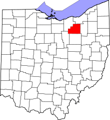 | |
| Villages | ||
| Townships | ||
| Unincorporated communities | ||
| Footnotes | ‡This populated place also has portions in an adjacent county or counties | |
Municipalities and communities of Wayne County, Ohio, United States | ||
|---|---|---|
| Cities |  | |
| Villages | ||
| Townships | ||
| CDPs | ||
| Unincorporated communities | ||
| Footnotes | ‡This populated place also has portions in an adjacent county or counties | |
| Authority control |
|---|