Green Township, Wayne County, Ohio
| Green Township, Wayne County, Ohio | |
|---|---|
| Township | |
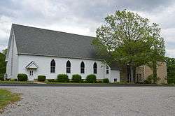 Oak Grove Mennonite Church on Smucker Road | |
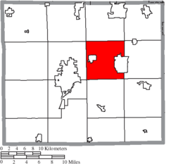 Location of Green Township in Wayne County | |
| Coordinates: 40°50′53″N 81°47′57″W / 40.84806°N 81.79917°WCoordinates: 40°50′53″N 81°47′57″W / 40.84806°N 81.79917°W | |
| Country | United States |
| State | Ohio |
| County | Wayne |
| Area | |
| • Total | 36.0 sq mi (93.3 km2) |
| • Land | 36.0 sq mi (93.2 km2) |
| • Water | 0.0 sq mi (0.0 km2) |
| Elevation[1] | 1,145 ft (349 m) |
| Population (2000) | |
| • Total | 12,194 |
| • Density | 338.7/sq mi (130.8/km2) |
| Time zone | UTC-5 (Eastern (EST)) |
| • Summer (DST) | UTC-4 (EDT) |
| FIPS code | 39-31878[2] |
| GNIS feature ID | 1087156[1] |
Green Township is one of the sixteen townships of Wayne County, Ohio, United States. The 2000 census found 12,194 people in the township, 7,078 of whom lived in the unincorporated portions of the township.[3]
Geography
Located in the central part of the county, it borders the following townships:
- Milton Township - north
- Chippewa Township - northeast corner
- Baughman Township - east
- Sugar Creek Township - southeast corner
- East Union Township - south
- Wooster Township - southwest corner
- Wayne Township - west
- Canaan Township - northwest corner
Two municipalities are located in Green Township: part of the city of Orrville in the east, and the village of Smithville in the west.
Name and history
It is one of sixteen Green Townships statewide.[4]
Government
The township is governed by a three-member board of trustees, who are elected in November of odd-numbered years to a four-year term beginning on the following January 1. Two are elected in the year after the presidential election and one is elected in the year before it. There is also an elected township fiscal officer,[5] who serves a four-year term beginning on April 1 of the year after the election, which is held in November of the year before the presidential election. Vacancies in the fiscal officership or on the board of trustees are filled by the remaining trustees.
References
- 1 2 "US Board on Geographic Names". United States Geological Survey. 2007-10-25. Retrieved 2008-01-31.
- ↑ "American FactFinder". United States Census Bureau. Archived from the original on 2013-09-11. Retrieved 2008-01-31.
- ↑ Wayne County, Ohio — Population by Places Estimates Ohio State University, 2007. Accessed 15 May 2007.
- ↑ "Detailed map of Ohio" (PDF). United States Census Bureau. 2000. Retrieved 2007-02-16.
- ↑ §503.24, §505.01, and §507.01 of the Ohio Revised Code. Accessed 4/30/2009.
External links
Municipalities and communities of Wayne County, Ohio, United States | ||
|---|---|---|
| Cities | 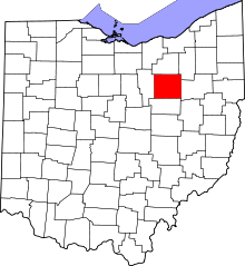 | |
| Villages | ||
| Townships | ||
| CDPs | ||
| Unincorporated communities | ||
| Footnotes | ‡This populated place also has portions in an adjacent county or counties | |