Wadsworth Township, Medina County, Ohio
| Wadsworth Township, Medina County, Ohio | |
|---|---|
| Township | |
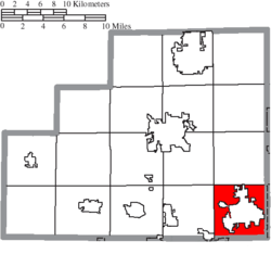 Location of Wadsworth Township in Medina County | |
| Coordinates: 41°2′11″N 81°44′36″W / 41.03639°N 81.74333°WCoordinates: 41°2′11″N 81°44′36″W / 41.03639°N 81.74333°W | |
| Country | United States |
| State | Ohio |
| County | Medina |
| Area | |
| • Total | 16.5 sq mi (42.7 km2) |
| • Land | 16.5 sq mi (42.7 km2) |
| • Water | 0.0 sq mi (0.0 km2) |
| Elevation[1] | 1,194 ft (364 m) |
| Population (2000) | |
| • Total | 3,996 |
| • Density | 242.3/sq mi (93.6/km2) |
| Time zone | UTC-5 (Eastern (EST)) |
| • Summer (DST) | UTC-4 (EDT) |
| ZIP codes | 44281-44282 |
| Area code(s) | 330 |
| FIPS code | 39-80318[2] |
| GNIS feature ID | 1086605[1] |
Wadsworth Township is one of the eighteen townships of Medina County, Ohio, United States. The 2000 census found 3,996 people in the township.[3]
Geography

Located in the southeast corner of the county, it borders the following townships and city:
- Sharon Township - north
- Copley Township, Summit County - northeast corner
- Norton - east
- Chippewa Township, Wayne County - south
- Milton Township, Wayne County - southwest
- Guilford Township - west
- Montville Township - northwest corner
The city of Wadsworth occupies central Wadsworth Township.
Name and history
It is the only Wadsworth Township statewide.[4]
Government
The township is governed by a three-member board of trustees, who are elected in November of odd-numbered years to a four-year term beginning on the following January 1. Two are elected in the year after the presidential election and one is elected in the year before it. There is also an elected township fiscal officer,[5] who serves a four-year term beginning on April 1 of the year after the election, which is held in November of the year before the presidential election. Vacancies in the fiscal officership or on the board of trustees are filled by the remaining trustees.
Public safety in Wadsworth Township is the responsibility of the Wadsworth Fire Department and the Medina County Sheriff's Office.
References
- 1 2 "US Board on Geographic Names". United States Geological Survey. 2007-10-25. Retrieved 2008-01-31.
- ↑ "American FactFinder". United States Census Bureau. Retrieved 2008-01-31.
- ↑ Medina County, Ohio — Population by Places Estimates Ohio State University, 2007. Accessed 15 May 2007.
- ↑ "Detailed map of Ohio" (PDF). United States Census Bureau. 2000. Retrieved 2007-02-16.
- ↑ §503.24, §505.01, and §507.01 of the Ohio Revised Code. Accessed 4/30/2009.
External links
Municipalities and communities of Medina County, Ohio, United States | ||
|---|---|---|
| Cities | 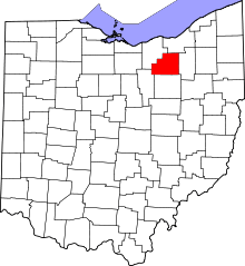 | |
| Villages | ||
| Townships | ||
| Unincorporated communities | ||
| Footnotes | ‡This populated place also has portions in an adjacent county or counties | |