Wooster Township, Wayne County, Ohio
| Wooster Township, Wayne County, Ohio | |
|---|---|
| Township | |
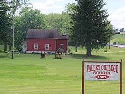 This old schoolhouse is on Route 226 | |
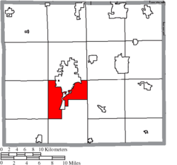 Location of Wooster Township in Wayne County | |
| Coordinates: 40°46′53″N 81°56′34″W / 40.78139°N 81.94278°WCoordinates: 40°46′53″N 81°56′34″W / 40.78139°N 81.94278°W | |
| Country | United States |
| State | Ohio |
| County | Wayne |
| Area | |
| • Total | 20.3 sq mi (52.7 km2) |
| • Land | 20.3 sq mi (52.5 km2) |
| • Water | 0.1 sq mi (0.2 km2) |
| Elevation[1] | 850 ft (259 m) |
| Population (2000) | |
| • Total | 5,250 |
| • Density | 259.2/sq mi (100.1/km2) |
| Time zone | UTC-5 (Eastern (EST)) |
| • Summer (DST) | UTC-4 (EDT) |
| ZIP code | 44691 |
| Area code(s) | 330 |
| FIPS code | 39-86562[2] |
| GNIS feature ID | 1087164[1] |
Wooster Township is one of the sixteen townships of Wayne County, Ohio, United States. The 2000 census found 5,250 people in the township.[3]
Geography
Located in the central part of the county, it borders the following townships:
- Wayne Township - north
- Green Township - northeast corner
- East Union Township - east
- Franklin Township - south
- Clinton Township - southwest corner
- Plain Township - west
- Chester Township - northwest corner
Much of Wooster Township is occupied by the city of Wooster, the county seat of Wayne County. Honeytown is an unincorporated community in the east of the township, just north of Apple Creek.
Name and history
It is the only Wooster Township statewide.[4]
Government
The township is governed by a three-member board of trustees, who are elected in November of odd-numbered years to a four-year term beginning on the following January 1. Two are elected in the year after the presidential election and one is elected in the year before it. There is also an elected township fiscal officer,[5] who serves a four-year term beginning on April 1 of the year after the election, which is held in November of the year before the presidential election. Vacancies in the fiscal officership or on the board of trustees are filled by the remaining trustees.
References
- 1 2 "US Board on Geographic Names". United States Geological Survey. 2007-10-25. Retrieved 2008-01-31.
- ↑ "American FactFinder". United States Census Bureau. Retrieved 2008-01-31.
- ↑ Wayne County, Ohio — Population by Places Estimates Ohio State University, 2007. Accessed 15 May 2007.
- ↑ "Detailed map of Ohio" (PDF). United States Census Bureau. 2000. Retrieved 2007-02-16.
- ↑ §503.24, §505.01, and §507.01 of the Ohio Revised Code. Accessed 4/30/2009.
External links
Municipalities and communities of Wayne County, Ohio, United States | ||
|---|---|---|
| Cities |  | |
| Villages | ||
| Townships | ||
| CDPs | ||
| Unincorporated communities | ||
| Footnotes | ‡This populated place also has portions in an adjacent county or counties | |