Rio, West Virginia
| Rio, West Virginia | |
|---|---|
| Unincorporated community | |
 Rio  Rio | |
| Coordinates: 39°8′18″N 78°40′12″W / 39.13833°N 78.67000°WCoordinates: 39°8′18″N 78°40′12″W / 39.13833°N 78.67000°W | |
| Country | United States |
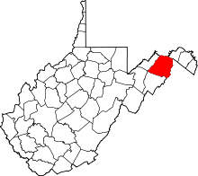
| State | West Virginia |
| County | Hampshire |
| Time zone | UTC-5 (Eastern (EST)) |
| • Summer (DST) | UTC-4 (EDT) |
| GNIS feature ID | 1545756[1] |

Old Rio Schoolhouse.
Rio (pronounced RYE-O) is an unincorporated community in southern Hampshire County in the U.S. state of West Virginia. Rio is located just north of the Hardy County line at the crossroads of Augusta-Ford Hill Road (West Virginia Secondary Route 53) and Delray Road (West Virginia Route 29) in the North River Valley. According to the 2000 census, the Rio community has a population of 154.[2]
The community most likely was named for the nearby North River, rio meaning "river" in Spanish.[3]
Historic sites and attractions

Ebenezer Lutheran Church.
- Rio Turtle, 2.5 mi. West of Rio on Augusta-Ford Hill Road (CR 53)
- Old Rio Schoolhouse, In Rio on Delray Road (WV Route 29)
- Ebenezer Lutheran Church, In Rio on Augusta-Ford Hill Road (CR 53)
- God's Pavilion Church, In Rio in Augusta-Ford Hill Road (CR 53)
- Rio Fun Fair and Parade @ the Old Schoolhouse, 4 July Weekend
References
- ↑ U.S. Geological Survey Geographic Names Information System: Rio, West Virginia
- ↑ Rio, West Virginia ZIP code profile, DownloadZIPCode.com Archived 2005-12-30 at the Wayback Machine.. Accessed 2008-01-19.
- ↑ Kenny, Hamill (1945). West Virginia Place Names: Their Origin and Meaning, Including the Nomenclature of the Streams and Mountains. Piedmont, WV: The Place Name Press. p. 532.
External links
![]()
This article is issued from
Wikipedia.
The text is licensed under Creative Commons - Attribution - Sharealike.
Additional terms may apply for the media files.