Loom, West Virginia
| Loom, West Virginia | |
|---|---|
| Unincorporated community | |
 Loom  Loom | |
| Coordinates: 39°16′43″N 78°30′41″W / 39.27861°N 78.51139°WCoordinates: 39°16′43″N 78°30′41″W / 39.27861°N 78.51139°W | |
| Country | United States |
| State | West Virginia |
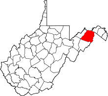
| County | Hampshire |
| Time zone | UTC-5 (Eastern (EST)) |
| • Summer (DST) | UTC-4 (EDT) |
| GNIS feature ID | 1554995[1] |
Loom is an unincorporated community in Hampshire County, West Virginia, United States. Loom (sometimes referred to as Loom Cemetery) is located between Capon Bridge and Hanging Rock along the Northwestern Turnpike (U.S. Route 50) on the western flanks of Cooper Mountain. Timber Mountain Road (County Route 50/22) and Beck's Gap Road (County Route 50/23) converge at Loom on U.S. Route 50.
The community's name was selected from a postal directory for its brevity.[2]
Historic sites
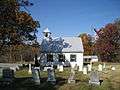
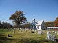
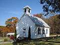
- Central United Methodist Church & Cemetery, US Route 50 East
Image gallery
External links
![]()
References
- ↑ U.S. Geological Survey Geographic Names Information System: Loom, West Virginia
- ↑ Kenny, Hamill (1945). West Virginia Place Names: Their Origin and Meaning, Including the Nomenclature of the Streams and Mountains. Piedmont, WV: The Place Name Press. p. 384.
This article is issued from
Wikipedia.
The text is licensed under Creative Commons - Attribution - Sharealike.
Additional terms may apply for the media files.