Rhodes (city)
| Rhodes Ρόδος | |||
|---|---|---|---|
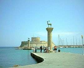 View of the harbour. | |||
| |||
 Rhodes Location within Rhodes  | |||
| Coordinates: 36°26′N 28°13′E / 36.433°N 28.217°ECoordinates: 36°26′N 28°13′E / 36.433°N 28.217°E | |||
| Country | Greece | ||
| Administrative region | South Aegean | ||
| Regional unit | Rhodes | ||
| Municipality | Rhodes | ||
| • Municipal unit | 19.481 km2 (7.522 sq mi) | ||
| Highest elevation | 25 m (82 ft) | ||
| Lowest elevation | 0 m (0 ft) | ||
| Population (2011)[1] | |||
| • Metro | 86,199 | ||
| • Municipal unit | 49,541 | ||
| • Municipal unit density | 2,500/km2 (6,600/sq mi) | ||
| Demonym(s) | Rhodian | ||
| Time zone | UTC+2 (EET) | ||
| • Summer (DST) | UTC+3 (EEST) | ||
| Postal code | 851 00, 31, 32, 33 | ||
| Area code(s) | 2241 | ||
| Vehicle registration | PO, PK, PY | ||
| Website | www.rhodes.gr | ||
| UNESCO World Heritage site | |||
| Official name | Medieval City of Rhodes | ||
| Criteria | Cultural: (ii)(iv)(v) | ||
| Reference | 493 | ||
| Inscription | 1988 (12th Session) | ||
| Area | 65.85 ha (162.7 acres) | ||
Rhodes (Greek: Ρόδος, Ródos [ˈroðos]) is the principal city and a former municipality on the island of Rhodes in the Dodecanese, Greece. Since the 2011 local government reform it is part of the municipality Rhodes, of which it is the seat and a municipal unit.[2] It has a population of approximately 90,000 in its metropolitan area. Rhodes has been famous since antiquity as the site of Colossus of Rhodes, one of the Seven Wonders of the Ancient World. The citadel of Rhodes, built by the Hospitalliers, is one of the best-preserved medieval towns in Europe, which in 1988 was designated as a UNESCO World Heritage Site.
The city of Rhodes is an important urban center and popular international tourist destination.
Geography
The city of Rhodes is situated in the north-east tip of the island and forms a triangle from north to south. The municipal unit has an area of 19.481 km2.[3] It is the smallest municipal unit of the island in terms of land area and the largest in population. It borders the Aegean Sea to the north, the east and the west and with the municipalities of Ialysos and Kallithea in the south.
History

The island of Rhodes is at a crossroads between Europe, the Middle East, and Africa. This has given the city and the island many different identities, cultures, architectures, and languages over its long history. Its position in major sea routes has given Rhodes a very rich history. The island has been inhabited since about 4000 BC (Neolithic Period).[4]
Classical period
The city of Rhodes was formed by the cities of Ialyssos, Kamiros and Lindos in 408 BC,[4] and prospered for three centuries during its Golden Age, when sea trade, skilled shipbuilders, and open-minded politicians of the city kept it prosperous until Roman times. The Colossus of Rhodes, one of the original Seven Wonders of the Ancient World was built by the Lindian sculptor Chares between 304 and 293 BC,[4] which took 12 years and was completed in 282 BC. The statue represented their sun god Helios, which stood at the harbour entrance. The ancient city had a well-constructed sewage system as well as a water supply network as designed by Hippodamus. A strong earthquake hit Rhodes about 226 BC, badly damaging the city and toppling the Colossus.[4]
Roman period
In 164 BC, Rhodes came under Roman control.[5] It was able to keep its beauty and develop into a leading center of learning for arts and science. The Romans took from the Rhodians their maritime law and applied it to their shipping. Many traces of the Roman period still exist throughout the city and give an insight into the level of civilization at the time.[5] According to Acts 21:1, the Apostle Paul stopped at Rhodes near the end of his third missionary journey.
Byzantine period
In medieval times, Rhodes was an important Byzantine trading post, as also a crossroads for ships sailing between Constantinople and Alexandria. In the early years of the divided Roman Empire, the Isaurians, a mountain tribe from Cilicia, invaded the island and burned the city. In the 7th century AD it was captured by the Arabs. The latter were the ones who removed the scattered pieces of the Colossus from the port and moved them to Syria where they destroyed them to make coins. After the fall of the Byzantine Empire to the Fourth Crusade in 1204, the native noble Leo Gabalas took control of the island, but after his death and succession by his brother John, the island was briefly occupied by the Genoese before being returned to the Emperor of Nicaea, though ushering in a new, but short-lived, Byzantine period.
Knights' period
The Knights Hospitallers captured and established their headquarters on Rhodes when they left Cyprus[6][7] after the persecution of the Knights Templar in 1307. Pope Clement V confirmed the Hospitallers possession of the Island in 1309. The Knights remained on the Island for the next two centuries.
In 1444, the Mamluk fleet of Egypt laid a siege to Rhodes, but the Knights aided by the Burgundian naval commander Geoffroy de Thoisy beat off the Muslim attack.
After the Fall of Constantinople in 1453 the Ottoman Empire began a rapid expansion and in 1480 Sultan Mehmet launched an invasion of Rhodes commanded by Mesic Pasha. The defenders repelled Turkish attacks from both landward and seaward sides and the invaders left the Island in defeat. The defeat halted a concurrent invasion of the Italian peninsula by Ottoman forces and prevented possible Muslim incursion and control of Western Europe.
After the Ottoman defeat in 1480 the Knights Grand Master, Pierre d'Aubusson, oversaw the strengthening of the cities over the next few decades. By the time of his death in 1521 Rhodes possessed the strongest fortifications of any Christian Bastion in the World. The Knights continued naval attacks launched from Rhodes on Muslim merchants until 1522 when the newly enthroned Sultan Suleiman the Magnificent led a second Siege of Rhodes in 1522.
The vastly outnumbered Knights made a spirited defense of the city and inflicted heavy casualties upon the Ottoman besiegers. In December 1522 the Knights and Suleiman came to terms and the Knights were allowed to leave the city with all the wealth they could carry, in return there would be no retribution upon the inhabitants of the city and they would be allowed to continue to freely practice Christianity. On January 1, 1523 the Knights departed from the island, leaving it to Ottoman control.
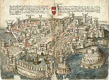
Ottoman period

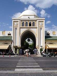
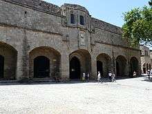
_03.jpg)
In the Ottoman era, new buildings were constructed: mosques, public baths and mansions for the new patrons. The Greeks were forced to abandon the fortified city and move to new suburbs outside its walls. The city maintained its main economic function as a market for the agricultural products of the interior of the island and the surrounding small islands.
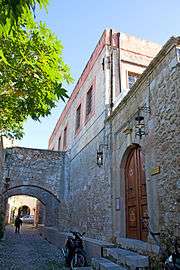
After the establishment of their sovereignty οn the island, the Ottoman Turks converted most of the churches into mosques and transformed the major houses into private mansions or public buildings. This transformation was a long-term process that aimed to adapt the buildings to the Ottoman way of living. The Knights period façades with their sculptured decorations, the arched gates and hewn stone walls were enriched with the random character of the Ottoman architecture adapted to the local climate and culture. Ιn this process most οf the architectural features of the existing buildings were preserved. The most characteristic additions were the baths (usually in the back of the buildings) and the enclosed wooden balconies οn the façades over the narrow streets.In this way most of the buildings of the Hospitaliers' period in the Medieval Town were well preserved. The result was a mixture of oriental architecture with imposing western architectural remains and more recent buildings, which were characteristic of the local architecture of the time.
An interesting example of the Ottoman architecture is the building of the Hafiz Ahmed Agha Library.
Ιn the 19th century, the city was the capital of the Eyalet of the Archipelago, but the decline of the Ottoman Empire resulted in the general neglect of the town and its buildings, which further deteriorated due to the strong earthquakes that often plague the area.
Italian period
In 1912 Italian troops took the island over with the rest of the Dodecanese Islands, and established an Italian possession known as Italian Islands of the Aegean in 1923.[8] Father of Italian Rhodes can be considered the Italian architect Florestano Di Fausto. He, in agreement with governor Mario Lago, was author of the city plan of 1923, choosing to respect almost totally the walled town, only demolishing the houses that were built on and around the city walls during the Ottoman era. He also turned the Jewish and Ottoman cemeteries into a green zone surrounding the Medieval Town.[8] At the same time, he designed the new Italian Rhodes in the zone of the Mandraki, planning a Garden City, and building along the main sea promenade the main edifices, as the Market, the Cathedral of Saint John of the Knights, the Palace of the governor. All these building were designed in an eclectic style, mixing Ottoman, Venetian, Renaissance and local elements. The Italians preserved what was left from the Knights' period, and destroyed all Ottoman buildings. They also reconstructed the Grand Master's Palace.[8] Furthermore, an Institute for the study of the History and Culture of the region was established, and major infrastructure work was done to modernize Rhodes.[8]
Post-World War II period
The British bombs that fell on the medieval city of Rhodes in 1944 claimed human lives and destroyed a great number of buildings, leaving large gaps in the urban tissue. One of the first Decrees of the Greek administration designated those areas as reserved for future excavations and a number of edifices as safeguarded buildings. In July 1944 the Nazis ordered the deportation of over 1,600 Jews of Rhodes including men, women, and children of which 1,200 were murdered at Auschwitz.[9]
In 1957, a new city plan was approved by a Decree and in 1960 the entire medieval town was designated as a protected monument by the Ministry of Culture. In 1961 and 1963 new Decrees were issued concerning the new city plan. They provided for the widening of existing streets and the opening of new ones. These were not implemented in the old city due to the resistance of the Archaeological Service. In 1988, the old town of Rhodes was designated as a World Heritage City by UNESCO.
Government
Rhodes City is the capital of the island of Rhodes which since 2011 became a single municipality and of the Rhodes regional unit. It was the capital of the former Dodecanese Prefecture and currently hosts many offices and services of the South Aegean region.
As an administration centre, the city also hosts numerous offices and services such as:
- Dodecanese Police Headquarters
- Rhodes Fire Department
- Dodecanese Courthouse
- Dodecanese Port Police/Coastguard
- 95 ADTE (Hellenic Army Division Headquarters)
- Rhodes Public Tax Office
- Rhodes Urban Planning Office
- Rhodes Land Registry Office
- Rhodes Hellenic Post Office headquarters
- Rhodes Municipal Water & Sewage Company
- Dodecanese Chamber of Commerce
- Rhodes Manpower Office (OAED)
- Rhodes Social Security Institute (IKA)
- Public Power Corporation (DEI)
Main sights
The city is home to numerous landmarks. Some of them date back to antiquity and most of the others remain from the Knights' Period.
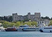
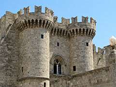
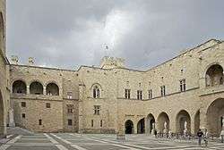
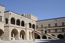
- Grand Master's Palace (15th century)
- Knights Street
- La Juderia, including the Kahal Shalom Synagogue
- Acropolis of Rhodes
- Mosque of Suleiman the Magnificent
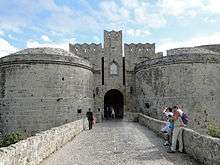
- Medieval walls, created in the mid-14th century on a previous line and remade after the Ottoman siege of 1480 and the earthquake of the following year. In 1522 Suleiman entered the city from the gate of St. Anastasius
- Gothic buildings in the historical upper town.
- Recently, the Byzantine harbor was excavated, discovering unique medieval shipwrecks.
- St. Francis of Assisi Cathedral, Rhodes
Demographics


Both city and island population continue to grow contrary to national levels; the city has an official permanent population of 49,541 in 2011 census but its estimated that some 65-70.000 reside permanently within city limits. During summer population reaches 100.000 due to some 25-30.000 hotel beds operating within city limits as well numerous seasonal workers that migrate from rest of Greece due to high unemployment mostly in peninsular parts of the country.
| Year | Population | Change +/- |
|---|---|---|
| 1951 | 24,280 | - |
| 1961 | 28,119 | +3,839 |
| 1971 | 33,100 | +4,981 |
| 1981 | 41,425 | +8,325 |
| 1991 | 43,558 | +2,133 |
| 2001 | 53,709 | +10,151 |
| 2011 | 49,541 | -4,168 |
Education
State facilities by category:
- Primary Education: 21 primary schools
- Secondary Education: 7 high schools and 7 lyceums
- Higher Education: Some departments of the Aegean University, Higher and Lower Tourism Schools and some private institutes
The last years two private schools were also established and offer classes from primary to lyceum education with one located within city limits, Rodion Paideia. The Music School of Rhodes (Greece) can be located just outside Rhodes, in Koskinou village.
Health
Rhodes state general hospital is located in the southwestern district of Agioi Apostoloi. Erected less than 20 years ago, its a modern facility with many departments as well the base for EKAV ambulances serving the city and island's northern part. Hospital is also equipped with a helicopter landing zone being able to accept urgent cases via airlifts from the rest Dodecanese islands.
A private hospital, Euromedica, also operates just off city limits, in Koskinou western edge. Numerous private medical facilities also operate within city while many private doctors keep their clinics in and around city centre.
Transportation
Air
Both the city and the island of Rhodes are served by Diagoras International Airport, situated 14 km (9 mi) south west of the city. It is connected to all other major Greek airports and to Cyprus throughout the year. During tourism season, international flights connect the island with numerous European cities and with Israel, Egypt and Lebanon.
Sea
City hosts 3 major ports that each serve a different purpose. Kolona serves intradodecanese traffic, Central serves cruise ships and international traffic and Akandia domestic as well cargo traffic.
Ferries connect daily the island with several nearby islands within the Dodecanese Islands, as well as with the Cycladic Islands and the Greek mainland (Pireaus) while twice weekly a ferry goes to Heraklion, Crete. There are also frequently routes to opposing Turkish coast towns such as Marmaris and Fethiye. Rhodes is also a popular port of call for cruise itineraries, especially in the summer months.
City also hosts two marinas, a municipal one in downtown Mandraki and a private one next to Akandia port.
Surface
The city's public transit system is served by municipal bus company RODA (blue and/or white buses) and consists of a bus network which connects city centre to districts but also connects the city to outlying resorts and towns (Faliraki in the east and Ixia, Ialysos, Tholos in the west) as well Rhodes International Airport. City centre is also point of departure for KTEL buses (orange buses) that serve island's east coast suburban routes. There is a proposal for KTEL buses to relocate in available space next to Akandia port but its still unknown if and when this will happen.
Taxis are widely available in the city and usually can be found in designated taxi ranks or via phone call. Its normal during high season rush hours to queue in ranks due to increased demand.
Plans for a 16 km tram network consisting of 2 lines and 13 stations were presented years ago but since then nothing further emerged probably due to lack of funds.
City's road network is mostly old consisting mainly of narrow and one way streets and major arteries can't really cope with increased traffic making congestion unavoidable especially rush hours. Parking especially around city centre and during market hours as well summer season is extremely difficult due to lack of free spaces although its monitored by the municipality imposing a fee. Municipality is currently redeveloping certain free areas near the centre to parking lots which are expected to lower traffic burden. A ring road also exists but its unfinished connecting currently Rhodes Port to Rhodes-Kallithea Avenue. City is also the starting point of 3 of island's 5 main avenues connecting it with Faliraki through Rhodes-Kallithea Avenue, Lindos through Rhodes-Lindos Avenue and west coast (Ialysos, Airport, Tholos, Kamiros) through Rhodes-Kamiros Avenue.
Media
Television and radio
Most major nationwide television stations broadcast in the city. There are also five local television stations and a number of local and national radio stations.
Newspapers
There are two daily newspapers issued that deal with both the city and the whole region. Moreover there are few others with specific themes.
Sports
The city after a long dark period of almost 15 years is reviving in many team sports. Football and basketball are the most popular but a wide variety is also in development during the last years with the most noticeable in rugby.
Football
The city has two major football teams; Diagoras GS and AS Rodos after a long period are back in national level and competed in Greek National Second Division (Football League) during 2017-18 season with the latter being relegated to local league. Rest of the city based teams compete in the local Amateur Divisions and include teams that once competed in national level such as ARS Rodiakos and DANS Dorieas.
Basketball
The last 15 years basketball is represented in national level by Kolossos Rodou BC which competes in National A1 Ethniki since 2007. Other teams, either active or defunct, are AS Diagoras Rhodes with notable presence some years ago in national lower level leagues C and B, Rodion Athlisis, Galazia Akadimia and now defunct ASK Ibiskos, DANS Dorieas and AS Rodos. City also hosts AS Dodekanisos, the pride of the Aegean that competes and stars in the national basketball league for handicapped people.
Volleyball
Rodion Athlisis competes successfully during the last years in A2 Ethniki Volleyball and lost promotion to top tear A1 Ethniki Volleyball for 2 consecutive seasons (2017 and 2018) in play off games. Rest of city based teams compete in local level.
Other
A variety of other sports is also available and in development in the city. In rugby the recently formed Colossoi of Rhodes reached the top league finals for the second time in a row. The Nautical Club of Rhodes and Ygros Stivos of Rhodes have water polo teams in low level national divisions; the Rhodian Tennis Club play tennis and ping-pong in its privately owned facilities; AS Diagoras Rhodes have competitive teams in cycling and in track and field athletics. Finally ziu zitsu, karate, tae-kwon-do and other Eastern oriented sports are available with local teams that enjoy sporadic national success.
Sports venues
The city has three major sports venues; the Rhodes Municipal Stadium and the Kallipateira National Athletic Center serve all outdoor activities while the Municipal Indoor Hall of "Venetokleio" serves indoor sports. Agioi Apostoloi municipal stadium serves solely football while privately owned indoor sports arenas are hold by Diagoras and Rodion Athlisis clubs with the latter owning and operating also a 25m indoor swimming pool as well.
Climate
In Köppen climate classification, it is classified as hot-summer Mediterranean climate. The lowest recorded temperature −3 °C (27 °F) and the highest recorded temperature was 42 °C (108 °F).
| Climate data for Rhodes | |||||||||||||
|---|---|---|---|---|---|---|---|---|---|---|---|---|---|
| Month | Jan | Feb | Mar | Apr | May | Jun | Jul | Aug | Sep | Oct | Nov | Dec | Year |
| Record high °C (°F) | 22.0 (71.6) |
22.0 (71.6) |
27.4 (81.3) |
30.6 (87.1) |
34.8 (94.6) |
36.2 (97.2) |
39.0 (102.2) |
41.2 (106.2) |
35.4 (95.7) |
33.2 (91.8) |
28.4 (83.1) |
22.8 (73) |
41.2 (106.2) |
| Average high °C (°F) | 15.1 (59.2) |
15.2 (59.4) |
16.8 (62.2) |
20.0 (68) |
24.2 (75.6) |
28.4 (83.1) |
30.5 (86.9) |
30.7 (87.3) |
28.2 (82.8) |
24.5 (76.1) |
20.1 (68.2) |
16.6 (61.9) |
22.5 (72.6) |
| Daily mean °C (°F) | 12.0 (53.6) |
12.0 (53.6) |
13.5 (56.3) |
16.3 (61.3) |
20.0 (68) |
24.2 (75.6) |
26.4 (79.5) |
26.7 (80.1) |
24.4 (75.9) |
20.7 (69.3) |
16.7 (62.1) |
13.5 (56.3) |
18.9 (66) |
| Average low °C (°F) | 8.8 (47.8) |
8.8 (47.8) |
10.1 (50.2) |
12.5 (54.5) |
15.8 (60.4) |
19.9 (67.8) |
22.3 (72.1) |
22.7 (72.9) |
20.5 (68.9) |
16.9 (62.4) |
13.2 (55.8) |
10.4 (50.7) |
15.2 (59.3) |
| Record low °C (°F) | −4.0 (24.8) |
−1.6 (29.1) |
0.2 (32.4) |
5.2 (41.4) |
8.6 (47.5) |
12.6 (54.7) |
16.8 (62.2) |
17.0 (62.6) |
10.6 (51.1) |
7.2 (45) |
2.4 (36.3) |
1.2 (34.2) |
−4.0 (24.8) |
| Average rainfall mm (inches) | 149.6 (5.89) |
105.7 (4.161) |
75.6 (2.976) |
27.8 (1.094) |
18.6 (0.732) |
2.3 (0.091) |
0.4 (0.016) |
0.2 (0.008) |
5.8 (0.228) |
65.5 (2.579) |
94.1 (3.705) |
157.4 (6.197) |
703 (27.677) |
| Average rainy days | 15.5 | 12.7 | 10.5 | 7.6 | 4.6 | 1.2 | 0.2 | 0.1 | 1.5 | 6.7 | 9.5 | 15.4 | 85.5 |
| Average relative humidity (%) | 70.1 | 69.1 | 68.7 | 66.5 | 64.4 | 58.5 | 57.6 | 59.9 | 61.4 | 67.5 | 71.4 | 72.4 | 65.6 |
| Mean daily sunshine hours | 5.0 | 6.0 | 7.0 | 9.0 | 11.0 | 13.0 | 14.0 | 13.0 | 11.0 | 8.0 | 6.0 | 5.0 | 9 |
| Percent possible sunshine | 50 | 55 | 58 | 69 | 79 | 87 | 100 | 100 | 92 | 73 | 60 | 50 | 73 |
| Source #1: Hellinic National Meteorological Service [10] | |||||||||||||
| Source #2: NOAA (Record temperature),[11] Weather Atlas (sunshine data)[12] | |||||||||||||
| Climate data for Rhodes | |||||||||||||
|---|---|---|---|---|---|---|---|---|---|---|---|---|---|
| Month | Jan | Feb | Mar | Apr | May | Jun | Jul | Aug | Sep | Oct | Nov | Dec | Year |
| Average sea temperature °C (°F) | 17.9 (64.2) |
17.0 (62.6) |
17.1 (62.8) |
17.6 (63.7) |
20.1 (68.2) |
23.4 (74.1) |
25.9 (78.6) |
27.2 (81.0) |
26.7 (80.1) |
23.8 (74.8) |
20.9 (69.6) |
18.8 (65.8) |
21.4 (70.5) |
| Mean daily daylight hours | 10.0 | 11.0 | 12.0 | 13.0 | 14.0 | 15.0 | 14.0 | 13.0 | 12.0 | 11.0 | 10.0 | 10.0 | 12.1 |
| Average Ultraviolet index | 2 | 3 | 5 | 7 | 8 | 10 | 10 | 9 | 7 | 5 | 3 | 2 | 5.9 |
| Source: Weather Atlas [12] | |||||||||||||
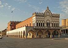
International relations
_01.jpg)
Consulates
The city of Rhodes is also home to many foreign consulates.[13]
Twin towns — sister cities
Rhodes is twinned with:
|
Notable people

Ancient
- Diagoras of Rhodes
- Apollonius of Rhodes, poet
- Dinocrates, architect
- Hieronymus of Rhodes, philosopher
- Panaetius, philosopher
Modern
- Panagiotis Rodios, politician, fighter during the Greek War of Independence
- Reşit Galip, Turkish politician
- Oreste Lionello, Italian actor
- Giorgos Skartados, football player
- Niki Xanthou, Greek athlete
Gallery
 The ancient theatre, Acropolis of Rhodes
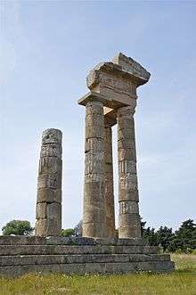
 Remains of the Temple of Aphrodite, c.3rd century BC
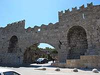 Gate of the arsenal
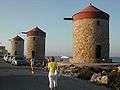 Windmills
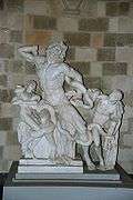 Laocoön and His Sons; copy in the Grand Master's Palace
_01.jpg) Byzantine church of Agios Georgios
Byzantine church of Agios Georgios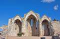 Medieval church of the Virgin
 Statue of Francis of Assisi in front of the St. Francis of Assisi Cathedral, Rhodes
 Bronze deer at the harbour
 Fort Saint Nicolas
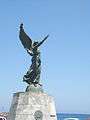 WWII memorial
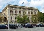 Main post office, by Di Fausto
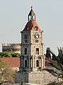 Clocktower
 Pitaroudia, traditional food from Rhodes and Dodecanese
References
- ↑ "Απογραφή Πληθυσμού - Κατοικιών 2011. ΜΟΝΙΜΟΣ Πληθυσμός" (in Greek). Hellenic Statistical Authority.
- ↑ Kallikratis law Greece Ministry of Interior (in Greek)
- ↑ "Population & housing census 2001 (incl. area and average elevation)" (PDF) (in Greek). National Statistical Service of Greece. Archived from the original (PDF) on 2015-09-21.
- 1 2 3 4 "History of Rhodes: Classical Period". Municipality of Rhodes. www.rhodes.gr. 2007. Archived from the original on 2016-05-05. Retrieved 2012-04-11.
- 1 2 "History of Rhodes: Roman Period". Municipality of Rhodes. www.rhodes.gr. 2007. Archived from the original on 2016-04-21. Retrieved 2012-04-11.
- ↑ David Nicolle "Knights of Jerusalem: the crusading order of Hospitallers 1100-1565" – Osprey Publishing, 2008
- ↑ Gino Manicone "Rodi sposa del sole", Casamari, La Monastica, 1992.
- 1 2 3 4 "History of Rhodes: Italian Period". Municipality of Rhodes. www.rhodes.gr. 2007. Archived from the original on 2016-04-21. Retrieved 2012-04-11.
- ↑ "Jewish Community of Rhodes". Retrieved 10 May 2015.
- ↑ "Climatology - Rodos". Hellinic National Meteorological Service. Retrieved 24 March 2017.
- ↑ "Rhodes Climate Normals 1961–1990". National Oceanic and Atmospheric Administration. Retrieved March 1, 2015.
- 1 2 "Rhodes, Greece - Climate data". Weather Atlas. Retrieved 24 March 2017.
- ↑ "Tourists Information: Foreign States Consulates". Municipality of Rhodes. www.rhodes.gr. 2006. Archived from the original on 2012-01-21. Retrieved 2012-04-11.
- ↑ "Limassol Twinned Cities". Limassol (Lemesos) Municipality. Archived from the original on 2013-04-01. Retrieved 2013-07-29.
External links
| Wikimedia Commons has media related to Rhodes (city). |
| Wikivoyage has a travel guide for Rhodes (city). |