Pyrgos, Elis
| Pyrgos Πύργος | ||
|---|---|---|
 Pyrgos municipality | ||
| ||
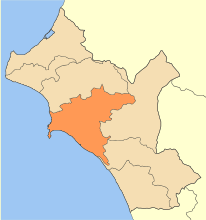
 Pyrgos Location within the region 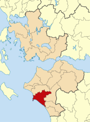 | ||
| Coordinates: 37°40′N 21°26′E / 37.667°N 21.433°ECoordinates: 37°40′N 21°26′E / 37.667°N 21.433°E | ||
| Country | Greece | |
| Administrative region | West Greece | |
| Regional unit | Elis | |
| Government | ||
| • Mayor | Gavrilis Liatsis | |
| Area | ||
| • Municipality | 456.6 km2 (176.3 sq mi) | |
| • Municipal unit | 170.9 km2 (66.0 sq mi) | |
| Highest elevation | 3 m (10 ft) | |
| Lowest elevation | 0 m (0 ft) | |
| Population (2011)[1] | ||
| • Municipality | 47,995 | |
| • Municipality density | 110/km2 (270/sq mi) | |
| • Municipal unit | 35,572 | |
| • Municipal unit density | 210/km2 (540/sq mi) | |
| Community[1] | ||
| • Population | 25,180 (2011) | |
| Time zone | UTC+2 (EET) | |
| • Summer (DST) | UTC+3 (EEST) | |
| Postal code | 271 xx | |
| Area code(s) | 26210 | |
| Vehicle registration | HA | |
| Website | ||

Pyrgos (Greek: Πύργος, meaning "tower") is the capital of the Elis regional unit in Greece. The city is located in the western part of the Peloponnese, in the middle of a plain, 4 kilometres (2 miles) from the Ionian Sea. The river Alfeios flows into sea about 7 km (4 mi) south of Pyrgos. The population of the town Pyrgos is 25,180, and of the municipality 47,995 (2011). Pyrgos is 16 km (10 mi) west of Olympia, 16 km (10 mi) southeast of Amaliada, 70 km (43 mi) southwest of Patras and 85 km (53 mi) west of Tripoli.
Historical population
| Year | Town population | Municipal unit population | Municipality population |
|---|---|---|---|
| 1981 | 21,958 | - | - |
| 1991 | 28,465 | 39,183 | - |
| 2001 | 23,791 | 34,902 | 51,777 |
| 2011 | 24,359 | 35,572 | 47,995 |
Municipality

The municipality Pyrgos was formed during the 2011 local government reform by the merger of the following 4 former municipalities, that became municipal units:[2]
The municipality has an area of 456.610 km2, the municipal unit 170.866 km2.[3]
Subdivisions
The municipal unit of Pyrgos is divided into the following communities (settlements within the communities given in brackets):
- Pyrgos (Pyrgos, Anthopyrgos, Kavasilakia, Lampeti, Syntriada, Tragano)
- Agios Georgios
- Agios Ilias (Agios Ilias, Pyrgi, Stamatelaiika)
- Agios Ioannis (Agios Ioannis, Kyani Akti, Palatas, Tragano)
- Ampelonas (Ampelonas, Kouzouli, Rozeika)
- Elaionas (Elaionas, Vytinaiika)
- Granitsaiika (Granitsaiika, Kavouri)
- Katakolo (Katakolo, Agios Andreas)
- Koliri (Koliri, Kolireikes Paragkes)
- Korakochori (Korakochori, Agios Andreas, Kallithea, Bouka)
- Lasteika (Lasteika, Itia)
- Leventochori
- Myrtia
- Palaiovarvasaina (Palaiovarvasaina, Agios Georgios, Kampos)
- Salmoni (Salmoni, Alfeios)
- Skafidia (Skafidia, Kalakaiika, Moni Skafidias, Patronikoleika)
- Skourochori (Skourochori, Kato Kavouri)
- Varvasaina (Varvasaina, Kato Varvasaina)
- Vytinaiika
History
History of the name
In the 1510s, during Ottoman rule over Greece, a villager from Tsorota of Kalavryta decided to move and reform the area of Pyrgos which up until then was uncultivated. During this reformation he found in a well a large amount of gold ancient coins which he delivered to the Sultan as the rightful owner. The Sultan, Selim I (1470-1520), in order to honor his integrity named him ruler of the region (1512) and gave him a great acreage expanding from Alfeios river until the village Agios Ioannis which is located near Katakolo (the main port of the Elis region). This area was encompassing today’s Pyrgos and was uninhabited. According to the stories the new ruler built a great tower (Πύργος, pyrgos in Greek) on a hill in order to supervise his fields and his flocks. This was the first settlement of the area.[4][5][6]
Climate
Pyrgos has a hot-summer mediterranean climate (Köppen climate classification Csa) with hot and dry summers and rainy winters with generally mild temperatures. Annual precipitation is sizeable, above 900 mm, and it peaks in late autumn.
| Climate data for Pyrgos | |||||||||||||
|---|---|---|---|---|---|---|---|---|---|---|---|---|---|
| Month | Jan | Feb | Mar | Apr | May | Jun | Jul | Aug | Sep | Oct | Nov | Dec | Year |
| Average high °C (°F) | 14.6 (58.3) |
15.0 (59) |
17.2 (63) |
19.8 (67.6) |
24.6 (76.3) |
28.9 (84) |
31.7 (89.1) |
31.8 (89.2) |
29.1 (84.4) |
24.7 (76.5) |
19.3 (66.7) |
15.9 (60.6) |
22.7 (72.9) |
| Daily mean °C (°F) | 9.6 (49.3) |
10.1 (50.2) |
12.2 (54) |
15.0 (59) |
19.6 (67.3) |
23.8 (74.8) |
26.3 (79.3) |
26.1 (79) |
23.0 (73.4) |
18.5 (65.3) |
13.9 (57) |
11.0 (51.8) |
17.4 (63.4) |
| Average low °C (°F) | 4.8 (40.6) |
5.1 (41.2) |
6.3 (43.3) |
8.6 (47.5) |
12.0 (53.6) |
14.9 (58.8) |
17.0 (62.6) |
17.4 (63.3) |
15.1 (59.2) |
12.3 (54.1) |
9.1 (48.4) |
6.5 (43.7) |
10.8 (51.4) |
| Average rainfall mm (inches) | 136.4 (5.37) |
111.5 (4.39) |
71.5 (2.815) |
63.3 (2.492) |
24.0 (0.945) |
8.2 (0.323) |
4.5 (0.177) |
14.7 (0.579) |
27.7 (1.091) |
103.4 (4.071) |
194.0 (7.638) |
161.7 (6.366) |
920.9 (36.257) |
| Average rainy days | 12.2 | 11.5 | 9.6 | 8.5 | 5.6 | 1.9 | 0.7 | 1.3 | 3.2 | 8.0 | 12.2 | 13.2 | 87.9 |
| Average relative humidity (%) | 73.5 | 71.8 | 71.1 | 70.5 | 67.7 | 62.4 | 60.1 | 62.5 | 67.0 | 70.8 | 75.2 | 75.5 | 69 |
| Mean monthly sunshine hours | 143.2 | 147.4 | 193.4 | 227.2 | 285.3 | 332.3 | 360.4 | 333.9 | 263.6 | 215.2 | 152.5 | 124.9 | 2,779.3 |
| Source: Hellenic National Meteorological Service[7] | |||||||||||||
Transportation

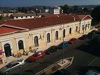
Pyrgos has a train station with regular trains to the port of Katakolo and Olympia. Service on the line from Patras to Kalamata via Pyrgos has been suspended in 2011. Pyrgos has a bus terminal, served by KTEL Ileias, with regular buses for the regional routes to most places in Elis as well as for intercity routes to larger cities such as Patras, Kalamata, Ioannina, Athens and Thessaloniki.[8] The Greek National Road 9 connects Pyrgos with Patras and Kyparissia, the Greek National Road 74 run from Pyrgos to Tripoli via Olympia. The nearest airport is located in Andravida near the town of Amaliada but it is served for military operations only. However there are plans to open passenger operations in the next years. The alterative airports for passenger operations are Araxos airport. located in the province of Aichaia about 60 km or Kalamata Captain Vasilios Constatakopoulos airport, in Messinia province near Kalamata about 120 km from the city.
Sporting teams
- Paniliakos F.C. (played in the first division during the 2003–2004 season)
Notable people

- Andreas Avgerinos (1820–1895), politician
- Petros Avgerinos (19th century), politician, mayor of Pyrgos
- Nakis Avgerinos (1911–2001), politician
- Giorgos Karagounis (1977-), footballer
- Kostas Kazakos (1935-), actor and politician
- George Pavlopoulos (1924-2008), poet
- Takis Sinopoulos (1917–1981), poet
- Stephanos Stephanopoulos (1898–1982), politician and 165th Prime Minister of Greece
- Theodoros Xydis, (1909-1985), poet and essayist.
- Sakis Karagiorgas, (1930-1985), professor and Panteion University Rector[9]
See also
References
- 1 2 "Απογραφή Πληθυσμού - Κατοικιών 2011. ΜΟΝΙΜΟΣ Πληθυσμός" (in Greek). Hellenic Statistical Authority.
- ↑ Kallikratis law Greece Ministry of Interior (in Greek)
- ↑ "Population & housing census 2001 (incl. area and average elevation)" (PDF) (in Greek). National Statistical Service of Greece.
- ↑ Κάπος, Μιλτιάδης (1996). Η Ηλεία στο μύθο και την ιστορία. Athens. ISBN 9789608301078.
- ↑ Δόξας, Τάκης (1965). Το χρονικό του Πύργου. Pyrgos.
- ↑ "Η πόλη του Πύργου και το όνομά της | Δημόσια Κεντρική Βιβλιοθήκη Πύργου". vivliothiki-pirgou.gr (in Greek). Retrieved 2017-04-29.
- ↑ "Mean Pyrgos Climatic Averages". Hellenic National Meteorological Service. Retrieved 14 June 2015.
- ↑ KTEL Ileias
- ↑ el:Σάκης Καράγιωργας
External links
Places adjacent to Pyrgos, Elis | ||||||||||
|---|---|---|---|---|---|---|---|---|---|---|
| ||||||||||
| Regional unit of Achaea | 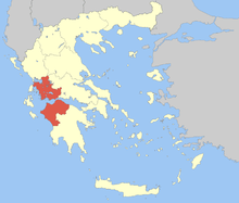 | |
|---|---|---|
| Regional unit of Aetolia-Acarnania | ||
| Regional unit of Elis | ||
| ||