Lindos
| Lindos Λίνδος | |
|---|---|
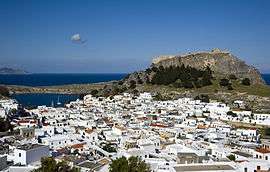 Overview of Lindos | |
 Lindos Location within Rhodes 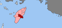 | |
| Coordinates: 36°05′N 28°05′E / 36.083°N 28.083°ECoordinates: 36°05′N 28°05′E / 36.083°N 28.083°E | |
| Country | Greece |
| Administrative region | South Aegean |
| Regional unit | Rhodes |
| • Municipal unit | 178.9 km2 (69.1 sq mi) |
| Highest elevation | 5 m (16 ft) |
| Lowest elevation | 0 m (0 ft) |
| Population (2011)[1] | |
| • Municipal unit | 3,957 |
| • Municipal unit density | 22/km2 (57/sq mi) |
| Community[1] | |
| • Population | 1,087 (2011) |
| Time zone | UTC+2 (EET) |
| • Summer (DST) | UTC+3 (EEST) |
| Postal code | 851 07 |
| Area code(s) | 22440 |
| Vehicle registration | ΚΧ, ΡΟ, ΡΚ |
Lindos (/ˈlɪndɒs/; Greek: Λίνδος) is an archaeological site, a fishing village and a former municipality on the island of Rhodes, in the Dodecanese, Greece. Since the 2011 local government reform it is part of the municipality Rhodes, of which it is a municipal unit.[2] The municipal unit has an area of 178.9 km2.[3] It lies on the east coast of the island. It is about 50 km south of the town of Rhodes and its fine beaches make it a popular tourist and holiday destination. Lindos is situated in a large bay and faces the fishing village and small resort of Charaki.
History
Lindos was founded by the Dorians led by the king Tlepolemus of Rhodes, who arrived in about the 10th century BC. It was one of six Dorian cities in the area known as the Dorian Hexapolis. The eastern location of Rhodes made it a natural meeting place between the Greeks and the Phoenicians, and by the 8th century Lindos was a major trading centre. In the 6th century it was ruled by Cleobulus, one of the Seven Sages of Greece. The importance of Lindos declined after the foundation of the city of Rhodes in the late 5th century.
In classical times the acropolis of Lindos was dominated by the massive temple of Athena Lindia, which attained its final form in around 300 BC. In Hellenistic and Roman times the temple precinct grew as more buildings were added. In early medieval times these buildings fell into disuse, and in the 14th century they were partly overlaid by a massive fortress built on the acropolis by the Knights of St John to defend the island against the Ottomans.
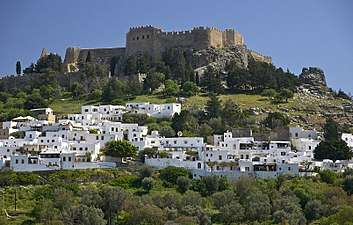
Acropolis
Above the modern town rises the acropolis of Lindos, a natural citadel which was fortified successively by the Greeks, the Romans, the Byzantines, the Knights of St John and the Ottomans. This makes the site difficult to excavate and interpret archaeologically. The acropolis has views of the surrounding harbours and coastline.
On the acropolis of Lindos today parts of the following buildings may still be seen:
- The Doric Temple of Athena Lindia, dating from about 300 BC, built on the site of an earlier temple. Inside the temple is the table of offerings and the base of the cult statue of Athena.
- The Propylaea of the Sanctuary, also dating from the 4th century BC. A monumental staircase leads to a D-shaped stoa and a wall with five door openings.
- The Hellenistic stoa with lateral projecting wings, dating from about 200 BC. The stoa was 87 metres long and consisted of 42 columns.
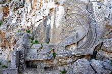
- The well-known relief of a Rhodian trireme (warship) cut into the rock at the foot of the steps leading to the acropolis. On the bow stood a statue of General Hagesander, the work of the sculptor Pythokritos. The relief dates from about 180 BC.
- The Hellenistic staircase (2nd century BC) leading to the main archaeological area of the acropolis.
- Remains of a Roman temple, possibly dedicated to the Emperor Diocletian and dating from about 300 AD.
- The Acropolis is surrounded by a Hellenistic wall contemporary with the Propylaea and the stairway leading to the entrance to the site. A Roman inscription says that the wall and square towers were repaired at the expense of P Aelius Hagetor, the priest of Athena in the 2nd century AD.
- The Castle of the Knights of St John, built some time before 1317 on the foundations of older Byzantine fortifications. The walls and towers follow the natural conformation of the cliff. A pentagonal tower on the south side commanded the harbour, the settlement and the road from the south of the island. There was a large round tower on the east facing the sea and two more, one round and the other on a corner, on the northeast side of the enceinte. Today one of the towers at the southwest corner and one to the west survive.
- The Greek Orthodox Church of St John, dating from the 13th or 14th century and built on the ruins of a previous church, which may have been built as early as the 6th century.
Some scenes of the well-known film, The Guns of Navarone, were filmed here.
Gallery (Acropolis)
 View to the Acropolis
.jpg) Staircase of the Propylaea
Staircase of the Propylaea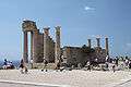 Doric temple of Athena Lindia
_01.jpg) Columns of the Hellenistic stoa
Columns of the Hellenistic stoa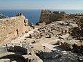 View of the summit of the Acropolis
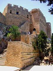 Medieval gate of the Acropolis
 Church of St. John on the Acropolis
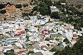 Panoramic view
Excavations

Excavations were carried out at Lindos in the years 1900 to 1914 by the Carlsberg Institute of Denmark, directed by K.F. Kinch and Christian Blinkenberg. The acropolis site was excavated down to bedrock and the foundations of all the buildings were uncovered.
During the Italian occupation of the island (1912–1945) major restoration work was carried out on the Lindos acropolis, but it was poorly done and was harmful to the historic record. The north-east side of the Temple of Athena was restored. The monumental staircase to the propylaea was rebuilt and many of the columns of the Hellenistic stoa were re-erected. Large surfaces were covered with concrete. Bases and inscribed blocks were taken from their locations and placed along the restored walls.
Judged by modern standards, this work took insufficient note of the evidence available from the excavations and in its methods did damage to the remains themselves. In recent years Greek and international archaeologists under the supervision of the Greek Ministry of Culture have been working to restore and protect the ancient buildings on the site.
Climate
Lindos has a very mild climate and according to the National Observatory of Athens station it registers a mean annual temperature of 21.8 °C.
| Climate data for Lindos (2014–2018). | |||||||||||||
|---|---|---|---|---|---|---|---|---|---|---|---|---|---|
| Month | Jan | Feb | Mar | Apr | May | Jun | Jul | Aug | Sep | Oct | Nov | Dec | Year |
| Average high °C (°F) | 16.0 (60.8) |
17.3 (63.1) |
19.1 (66.4) |
22.5 (72.5) |
26.1 (79) |
31.7 (89.1) |
35.3 (95.5) |
35.1 (95.2) |
31.5 (88.7) |
26.6 (79.9) |
21.7 (71.1) |
18.1 (64.6) |
25.1 (77.2) |
| Daily mean °C (°F) | 13.2 (55.8) |
14.7 (58.5) |
16.3 (61.3) |
19.0 (66.2) |
22.5 (72.5) |
27.8 (82) |
31.3 (88.3) |
31.4 (88.5) |
27.9 (82.2) |
23.4 (74.1) |
18.9 (66) |
15.4 (59.7) |
21.8 (71.2) |
| Average low °C (°F) | 10.6 (51.1) |
12.0 (53.6) |
13.5 (56.3) |
15.5 (59.9) |
18.9 (66) |
23.8 (74.8) |
27.3 (81.1) |
27.7 (81.9) |
24.3 (75.7) |
20.3 (68.5) |
16.0 (60.8) |
12.6 (54.7) |
18.5 (65.3) |
| Average rainfall mm (inches) | 60.1 (2.366) |
62.8 (2.472) |
41.8 (1.646) |
4.7 (0.185) |
19.7 (0.776) |
1.3 (0.051) |
0.05 (0.002) |
0.0 (0) |
11.2 (0.441) |
19.6 (0.772) |
42.7 (1.681) |
42.3 (1.665) |
306.1 (12.051) |
| Source: Meteoclub.gr[4] | |||||||||||||
Gallery (town)
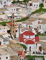 The Byzantine Panagia church with the belltower is located in the centre of the village
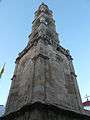 The belltower
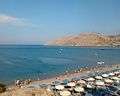 The beach of Vliha Bay
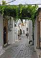 View of a street
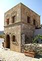 Old house
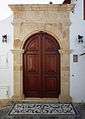 Door at the town
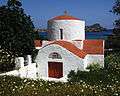 The 13th century Greek Orthodox Church of St Peter
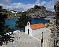 St Paul's church is now popular as a wedding chapel
 Beach of Lindos
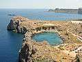 St Paul's Bay, where it is reported the apostle landed during a storm
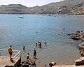 View of Vliha bay
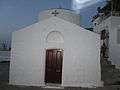
Notable people
- Chares of Lindos, sculptor, constructed the Colossus of Rhodes
- Cleobulus of Lindos
- Patriarch Joannicius II of Constantinople
- Ioannis Zigdis (1913–1997), politician and economist
See also
References
- 1 2 "Απογραφή Πληθυσμού - Κατοικιών 2011. ΜΟΝΙΜΟΣ Πληθυσμός" (in Greek). Hellenic Statistical Authority.
- ↑ Kallikratis law Greece Ministry of Interior (in Greek)
- ↑ "Population & housing census 2001 (incl. area and average elevation)" (PDF) (in Greek). National Statistical Service of Greece. Archived from the original (PDF) on 2015-09-21.
- ↑ Κλιματικά δεδομένα Πειραιά (in Greek). Meteoclub. Retrieved 12 April 2018.
External links
| Wikimedia Commons has media related to Lindos. |
| Wikivoyage has a travel guide for Lindos. |