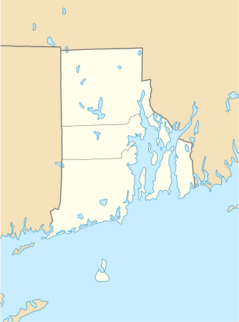
Aquidneck Island
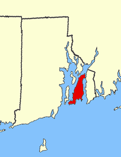 Aquidneck Island highlighted in red | |
 Aquidneck Island Rhode Island | |
| Geography | |
|---|---|
| Location | Narragansett Bay |
| Coordinates | 41°33′20″N 71°15′53″W / 41.55556°N 71.26472°W |
| Area | 37.8 sq mi (98 km2) |
| Length | 15 mi (24 km) |
| Width | 5 mi (8 km) |
| Highest elevation | 260 ft (79 m) |
| Highest point | Slate Hill |
| Administration | |
|
United States | |
| State | Rhode Island |
| County | Newport County |
| Largest settlement | Newport (pop. 24,672) |
| Demographics | |
| Population | 58,211 (2010) |
| Pop. density | 621.12 /km2 (1,608.69 /sq mi) |
Aquidneck Island, officially Rhode Island, is an island in Narragansett Bay and in the State of Rhode Island and Providence Plantations, which is partially named after the island. The total land area is 97.9 km2 (37.8 sq mi), which makes it the largest island in the bay. The 2000 United States Census reported its population as 60,870.
Aquidneck Island is home to three towns, from north to south: Portsmouth, Middletown, and Newport.
Etymology
"Aquidneck" is derived from the Narragansett name for the island aquidnet.[1] Roger Williams was an authority on the Narragansett language, but he stated that he never learned the word's meaning.[2] It is unclear how it came to be known as Rhode Island, but the earliest known use of the name was in 1637 by Roger Williams, and it was officially applied to the island in 1644: "Aquethneck shall be henceforth called the Ile of Rods or Rhod-Island." The name "Isle of Rodes" is used in a legal document as late as 1646.[3][4]
In 1524, explorer Giovanni da Verrazzano noted the presence of an island near the mouth of Narragansett Bay which he likened to the Greek island of Rhodes. It is uncertain which island he was referring to, but the colonists who settled the area decided to refer to Aquidneck as Rhode Island. Another popular origin theory is based on the fact that Adriaen Block passed by Aquidneck Island during his 1614 expedition, described in a 1625 account of his travels as "an island of reddish appearance" (in 17th century Dutch een rodlich Eylande).[5] Dutch maps from as early as 1659 call it "Roode Eylant" or Red Island. Historians have theorized that it was named by the Dutch (possibly by Adriaen Block himself) for either the red autumn foliage or red clay on portions of the shore.[6][7]
In 1644, the settlements on Rhode Island (Portsmouth and Newport) united with Providence Plantations and Warwick to form the Colony of Rhode Island and Providence Plantations and, eventually, the State of Rhode Island and Providence Plantations. The entire state is now commonly referred to as Rhode Island, and the official name of Aquidneck Island is still "Rhode Island." The U.S. Board on Geographic Names addressed the issue in 1930 by using both names of the island on its maps. By 1964, the board decided that having two names was confusing, and "Rhode Island" was used exclusively as the official name. Attempts to change the official name to "Aquidneck Island" have been made as recently as 2004, but all of these have failed.[8][9]
History
English colonists first settled on present-day Aquidneck Island in 1638 in the region that the Indians called "Pocasset" (meaning "where the stream widens"), the northern part of Portsmouth. They engaged Roger Williams in 1638 to negotiate the terms of their purchase of the island from a Narragansett sachem named Miantonomi. These settlers included William Coddington, Anne and William Hutchinson, Philip Sherman, William Dyer, John Coggeshall, Nicholas Easton, William Brenton, John Clarke, and Richard Maxson (Maggsen).[10] They bought the island for 40 fathoms of white wampum, 20 hoes, 10 coats for the resident Indians, and 5 more fathoms of wampum for the local sachem,[11] and Narragansett Sachems Canonicus and his nephew Miantonomi signed a deed for it. These first settlers founded Pocasset, but William Coddington chose Newport for a settlement the following spring (1639) because of its excellent harbor, and some of the settlers followed him there.
Aquidneck Island was occupied by the British during the American Revolution from 1776–79. The Battle of Rhode Island on August 29, 1778 was an unsuccessful attempt by the Continental Army under command of Major General John Sullivan to drive out the British and retake the strategic port city of Newport.
Schools
The island is home to Salve Regina University, the Naval War College, the Newport campus of the Community College of Rhode Island, and International Yacht Restoration School.
It is also home to two well known private boarding schools St. George's School in Middletown and Portsmouth Abbey School in Portsmouth. The island also contains numerous public and private primary and secondary schools as a part of the school systems of Newport, Middletown and Portsmouth.
Bridges
The Claiborne Pell Newport Bridge (1969) connects Aquidneck Island to Jamestown on nearby Conanicut Island in Narragansett Bay, and subsequently to the mainland on the western side of the bay.
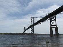
looking toward Aquidneck Island
The Mount Hope Bridge (1929), adjacent to Bristol Ferry and Common Fence Point, connects the northern side of Aquidneck Island in Portsmouth to the mainland at Bristol.
The Sakonnet River Bridge (2012) in Portsmouth, adjacent to Common Fence Point, connects the northeastern side of the island to the mainland at Tiverton over the Sakonnet River, a narrow saltwater strait. It is a replacement for a bridge of the same name built in 1956.
South of the Sakonnet River Bridge and its predecessor, in the area known as The Hummocks and Island Park, is the site of the Stone Bridge, built in 1907 on the site of an earlier wooden bridge and destroyed by Hurricane Carol in 1954.
The bridges replaced long-running ferries to the mainland and other Narragansett Bay islands.
References
- ↑ Henry Schoolcraft, The American Indians (1851)
- ↑ Henry Schoolcraft's History of American Indians. 1851.
- ↑ Office of the Secretary of State: A. Ralph Mollis: State Library Rhode Island Office of the Secretary of State, archived November 17, 2010 from the original
- ↑ Staples, Hamilton B. (1882). "Origins of the Names of the State of the Union". Proceedings of the American Antiquarian Society. 68. p. 368.
- ↑ Nieuwe Wereldt ofte Beschrijvinghe van West-Indien, uit veelerhande Schriften ende Aen-teekeningen van verscheyden Natien (Leiden, Bonaventure & Abraham Elseviers, 1625). An English translation of the relevant text: Documentary History of Rhode Island (1916)
- ↑ Elisha Potter, 1835. The Early History of Narragansett. Collections of the Rhode-Island Historical Society, v3.
- ↑ Samuel G. Arnold, History of Rhode Island (1859). p. 70
- ↑ USGS Feature Detail Report for: Rhode Island
- ↑ Mark Patinkin: According to the map, there is no Aquidneck Island
- ↑ Providence, RI: The Islands Archived 2010-04-10 at the Wayback Machine.
- ↑ Rhode Island Geography
Further reading
- Aquidneck Indian Council, "A Brief History of Aquidneck Island"
- Denlson, Frederic (1879). Narragansett Sea and Shore. Providence, RI: J.A. & R.A. Reid.
- Seavey, George L. Rhode Island's Coastal Natural Areas.
- "Aquidneck added to 2011 Map of Rhode Island". The Providence Journal, Monday, July 18, 2011, page A5.
External links

| Islands |  | |
|---|---|---|
| Major rivers | ||
| Cities & towns | ||
| Bridges | ||
Coordinates: 41°33′20″N 71°15′53″W / 41.55556°N 71.26472°W
| Authority control |
|---|