Adam's Bridge
Coordinates: 9°07′16″N 79°31′18″E / 9.1210°N 79.5217°E
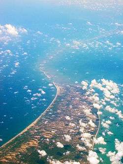
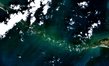
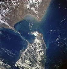
Adam's Bridge (ātām pālam; Sinhala: adamgay palama), also known as Rama's Bridge or Rama Setu (Irāmar pālam, Sanskrit: rāmasetu),[1] is a chain of limestone shoals, between Pamban Island, also known as Rameswaram Island, off the south-eastern coast of Tamil Nadu, India, and Mannar Island, off the north-western coast of Sri Lanka. Geological evidence suggests that this bridge is a former land connection between India and Sri Lanka.[2]
The bridge is 30 km (20 mi) long and separates the Gulf of Mannar (south-west) from the Palk Bay (northeast).[3] Some of the sandbanks are dry and the sea in the area is very shallow, being only 1 to 10 metres (3 to 30 ft) deep in places, which hinders navigation.[2] It was reportedly passable on foot up to the 15th century until storms deepened the channel: temple records seem to say that Adam's Bridge was completely above sea level until it broke in a cyclone in 1480.[4]
Name
The bridge was first mentioned in the ancient Indian Sanskrit epic Ramayana of Valmiki.[5] The name Rama's Bridge or Rama Setu (Sanskrit; setu: bridge) refers to the bridge built by the Vanara (ape men) army of Rama in Hindu theology with instructions from Nala,[6] which he used to reach Lanka and rescue his wife Sita from the Rakshasa king, Ravana.[5] The Ramayana attributes the building of this bridge to Rama in verse 2-22-76, naming it as Setubandhanam, a name that persists until today.[7]
The sea separating India and Sri Lanka is called Sethusamudram meaning "Sea of the Bridge". Maps prepared by a Dutch cartographer in 1747 show this area as Ramancoil, a colloquial form of the Tamil Raman Kovil (or Rama's Temple).[8] Another map of Mughal India prepared by J. Rennel in 1788 retrieved from the same library called this area as "the area of the Rama Temple", referring to the temple dedicated to Rama at Rameswaram.[9] Many other maps in Schwartzberg's historical atlas[10][11] and other sources such as travel texts by Marco Polo call this area by various names such as Sethubandha and Sethubandha Rameswaram.[12][13][14][15][16]
The western world first encountered it in "historical works in the 9th century" by Ibn Khordadbeh in his Book of Roads and Kingdoms (c. 850), referring to it is Set Bandhai or "Bridge of the Sea".[17] Later, Alberuni described it. The earliest map that calls this area by the name Adam's bridge was prepared by a British cartographer in 1804.[2][5][18] Some early Islamic sources refer to a mountain in Sri Lanka as Adam's Peak, where Adam supposedly fell to earth and describes Adam as crossing from Sri Lanka to India on what became known as Adam's Bridge.[19]
Location
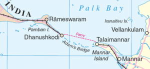
The bridge starts as a chain of shoals from the Dhanushkodi tip of India's Pamban Island and ends at Sri Lanka's Mannar Island. Pamban Island is semi-connected to the Indian mainland by 2 km long Pamban Bridge. Mannar Island is connected to mainland Sri Lanka by a causeway. The border between India and Sri Lanka is said to pass across one of the shoals constituting one of the shortest land borders in the world.[20] Ramasetu and neighbouring areas like Rameswaram, Dhanushkodi, Devipattinam and Thirupullani are mentioned in the context of various legends in Ramayana.[21][22][23]
Transportation and navigation
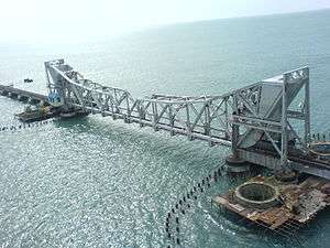
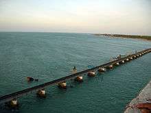
Pamban Island (Tamil Nadu, India) with its small port of Rameswaram is about 2 km from mainland India. The Pamban Bridge crossing the Pamban channel links Pamban Island with mainland India. It refers to both: a road bridge and a cantilever railway bridge. Small boats would go below the 2,065-metre-long (6,775 ft) road bridge, and the railway bridge would open up.
The problem in navigation exists because big ships cannot travel in the shallow waters of the Pamban channel. Dredging in this channel would cost more than dredging a channel in the Rama Setu area, where the waters are comparatively deep and less earth would have to be dredged. Hence, in 2005, the Government of India approved a multi-million dollar Sethusamudram Shipping Canal Project that aims to create a ship channel across the Palk Bay cutting across Rama Setu.[24] Various organizations have opposed the project based on religious, economic and environmental grounds and have sought the implementation of one of the alternative alignments considered during the earlier stages of the discussion.
A ferry service linked Dhanushkodi in India with Talaimannar in Sri Lanka. The service was part of the Indo-Ceylon Railway service during the British Rule. One could buy a railway ticket from Chennai to Colombo, whereby people travelled by rail from Chennai to Pamban island, go by ferry to Talaimannar, and then go again by rail to Colombo. In 1964, a cyclone completely destroyed Dhanushkodi, as a train was about to enter the station. The tracks and the pier were heavily damaged along the shores of Palk Bay and Palk Strait. Dhanushkodi was not rebuilt and the train then finished its journey at Rameswaram. There was a small ferry service from there to Talaimannar, but it was suspended around 1982 because of the fighting between Sri Lankan government forces and the separatist LTTE.
Geological evolution
Considerable diversity of opinion and confusion exists about the nature and origin of this structure. In the 19th century, two major theories were prominent in explaining the structure. One considered it to be formed by the process of accretion and rising of the land, while the other surmised that it was established by the breaking away of Sri Lanka from the Indian mainland.[25] The friable calcareous ridges later broke into large rectangular blocks, which perhaps gave rise to the belief that the causeway is an artificial construction.[26]
According to V. Ram Mohan of the Centre of Natural Hazards and Disaster Studies of the University of Madras, "reconstruction of the geological evolution of the island chain is a challenging task and has to be carried out based on circumstantial evidence".[27] The lack of comprehensive field studies explains many of the uncertainties regarding the nature and origin of Adam's Bridge, which mostly consists of a series of parallel ledges of sandstone and conglomerates that are hard at the surface and grow coarse and soft as they descend to sandy banks.[28]
Studies have variously described the structure as a chain of shoals, coral reefs, a ridge formed in the region owing to thinning of the earth's crust, a double tombolo,[29] a sand spit, or barrier islands. One account mentions that this landform was formerly the world's largest tombolo that split into a chain of shoals by a slight rise in mean sea level a few thousand years ago.[30]
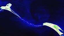
Based on satellite remote sensing data, but without actual field verification, the Marine and Water Resources Group of the Space Application Centre (SAC) of the Indian Space Research Organisation (ISRO) concludes that Adam's Bridge comprises 103 small patch reefs lying in a linear pattern.[28] The feature consists of the reef crest (flattened, emergent, especially during low tides, or nearly emergent segment of a reef), sand cays (accumulations of loose coral sands and beach rock) and intermittent deep channels. The coral reefs are variously designated by other studies as ribbon and atoll reefs.[31]
The geological process that gave rise to this structure has been attributed in one study to crustal down warping, block faulting, and mantle plume activity[32] while another theory attributes it to continuous sand deposition and the natural process of sedimentation leading to the formation of a chain of barrier islands related to rising sea levels.[31] Another theory affirms that the origin and linearity of Adam's Bridge might be due to the old shoreline (implying that the two landmasses of India and Sri Lanka were once connected) from which shoreline coral reefs developed.
Another study attributes the origin of the structure to longshore drifting currents which moved in an anticlockwise direction in the north and clockwise direction in the south of Rameswaram and Talaimannar. The sand could have been dumped in a linear pattern along the current shadow zone between Dhanushkodi and Talaimannar with the later accumulation of corals over these linear sand bodies.[33] In a diametrically opposing view, another group of geologists propose a crustal thinning theory, block faulting and a ridge formed in the region owing to thinning and asserts that development of this ridge augmented the coral growth in the area and in turn coral cover acted as a `sand trapper'.[31]
The tombolo model affirms a constant sediment source and a high unidirectional or bi-directional (monsoonal) longshore current. One study tentatively concludes that there is insufficient evidence to indicate eustatic emergence and that the raised reef in southern India probably results from a local uplift.[34] Other studies also conclude that during periods of lowered sea level over the last 100,000 years, Adam's Bridge has provided an intermittent land connection between India and Sri Lanka, which according to famous ornithologists Sidney Dillon Ripley and Bruce Beehler supports the vicariance model for speciation in some birds of the Indian Subcontinent.[35]
Age
The studies under "Project Rameswaram" of the Geological Survey of India (GSI), which included dating of corals, indicate Rameswaram Island evolved beginning 125,000 years ago. Radiocarbon dating of samples in this study suggests the domain between Rameswaram and Talaimannar may have been exposed sometime between 7,000 and 18,000 years ago.[31] Thermoluminescence dating by GSI concludes that the sand dunes between Dhanushkodi and Adam's Bridge started forming about 500–600 years ago.[31]
An investigation by the Centre for Remote Sensing (CRS) of Bharathidasan University, Tiruchi, led by Professor S.M. Ramasamy dates the structure to 3,500 years.[36] In the same study, carbon dating of some ancient beaches between Thiruthuraipoondi and Kodiyakarai shows the Thiruthuraipoondi beach dates back to 6,000 years and Kodiyakarai around 1,100 years ago. Another study suggests that the appearance of the reefs and other evidence indicate their recency, and a coral sample gives a radiocarbon age of 4,020±160 years BP.[31]
Early surveys and dredging efforts
Due to shallow waters, Adam's bridge presents a formidable hindrance to navigation through the Palk Strait. Though trade across the India-Sri Lanka divide has been active since at least the first millennium BC, it was limited to small boats and dinghies. Larger ocean-going vessels from the West have had to navigate around Sri Lanka to reach India's eastern coast.[37] Eminent British geographer Major James Rennell, who surveyed the region as a young officer in the late 18th century, suggested that a "navigable passage could be maintained by dredging the strait of Ramisseram [sic]". However, little notice was given to his proposal, perhaps because it came from "so young and unknown an officer", and the idea got revived only 60 years later.
In 1823, Sir Arthur Cotton (then an Ensign), was assigned to survey the Pamban channel, which separates the Indian mainland from the island of Rameswaram and forms the first link of Adam's Bridge. Geological evidence indicates that a land connection bridged this in the past, and some temple records suggest that violent storms broke the link in 1480. Cotton suggested that the channel could be dredged to enable passage of ships, but nothing was done until 1828 when Major Sim directed the blasting and removal of some rocks.[38][39]
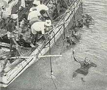
A more detailed marine survey of Adam's Bridge was undertaken in 1837 by Lieutenants F. T. Powell, Ethersey, Grieve, and Christopher along with draughtsman Felix Jones, and operations to dredge the channel were recommenced the next year.[38][40] However, these and subsequent efforts in the 19th century did not succeed in keeping the passage navigable for any vessels except those with a light draft.[2]
Sethusamudram shipping canal project

The government of India constituted nine committees before independence, and five committees since then, to suggest alignments for a Sethusamudram canal project. Most of them suggested land-based passages across Rameswaram island, and none recommended alignment across Adam's Bridge.[41] The Sethusamudram project committee in 1956 also strongly recommended to the Union government to use land passages instead of cutting Adam's Bridge because of the several advantages of land passage.[42]
In 2005, the Government of India approved a multi-million dollar Sethusamudram Shipping Canal Project that aims to create a ship channel across the Palk Strait by dredging the shallow ocean floor near Dhanushkodi. The channel is expected to cut over 400 km (nearly 30 hours of shipping time) off the voyage around the island of Sri Lanka. This proposed channel's current alignment requires dredging through Adam's Bridge.
Indian political parties including the Bharatiya Janata Party (BJP), All India Anna Dravida Munnetra Kazhagam (AIADMK), Rashtriya Janata Dal (RJD), Janata Dal (Secular) (JD(S)) and some Hindu organisations oppose dredging through the shoal on religious grounds. The contention is that Adam's Bridge is identified popularly as the causeway described in the Ramayana. The political parties and organizations suggest alternate alignment for the channel that avoids damage to Adam's Bridge.[43][44] The then state and central governments opposed such changes, with the Union Shipping Minister T. R Baalu, who belongs to the Dravida Munnetra Kazhagam and a strong supporter of the project maintaining that the current proposal was economically viable and environmentally sustainable and that there were no other alternatives.[45][46][47]
Opposition to dredging through this causeway also stems from concerns over its impact on the area's ecology and marine wealth, potential loss of thorium deposits in the area, and increased risk of damage due to tsunamis.[48] Some organisations completely oppose this project on economic and environmental grounds and claim that proper scientific studies were not conducted before undertaking this project.[49]
Disputed origins
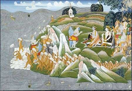
Certain historical inscriptions, old travel guides, old dictionary references and some old maps have been cited to support a religious and geographical belief that this is an ancient man-made bridge. In the Hindu epic, Ramayana, the bridge was created by Rama and Lakshmana with the assistance of Hanuman and the Vanara army to reach Lanka to find Rama's wife Sita who had been kidnapped by Ravana. In 2007, the Sri Lankan Tourism Development Authority sought to promote religious tourism from Hindu pilgrims in India by including the phenomenon as one of the points on its "Ramayana Trail", celebrating the legend of Prince Rama. Some Sri Lankan historians have condemned the undertaking as "a gross distortion of Sri Lankan history".[50] Vaishnava News Network and some other U.S.-based news services claimed to have found the remains of the bridge built by Rama and his Vanara army as narrated in Ramayana. Based on a study of 2002 NASA satellite images, they contended it was not a natural formation, but a human-made structure.[51] NASA distanced itself from the claims saying that the images reveal nothing more than a 30-km-long, naturally occurring chain of sandbanks.[52] It also clarified that "The images reproduced on the websites may well be ours, but their interpretation is certainly not ours. [...] Remote sensing images or photographs from orbit cannot provide direct information about the origin or age of a chain of islands, and certainly, cannot determine whether humans were involved in producing any of the patterns seen."[52]
In 2003, a team led by Professor S.M. Ramasamy, Centre for Remote Sensing (CRS), Bharathidasan University, Tiruchi said that the land/beaches between Ramanathapuram and Pamban were formed due to the longshore drifting currents. About 3,500 years ago, the currents moved in an anti-clockwise direction in the north and clockwise direction in the south of Rameswaram and Talaimannar. The team suggested that "as the carbon dating of the beaches roughly matches the dates of Ramayana, its link to the epic needs to be explored".[53] A former director of the Geological Survey of India, S. Badrinarayanan, said that such a natural formation would be impossible due to the presence of a loose sand layer under corals for the entire stretch. Corals typically form above rocks.[54][55] He suggests that a thorough analysis was not conducted by the Geological Survey of India before undertaking the SSCP project.
The Archaeological Survey of India and the government of India informed the Supreme Court of India in a 2007 affidavit that there was no historical proof of the bridge being built by Rama.[56] In a 2008 court case, a spokesman for the government stated the bridge was destroyed by Rama according to the scriptures,[57] this claim has been rejected by other observers.[58] In connection with the canal project, the Madras High Court in its verdict stated that the Rama Sethu is a man-made structure.[59]
In 2007, a publication of the National Remote Sensing Agency said that the structure "may be man-made".[60] The report from the Archaeological Survey of India found no evidence for it being man-made.[31]
See also
References
- ↑ also spelled Rama Setu, Ram Sethu, Ramasethu and variants.
- 1 2 3 4 "Adam's bridge". Encyclopædia Britannica. 2007. Archived from the original on 13 January 2008. Retrieved 2007-09-14.
- ↑ map
- ↑ Garg, Ganga Ram (1992). "Adam's Bridge". Encyclopaedia of the Hindu World. A–Aj. New Delhi: South Asia Books. p. 142. ISBN 81-7022-374-1.
- 1 2 3 Room, Adrian (2006). Placenames of the World. McFarland & Company. p. 19. ISBN 0-7864-2248-3.
- ↑ GRIFFITH, M. A., RALPH T. H. "RÁMÁYAN OF VÁLMÍKI". Low Price Publications (January 1, 2003). Retrieved 23 June 2013.
- ↑ Valmiki Ramayan calls mythological bridge built by Lord Rama as Setubandhanam
- ↑ Jayalalitha quotes literary evidence for Ramar bridge
- ↑ Protests against shipping canal hot up
- ↑ Schwartzberg Atlas
- ↑ Schwartzberg Atlas
- ↑ Special Story Archived 5 May 2008 at the Wayback Machine.
- ↑ News Today – An English evening daily published from Chennai
- ↑ Scrap the shipping channel project Archived 21 April 2008 at the Wayback Machine.
- ↑ Marco Polo (1854) The travels of Marco Polo, the Venetian; "...the celebrated chain of sand-banks and coral reefs named Rama's or Adam's Bridge."
- ↑ Rajarajan, R.K.K. (2014) Reflections on "Rāma-Setu" in South Asian Tradition. The Quarterly Journal of the Mythic Society, Vol. 105.3: 1-14, ISSN 0047-8555. https://www.academia.edu/8779702/Reflections_on_R%C4%81ma-Setu_in_South_Asian_Tradition
- ↑ Horatio John Suckling, Ceylon: A General Description of the Island, Historical, Physical, Statistical, London (1876), p. 76.
- ↑ Ramar Sethu, a world heritage centre?
- ↑ Ricci, Ronit (2011). Islam Translated: Literature, Conversion, and the Arabic Cosmopolis of South and Southeast Asia. University of Chicago Press. p. 136. ISBN 9780226710884.
- ↑ Dhanuskodi: The Lost Land
- ↑
- ↑ "Madurai Travels – Rameswaram". Madurai.com. Retrieved 2010-07-16.
- ↑ P. S. Suresh Kumar (Jun 15, 2002). "Shattered in 1964, still remains so". The Hindu.
- ↑ "Sethusamudram ship canal project". India Environment Portal. Retrieved July 19, 2017.
- ↑ Tennent, James Emerson (1859). Ceylon: An Account of the Island Physical, Historical and Topographical. London: Longman, Green, Longman, and Roberts. p. 13.
- ↑ Suess, Eduard (1906). The Face of the Earth (Vol. II). Translated by Hertha B. C. Sollas. Oxford: Clarendon Press. pp. 512–513.
- ↑ "Ram Setu: Fact or fiction?". www.speakingtree.in. Retrieved 2017-12-14.
- 1 2 Bahuguna, Anjali; Nayak, Shailesh; Deshmukh, Benidhar (2003-12-01). "IRS views the Adams bridge (bridging India and Sri Lanka)". Journal of the Indian Society of Remote Sensing. 31 (4): 237–239. doi:10.1007/BF03007343. ISSN 0255-660X.
- ↑ "Double Tombolo reference by NASA". Archived from the original on 2 December 2007. Retrieved 21 October 2007.
- ↑ "Tombolo | geology". Encyclopedia Britannica. Retrieved 2017-12-14.
- 1 2 3 4 5 6 7 "Myth vs Science". www.frontline.in. Retrieved 2017-12-13.
- ↑ Crustal downwarping, block faulting, and mantel plume activity view
- ↑ Ramasamy, S.M. (2003). "Facts and myths about Adam's Bridge" (PDF). GIS@development.
- ↑ D. R. Stoddart; C. S. Gopinadha Pillai (1972). "Raised Reefs of Ramanathapuram, South India". Transactions of the Institute of British Geographers. 56 (56): 111–125. doi:10.2307/621544. JSTOR 621544.
- ↑ Ripley, S. Dillon; Beehler, Bruce M. (November 1990). "Patterns of Speciation in Indian Birds". Journal of Biogeography. Journal of Biogeography. 17 (6): 639–648. doi:10.2307/2845145. JSTOR 2845145.
- ↑ CRS study point Ram Setu to 3500 years old
- ↑ Francis, Jr., Peter (2002). Asia's Maritime Bead Trade: 300 B.C. to the Present. University of Hawaii Press. ISBN 0-8248-2332-X.
- 1 2 Hunter, Sir William Wilson (1886). The Imperial Gazetteer of India. Trübner & co. pp. 21–23.
- ↑ Digby, William (1900). General Sir Arthur Cotton, R. E., K. C. S. I.: His Life and Work. Hodder & Stoughton. pp. 15–16.
- ↑ Dawson, Llewellyn Styles (1885). Memoirs of hydrography. Keay. p. 52. ISBN 0-665-68425-8.
- ↑ Sethusamudram Corporation Limited–History Archived 14 October 2007 at the Wayback Machine.
- ↑ "Use land based channel and do not cut through Adam bridge:Sethu samudram project committee report to Union Government". 30 September 2007. Archived from the original on 13 October 2007. Retrieved 15 October 2007.
"In these circumstances we have no doubt, whatever that the junction between the two sea should be effected by a Canal; and the idea of cutting a passage in the sea through Adam's Bridge should be abandoned.
- ↑ "Ram Setu a matter of faith, needs to be protected: Lalu". NewKerela.com. 21 September 2007. Retrieved 2007-09-24.
- ↑ "Rama is 'divine personality' says Gowda". MangaoreNews.com. 22 September 2007. Archived from the original on 21 April 2008. Retrieved 2007-09-24.
- ↑ "IndianExpress.com–Sethu: DMK chief sticks to his stand". Archived from the original on 21 April 2008. Retrieved 8 February 2016.
- ↑ Latest India News @ NewKerala.Com, India
- ↑ "indianexpress.com". Archived from the original on 21 April 2008. Retrieved 8 February 2016.
- ↑ "Thorium reserves to be disturbed if Ramar Sethu is destroyed". The Hindu. 5 August 2007. Archived from the original on 12 October 2007. Retrieved 2007-09-24.
- ↑ Karunanidhi or T R Baalu's arguments are not based on scientific studies claims coastal action network convenor
- ↑ Kumarage, Achalie (23 July 2010). "Selling off the history via the 'Ramayana Trail'". Daily Mirror. Colombo: Wijeya Newspapers Ltd. Archived from the original on 25 July 2010. Retrieved 23 July 2010.
the Tourism Authority is imposing an artificial [history] targeting a small segment of Indian travellers, specifically Hindu fundamentalists...
- ↑ "Hanuman bridge is myth: Experts". Times of India. 19 October 2002. Retrieved 2012-01-06.
- 1 2 Kumar, Arun (14 September 2007). "Space photos no proof of Ram Setu: NASA". Hindustan Times. Archived from the original on 22 January 2008. Retrieved 2007-09-18.
"The mysterious bridge was nothing more than a 30 km long, naturally occurring chain of sandbanks called Adam's bridge", [NASA official Mark] Hess had added. "NASA had been taking pictures of these shoals for years. Its images had never resulted in any scientific discovery in the area.
- ↑ "Rama's bridge is only 3,500 years old: CRS". Indian Express. 2 February 2003. Retrieved 2007-09-18.
- ↑ "Debate shifted over Ram from Ram Sethu". indianewstrack.com. 15 September 2007. Retrieved 2007-09-18.
- ↑ Ram sethu should be manmade says former Geological survey of India director
- ↑ No evidence to prove existence of Ram, Centre to SC
- ↑ Ram himself destroyed Setu, govt tells SC
- ↑ "Because it is Ram Setu and not Nehru bridge".
- ↑ Ram Sethu Timeline
- ↑ "Ram Sethu 'man-made', says government publication". Sify News. 8 December 2007. Archived from the original on 20 December 2007.
External links
| Wikimedia Commons has media related to Adam's Bridge. |