Nógrád
| Nógrád | |
|---|---|
 Nógrád Location of Nógrád | |
| Coordinates: 47°54′17″N 19°03′06″E / 47.90482°N 19.05157°ECoordinates: 47°54′17″N 19°03′06″E / 47.90482°N 19.05157°E | |
| Country |
|
| County | Nógrád |
| Area | |
| • Total | 29.52 km2 (11.40 sq mi) |
| Population (2004) | |
| • Total | 1,573 |
| • Density | 53.28/km2 (138.0/sq mi) |
| Time zone | UTC+1 (CET) |
| • Summer (DST) | UTC+2 (CEST) |
| Postal code | 2642 |
| Area code(s) | 35 |
- For the county, see Nógrád County.
Nógrád (Russian: Новгород, Novgorod-Ugorsky;[1][2] German: Neuburg; Slovak: Novohrad) is a village in Nógrád County, Hungary.
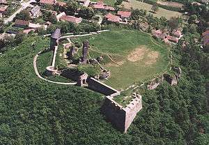
Nógrád, castle from a bird's eye view
Etymology
The name comes from Slavic Novgrad ("New Castle") from which evolved Slovak Novohrad (with the same meaning) and Hungarian Nógrád. 1138/1329 civitas Naugrad, around 1200 castrum Nougrad, 1217 castrum de Nevgrad.[3] The village (1405 villa Newgrad) and the county was named after the castle.
References
- ↑ Vernadsky, V. Voice from the Hungarian Ruthenia. "Russkaya Mysl". 1880
- ↑ Pogodin, A. Ruthenia Abroad. "Soikin Publishing". Petrograd 1915
- ↑ Branislav, Varsik (1994). "Osídlenie Novohradu a Ipeľskej kotliny vo svetle miestnych názvov". Kontinuita medzi veľkomoravskými Slovienmi a stredovekými severouhorskými Slovanmi (Slovákmi) (in Slovak). Veda. p. 115. ISBN 80-224-0175-7.
External links
- Street map (in Hungarian)
This article is issued from
Wikipedia.
The text is licensed under Creative Commons - Attribution - Sharealike.
Additional terms may apply for the media files.