List of cycle routes in London
This article provides a list of cycle routes in the Greater London area that have been waymarked with formal numbered route signage.
The routes include Cycle Superhighways, Quietways and the older London Cycle Network Plus, all designated by local government body Transport for London (TfL), and National Cycle Network routes designated by sustainable transport charity Sustrans.
Note: not all these routes are dedicated 'traffic free' cycle tracks: most of them also include ordinary roads shared with motor traffic and footpaths shared with pedestrians.
National and international routes
National Cycle Network routes
The sustainable transport charity Sustrans describe their National Cycle Network (NCN) as "a network of safe traffic-free paths and quiet on-road cycling" that "criss-cross the country, linking up villages, towns and cities".[1] Several of these NCN routes pass through London. NCN routes are signed with white lettering on a blue background, with route numbers having a red background.[2]
| Route Number | National Route Description | Route through London | Notes | OpenStreetMap reference |
|---|---|---|---|---|
| NCN1 | Shetland to Dover | Waltham Abbey (town) along the River Lea via Tottenham to the Isle of Dogs, through Greenwich Foot Tunnel, Thames Path from Greenwich to Dartford | Also serves as part of international route EV2 (see below), and was London Cycle Network + route LCN1. | |
| NCN12 | Enfield Lock to Spalding, Lincolnshire [3] | Enfield Lock to Hadley Wood | Currently under development as the "Enfield Island Village to Hadley Wood Greenway" [4] | |
| NCN125[5] | - | Dartford: River Thames to Brooklands Lake along the River Darent | Opened in 2012. | map |
| NCN13 | London to Norwich | Tower Bridge - Barking (Royal Docks) – Rainham - Purfleet | shares part of its route with TfL Cycle Superhighway 3 | |
| NCN136 | — | Rainham to Noak Hill via Upminster | ||
| NCN162 | — | North London: Finsbury Park to Highbury Fields | Shares most of its route with the old LCN7 | |
| NCN177 | — | River Thames to South Coast in Kent | Currently open between Northfleet and Rochester, and between Downswood and the western edge of Mote Park. | map |
| NCN20 | London to Brighton | Wandle Trail from Wandsworth - Carshalton, then on to Coulsdon | The international Avenue Verte from London to Paris follows NCN20; TfL Quietway Q4 shares the route of NCN20 between Earlsfield and the Wandle Meadow Nature Park | |
| NCN208 | — | Raynes Park to Morden | ||
| NCN21 | London to Eastbourne | Waterlink Way from Greenwich - Lewisham - Catford – (Elmers End) – (New Addington) - Crawley | ||
| NCN4 | Fishguard to London | Thames Path between Greenwich and Windsor | Also serves as part of international route EV2 (see below), and was London Cycle Network + route LCN4. | |
| NCN425 | — | Burgess Park in Camberwell to Durand's Wharf in Rotherhithe | 8.1 km route built with a grant from the National Lottery |
Additionally, some portions of these NCN routes have also been co-opted by the European Cyclists' Federation as forming part of their international EuroVelo network:
- EV2_The_Capitals_Route which runs from Galway in Ireland to Moscow in Russia, follows the course of NCN4 along the River Thames from west London to Greenwich, and then NCN1 northwards to Harwich
Cycle Superhighways
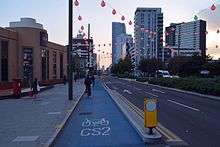
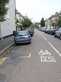
London's Cycle Superhighways are a set of Bike freeways, aimed principally at commuters and more experienced cyclists, providing faster and more direct radial routes between outer and central London.[6] In addition to dedicated route signage they are indicated on the ground by distinctive sky blue painted lanes.
History
London's Cycle Superhighways were first announced in 2008 by Mayor Ken Livingstone.[7] The original proposal consisted of 12 radial routes, with route numbers in 'clock face' fashion.[8] Although the scheme is coordinated centrally by TfL, it is implemented on the ground by London boroughs. This has led to several changes as the roll out continues, including cancellation of the original CS6 and CS12 routes[9] and addition of two 'North-South' and 'East-West' routes through central London, the latter dubbed the "Crossrail for Bikes".
Cycle Superhighway Routes
As of June 2018, TfL's website lists eight Cycle Superhighway routes.
| Name | Route | Comments | Map |
|---|---|---|---|
| CS1 | Tottenham to Liverpool Street (A10) | Was completed in April 2016.[10] Unlike the other Superhighways, this route is primarily non-segregated on quieter streets and is thus more similar to the Quietways. | map |
| CS2 | Stratford to Aldgate (A118 - A11) | Upgrade between Bow and Aldgate was completed in April 2016, with separated cycle tracks replacing cycle lanes along the majority of the route.[11] | map |
| CS3 | Barking to Tower Hill (A13 - A1202 - A3211 - Hyde Park - A402 - A4209) | map | |
| CS3 East-West[12] | Lancaster Gate to Tower Hill | Minor finishing works will continue until autumn 2018. Connects with CS3 at Tower Hill.
There are proposals to extend the East-West Cycle Superhighway further westwards to Acton,[13] via a future CS10 route. | map |
| CS5[14] | Oval to Pimlico (A202) | To be extended later to eventually run from Lewisham to Victoria (A20 - A202). | map |
| North-South (CS6)[15] | Elephant & Castle to Kings Cross | First section of the route opened in spring 2016 between Elephant and Castle and Stonecutter Street; opened fully in September 2018. The originally proposed CS6 route was to have run from Penge to the City. | map |
| CS7 | Merton to the City (A24 - A3) | map | |
| CS8 | Wandsworth to Westminster (A3 - A3205 - Vauxhall Cross) | map |
As of September 2018, the TfL website lists three more proposed new Cycle Superhighway routes that are progressing through public consultation and implementation by local borough councils.
Safety concerns
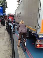
The initial implementation of the cycle superhighways drew criticism on safety grounds, with poor design at some junctions and insufficient segregation of cyclists from motor traffic. For instance in 2009 the London Cycling Campaign proposed a manifesto concerning safety, cycle priority and junction design along the Superhighways.[19] The former Mayor Boris Johnson declined to sign it, but said that TfL would take stakeholders' views into account.[20]
An unofficial 2012 photo journey with commentary along the super highways is available.[21]
In 2013, fatalities continued to draw criticism in the press, for instance urbanist and author Charles Montgomery, writing in The Guardian, described them as "inherently dangerous pieces of infrastructure... [that lead] cyclists directly into confrontation with other vehicles".[22] The junction at Bow roundabout (CS2) saw three cyclists killed in 2013[23] and the Mayor of Newham Sir Robin Wales made the decision to block the route from entering Newham on the grounds of cyclists' safety.
In 2015, noting that "around 85% of cyclist accidents happen at junctions", TfL announced several new junction design features that aimed to improve safety.[24]
In 2017 the London coroner called for an urgent review the "slippery" blue paint surface on the cycle superhighways, saying they may pose a death risk to users.[25]
Quietways
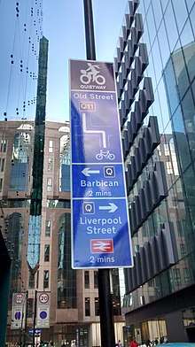
Unlike Cycle Superhighways which are intended to give cyclists a quicker way around London, Quietways, also promoted by Transport for London,[26] target less confident cyclists who want to use lower traffic routes, whilst also providing for existing cyclists who want to travel at a more gentle pace.
Routes are generally along back-streets, through parks, along waterways or tree-lined streets, and are designed to overcome barriers to cycling such as high volumes of traffic and unsafe crossings. The route numbers are shown in purple on signs and maps.
Quietway Routes
The first Quietway (Q1 from Waterloo to Greenwich) opened in June 2016;[27] the second (Q2 from Bloomsbury to Walthamstow) opened in August 2018.[28] As of August 2018, TfL's website listed twelve Quietway routes that were at least partially complete.[29]
| Name | Route | Boroughs | Comments | Map |
|---|---|---|---|---|
| Q1 | North section: (Gospel Oak - Kentish Town) - Bloomsbury - Holborn - Covent Garden;[30] South section: South Bank - Waterloo East station - Bermondsey - South Bermondsey station - Deptford station - Greenwich - (Falconwood - Bexleyheath) |
Camden, City of Westminster, Lambeth, Southwark, Lewisham, Greenwich, Bexley | North section: Covent Garden to Bloomsbury.[31] South section: South Bank to Greenwich; route is diverted around The Den on Millwall match days. |
Q1(N) Q1(S) map |
| Q2 | West section: East Acton - Wormwood Scrubs - Notting Hill - Bayswater - (Fitzrovia); East section: Bloomsbury - Angel - Canonbury - De Beauvoir Town - London Fields - Clapton - Lea Bridge - Walthamstow Wetlands - Walthamstow Central |
Hammersmith & Fulham, Kensington & Chelsea, City of Westminster, Camden, Islington, Hackney, Waltham Forest | West section: East Acton to Lancaster Gate[32][33][34] East section: Bloomsbury to Walthamstow. |
|
| Q3 | (Regent's Park) - Kilburn - Gladstone Park (Dollis Hill) | City of Westminster, Camden, Brent | Q3 map | |
| Q4 | Clapham Common to Wimbledon | Lambeth, Wandsworth, Merton | Shares the route of Sustrans NCN20 between Earlsfield and the Wandle Meadow Nature Park | Q4 map |
| Q5 | (Waterloo) - Oval - Clapham Common - (Tooting Bec Common - Streatham Common station - Norbury - Thornton Heath - Croydon) | Lambeth, Wandsworth, Croydon | The initial planned route between Norbury and Croydon has had to be redesigned due to issues along Norbury Avenue.[35] | Q5 map |
| Q6 | (Mile End - Old Ford - Victoria Park - Queen Elizabeth Olympic Park - Temple Mills) - Wanstead Flats - Valentines Park - Barkingside | Tower Hamlets, Hackney, London Legacy Development Corporation, Newham, Redbridge | Valentines Park is closed at night. Route will later be extended west to Aldgate and east to Hainault | Q6 map |
| Q7 | Elephant & Castle - Dulwich - Crystal Palace | Lambeth, Southwark | A further Q7 section in Westminster between Hyde Park and Camden has been proposed.[36] | Q7 map |
| Q11 | Southwark Bridge to Islington | City of London,[37] Islington, Hackney | Q11 map | |
| Q13 | Old Street to Broadway Market | Islington, Hackney[38] | Q13 map | |
| Q14 | Blackfriars - Tower Bridge Road - (Canada Water - Greenwich) - Thamesmead[39] | Southwark,[40] Lewisham, Greenwich | Route has previously been referred to as Jubilee Quietway. A new riverfront section from the Thames Barrier to Woolwich opened in June 2018.[41] | Q14 map |
| Q15 | Brompton Cemetery - Earl's Court - Sloane Square - (Belgravia) | Kensington & Chelsea, City of Westminster | Q15 map | |
| Q22 | (Victoria Park -) Stratford High Street - Newham Way | Tower Hamlets, London Legacy Development Corporation,Newham | Via The Greenway | Q22 map |
London Cycle Network Plus
The London Cycle Network Plus (LCN+) aimed to provide a 900 kilometre network of cycle routes throughout Greater London. It was funded by Transport for London and managed by the LCN+ Project Team at the London Borough of Camden. It was launched in 2001, replacing the earlier London Cycle Network (LCN) project, and wound up in 2010.
Although some LCN routes have been upgraded to TfL's new Quietways and Cycle Superhighways, the majority throughout Greater London still exist and are signposted and/or indicated by carriageway markings (although not all the signage uses route numbers). Where route numbers are used in signs, this is usually the LCN route number, but on some route sections the 'LCN+ link' number has been used on signs. (LCN+ link numbers were usually internal reference numbers used for project management.)[42]
London Cycle Network routes
The LCN route numbering used a radial and orbital scheme, as shown by the groupings in the table below. Some routes were also part of the Sustrans National Cycle Network - these are signposted with route numbers on a red background.[43]
The last edition of the LCN route map to be published was the 5th edition (2004).[44]
| Orbital routes in Central zone: | |||
|---|---|---|---|
| Route Number | Route | Notes | Map |
| 0 (Seven Stations Circular) | City - (Waterloo) - Westminster - (Paddington) - (Kings Cross) | Three sections are now part of new TfL routes: south side of Green Park: East-West CS Elephant and Castle to the north end of Southwark bridge: CS7 Southwark Bridge to Old Street: Q11 | map map (spur) |
| Radial routes in Central zone: | |||
| Route Number | Route | Notes | Map |
| 1 (NCN) | Dartford - Greenwich - (Lea Valley) – Waltham Abbey | Greater London portion of Sustrans NCN1 | see NCN1 map above |
| 2 (A2) | Bexleyheath Eltham Greenwich - Central London / Westminster | Some sections are now Sustrans NCN425 and Quietway Q1 (see above) | map |
| 3 (old A3) | (Esher) - Kingston - (Wandsworth) – Battersea - Central London | Some sections will become TfL Quietways Q4 and Q5 (see above) | map |
| 4 (NCN) | Greenwich - Westminster / Central London – (Barnes) - Kingston - Windsor | Greater London portion of Sustrans NCN4 | see NCN4 map above |
| 5 (old A5) | (Elstree) - Edgware – Kilburn – Westminster – Battersea - Croydon | portions in South London will become TfL Quietway Q5. Section across Chelsea Bridge/alongside Battersea Park is now Cycle Superhighway CS8 | map |
| 6 | Barnet - Alexandra Palace - Hornsey - Camden – (West End) – (Waterloo) - Elephant and Castle | map | |
| 7 | Elephant and Castle - City - (Finsbury Park) - Wood Green – (Southgate) | Section past Finsbury Park is NCN162. Section from St George's Circus, across Blackfriar's Bridge along Farringdon Road is now the North-South CS. | map |
| 8 | Hammersmith - (Paddington) - (Angel) - Hackney – (Wanstead) | Includes Market Porters & 7 Stations. The portion between King's Cross Road and London Fields is now TfL Quietway Q2 | map |
| 9 | Epping – (Chingford) - Walthamstow - Hackney - City | The portion between London Fields and Millfields Park South is now Quietway Q2; between Virginia Road and the Regent's Canal is now Quietway Q13. | map |
| Radial routes in North East London: | |||
| Route Number | Route | Notes | Map |
| 10 (A10) | Cheshunt - Enfield - Tottenham - City | The majority of this route between the City and Tottenham has been upgraded to form Cycle Superhighway CS1 | map |
| 11 (A11) | Epping - (Woodford) - (Leytonstone) - Stratford - City | This route has been updated to form Cycle Superhighway CS2 between Aldgate and Stratford | map |
| 12 (A12) | Romford - Ilford - Stratford - City | . | map |
| 13 (A13) | Tilbury - Rainham - (Canning Town) – City | All of this route has now been upgraded to form part of Cycle Superhighway CS3. | see map for CS3 above |
| 14 (A104) | Clapton - Lea Bridge - Whipps Cross - Woodford | map | |
| 15 | (Upminster) - Barking - (Canning Town) - City | The section between Tower Bridge and Canning Town has been upgraded to form Cycle Superhighway CS3 | map |
| 16 | Newham Greenway, Beckton – Stratford – (Cambridge Heath) | map | |
| Radial routes in South East London: | |||
| Route Number | Route | Notes | Map |
| 17 | Greenwich Park – Lewisham – Catford – Beckenham, West Wickham | Shares route of Sustrans NCN21 (Waterlink Way) between Elverson Road DLR station and Loampit Vale, Lewisham | map |
| 18 | Dartford - Erith - Woolwich - Greenwich | map | |
| 19 | Dartford - Bexleyheath - Greenwich | map | |
| 20 (A20) | Swanley - (Chislehurst) – Lewisham – (Deptford) – (Surrey Docks) | Includes a short section in central Lewisham that follows the route of NCN21 | map |
| 21 (Waterlink Way) | Greenwich – Lewisham - Catford – (Elmers End) – (New Addington) - Crawley | Greater London portion of Sustrans NCN21 | see NCN21 map, above |
| 22 | Orpington - Bromley – Catford - Peckham - Central London | One section in Bermondsey (Willow Walk/Lynton Road) is now part of Quietway Q1 | map , map (alt. quieter route via Surrey Canal Walk) & map (Jubillee Park detour) |
| 23 (A23) | Purley - Croydon - Crystal Palace - (Camberwell) - Central London | The proposed Quietway Q7 follows some of this route. | map |
| 24 | Carshalton – (Wandsworth) | map | |
| 25 South Circular | Woolwich - Catford - (Clapham) – (Barnes) | map & map (25a) | |
| 26 | Eltham - Crystal Palace – Streatham – (Wandsworth) – Hammersmith – (Willesden) | map | |
| 27 (Part A21) | Sevenoaks - Bromley - Crystal Palace – Battersea | map | |
| 28 | Bromley – Lee - Greenwich | map | |
| Radial routes in South West London: | |||
| Route Number | Route | Notes | Map |
| 29 | Sutton – Wimbledon – Wandsworth | map | |
| 30 | A30, Staines - (Osterley) | map | |
| 31 | A3 Kingston by-pass parallel, Leatherhead - (Hook) – (New Malden) - Hammersmith | map | |
| 32 | (Ewell) – Kingston – (Whitton)? - Hounslow - Hayes | map | |
| 33 | Leatherhead - (Chessington) - Kingston - Richmond | map & map (spur) | |
| Radial routes in North West London: | |||
| Route Number | Route | Notes | Map |
| 34 | (Sunbury) – Hounslow – (Southall) | map | |
| 35 | A315 - Staines - Hounslow - (Chiswick) - Hammersmith | map | |
| 36 | A316 - (Sunbury) - Twickenham - Hammersmith | map | |
| 37 | A316 parallel, (Feltham) - Twickenham - Richmond – (Wandsworth) - Central London | map | |
| 38 | Wimbledon – Putney - Westminster | Short section past Victoria will be part of Quietway Q15 | map |
| 39 | A4020 Uxbridge Road - Uxbridge - Ealing - (Shepherd's Bush) - Central London | map | |
| 40 | A40 (Hillingdon) - (Greenford) – (Hanger Lane) - Central London | map | |
| 41 | Uxbridge Road parallel, (Acton) – Ealing – (Hayes) | map & map (spur) | |
| 42 | Grand Union Canal, Westminster - (Hayes) | ||
| 43 | (Grand Union Canal, West Drayton) - (Hayes) - (Brentford) | ||
| 44 | A4 - Slough - (Osterley) – Hammersmith – (Hyde Park Corner) | map | |
| 45 | Harrow - Wembley - Kensington – Battersea | map | |
| 46 | (Fulham) – (Willesden) | map | |
| 47 | (Queen's Park) – Wembley – (Kenton) | map | |
| 48 | Kilburn – Wembley – (Kingsbury) - (Stanmore) | map | |
| 49 | (Hendon) - Harrow - (Pinner) – (Northwood) | map | |
| 50 | (Marylebone) – (Hendon) - Potters Bar | map | |
| 51 | (Friern Barnet) - (Golders Green) | map | |
| Orbital routes in North East London: | |||
| Route Number | Route | Notes | Map |
| 54 | (Alexandra Palace) - Wood Green – Tottenham - Walthamstow | map | |
| 55 | Barking - Ilford – (Wanstead) | map | |
| 56 | Wood Green - Northumberland Park | The section between Bruce Castle Park and White Hart Lane stadium is now Cycle Superhighway CS1 | map |
| 57 | Dagenham - Chigwell Row - Epping | map | |
| 58 | (Rainham) – Romford - Epping | map | |
| 59 | (Rainham) – (Harold Hill) | Proposed route, never implemented (?) | map |
| 60 | Collier Row | map | |
| 61 | Romford – (Bedfords Park) | map | |
| Orbital routes in South East London: | |||
| Route Number | Route | Notes | Map |
| 62 | Greenwich – (Forest Hill) - Sydenham - Penge | Route signage does not use the route number | map |
| 63 | Greenwich - Bromley | map | |
| 64 | The O2 – (Mottingham) | map | |
| 65 | Kennington - Peckham Rye - Ladywell - Eltham | Shares route through Ladywell Fields with NCN21 | map |
| 66 | Thamesmead - Plumstead - Falconwood - New Eltham - Chislehurst - Petts Wood | map, map (66a) & map (66b) | |
| 67 | Bromley (Chislehurst) - Woolwich | map | |
| 68 | Bexley – (Abbey Wood) | map & map (68a) | |
| 69 | Orpington – (Bexley) - Dartford | map | |
| Orbital routes in South West London: | |||
| Route Number | Route | Notes | Map |
| 71 | East Sheen Common - Roehampton - Wimbledon Park | map | |
| 73 | Croydon – Wimbledon - Richmond | map | |
| 74 | Streatham - Wimbledon - Kingston – Feltham - Heathrow | map | |
| 75 | Woolwich - Eltham - Bromley - Croydon - Sutton - Kingston - Twickenham - Ealing | map | |
| 76 | Orpington - Croydon – Sutton - (Ewell) | map | |
| 77 | (New Beckenham) - (South Croydon) - (Ewell) | map | |
| 78 | Forestdale - Sanderstead | map | |
| Orbital routes in North West London: | |||
| Route Number | Route | Notes | Map |
| 84 | (Park Royal) – (Hendon) | ||
| 85 | Barnet - Hendon – (Hanger Lane) - Ealing | map | |
| 86 | (Brentford) - Ealing - (Perivale) - (Sudbury) | map | |
| 87 | (Brentford) - (Hanwell) - (Greenford) – (Rayners Lane) | map & map (detour) | |
| 88 | A312, Feltham - (Hayes by pass), - (South Ruislip) - (Rayners Lane) - Edgware | map & map (88a) | |
| 89 | (Heathrow) - (West Drayton) - Uxbridge - (Hatch End) - (Stanmore) - Barnet | map | |
| 99 | A30 - Feltham | Signposted as 99, but is really a completed section of Hounslow's LCN link +99 | map |
London Greenway Network
The London Greenways are collection of schemes that provide walkers and cyclists with a network of routes that improve access to and through green spaces across the Capital. The projects were developed and funded by Transport for London, Sustrans, the Olympic Delivery Authority (ODA), the London boroughs and a number of other partners. The network incorporates schemes launched through Transport for London's Greenways programme, the Mayor’s London’s Great Outdoors initiative, the 2012 Games Walking and Cycling Routes programme, Sustrans’ Connect2 and National Cycle Network projects.
The Greenways initiative closed in March 2014 and became part of the Transport for London's Quietways programme.
London Greenway Network Routes
No separate numbering system is used for the Greenway Network. Where routes are numbered, they either use National Cycle Network or London Cycle Network numbers. New routes will have Quietway numbers.
TfL Cycling Guides
Transport for London publish several cycling maps which cover the following regions (by guide number):[45]
- Central London
- Edgware, Mill Hill, Finchley, Barnet, Wood Green, Enfield, Tottenham, Chingford
- Northwood, Pinner, Ruislip, Stanmore, Harrow, Wembley, Kenton, Edgware, Mill Hill, Hendon
- Mill Hill, Hendon, Hampstead, Finchley, Wood Green, Tottenham, Chingford, Woodford, Walthamstow, Hackney, Islington
- Woodford, Wanstead, Ilford, Romford, Hornchurch, Upminster, Harold Wood
- Uxbridge, Hayes, Heathrow, Hounslow, Southall, Greenford, Ealing, Willesden, Acton, Chiswick
- Kensington, Battersea, Brixton, Willesden, Camden Town, Islington, Stepney, West Ham, Poplar, Greenwich, Woolwich
- Beckton, Barking, Dagenham, Charlton, Woolwich, Plumstead, Erith, Eltham
- Hounslow, Heathrow, Feltham, Chiswick, Twickenham, Wandsworth, Richmond, Kingston, Surbiton, Sutton
- Bromley, Beckenham, Crystal Palace, Catford, Lewisham, Streatham, Mitcham, Wandsworth, Kingston, Surbiton
- Lewisham, Catford, Beckenham, Bromley, Eltham, Bexley, Sidcup, Chislehurst, Orpington
- Sutton, Coulsdon, Sanderstead, Purley, Carshalton, Croydon
- Coulsdon, Sanderstead, Purley, Croydon, New Addington, Farnborough, Biggin Hill
- Hampstead, Tottenham, Wood Green, Stoke Newington, Hackney, Clapham, Tooting, Sydenham
See also
References
- ↑ https://www.sustrans.org.uk/ncn/map/national-cycle-network/about-network
- ↑ https://www.sustrans.org.uk/what-you-can-do/cycling/cycling-safety-and-rules/cycling-signs-and-road-markings
- ↑ "Route 12 - Map". Sustrans. Retrieved 2018-07-11.
- ↑ "Enfield Island Village to Hadley Wood Greenway - Cycle Enfield". Cycle Enfield. Retrieved 2018-07-11.
- ↑ https://www.sustrans.org.uk/ncn/map/route/route-125
- ↑ https://tfl.gov.uk/modes/cycling/routes-and-maps/cycle-superhighways
- ↑ Taylor, Matthew (9 February 2008). "City's two-wheel transformation". The Guardian. Retrieved 11 August 2010.
- ↑ "Barclays Cycle Superhighways Map" (PDF). ECO dalle CITTA. Retrieved 28 May 2016.
- ↑ "Cycle superhighways". London Cycling Campaign. Retrieved 2 August 2015.
- ↑ "TfL and Hackney Council to trial traffic reduction schemes to complement Cycle Superhighway 1". Transport for London. 22 July 2016. Retrieved 5 November 2016.
- ↑ "Cycle Superhighway 2 upgrade". Transport for London. Retrieved 2 August 2015.
- ↑ https://tfl.gov.uk/travel-information/improvements-and-projects/cycle-superhighway-east-west
- ↑ "East-West Cycle Superhighway". Transport for London. Retrieved 17 March 2017.
- ↑ https://web.archive.org/web/20150909024749/https://tfl.gov.uk/travel-information/improvements-and-projects/cycle-superhighway-5
- ↑ https://tfl.gov.uk/travel-information/improvements-and-projects/cycle-superhighway-north-south
- ↑ https://tfl.gov.uk/travel-information/improvements-and-projects/cycle-superhighway-4
- ↑ https://tfl.gov.uk/travel-information/improvements-and-projects/cycle-superhighway-9
- ↑ https://tfl.gov.uk/travel-information/improvements-and-projects/cycle-superhighway-11
- ↑ Cycle Superhighways manifesto says make routes attractive to novice cyclists, LCC, Sept 2009
- ↑ LCC, London Cyclist magazine, December 2009, p7.
- ↑ "The Truth About London's Cycle Superhighways – Part 4". This Big City. 2012-01-16. Retrieved 2013-04-16.
- ↑ Montgomery, Charles (15 November 2013). "London's 'cycling superhighways' are ideal … for kamikazes". Retrieved 25 June 2014.
- ↑ https://www.theguardian.com/uk-news/2013/nov/17/cyclists-dead-london-roads-safer
- ↑ https://tfl.gov.uk/info-for/media/press-releases/2015/august/innovative-cycle-superhighway-junction-in-uk-safety-first
- ↑ https://www.bbc.co.uk/news/uk-england-london-39256004
- ↑ "Quietways". Transport for London. Retrieved 10 November 2015.
- ↑ "'Quietway' cycle route opens from Waterloo to Greenwich a year late". BBC. Retrieved 16 June 2016.
- ↑ "The Mayor, TfL and London boroughs come together to launch Quietway 2". TfL. 29 August 2018. Retrieved 31 August 2018.
- ↑ https://tfl.gov.uk/travel-information/improvements-and-projects/quietways
- ↑ "Quietway 1 (North) - Covent Garden to Kentish Town" (PDF). Transport for London.
- ↑ There is already on-street signage for Q1 north of the Thames e.g. around Covent Garden.
- ↑ "Decision - Cycle Quietway 2 - Between East Acton and Kensington". London Borough of Hammersmith and Fulham. 29 March 2017. Retrieved 29 April 2017.
- ↑ "Quietways, Grid and Mini-Hollands consultations by boroughs and partners". Transport for London. Retrieved 26 May 2016.
- ↑ "Cycling Grid". Royal Borough of Kensington and Chelsea. Retrieved 26 May 2016.
- ↑ "These are the cycling routes that could be built in Croydon over the next five years". 7 June 2017.
- ↑ "Westminster Cycling Strategy – 2015 Update" (PDF). Westminster City Council. 9 November 2015. p. 9. Retrieved 28 July 2017.
- ↑ "Public reports pack 21062016 1130 Streets and Walkways Sub (Planning and Transportation) Committee" (PDF). City of London Corporation. p. 27.
- ↑ "Rivington Street and Charlotte Road - Hackney Council Consultation" (PDF). Hackney Council.
- ↑ "Update on the implementation of the Quietways and Cycle Superhighways programmes" (PDF). Transport for London. 30 November 2016. Retrieved 1 December 2016.
- ↑ "Central London Cycling Grid: Quietway 14 – Results of public consultation" (PDF). Southwark Council. Retrieved 29 May 2016.
- ↑ Napier, Russell. "The Missing Link is missing no more". www.royalgreenwich.gov.uk. Retrieved 2018-06-22.
- ↑ "London Cycle Network Plus (LCN+): Route alignment alternatives, night-time routes and LCN+ 'Spurs'" (PDF). 29 September 2007.
- ↑ "Currently issued and used LCN Route Numbering and Destinations". LCN+ Maps Website. London Cycle Network. Archived from the original on 4 October 2013. Retrieved 6 June 2013.
- ↑ "London Cycle Network - the Official Map 2004" (PDF). London Cycle Network.org.uk. Archived from the original (PDF) on 29 May 2004. Retrieved 26 June 2014.
- ↑ "Order free cycle guides". Transport for London. Retrieved 2 August 2015.