Waterlink Way
| Waterlink_Way | |
|---|---|
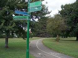 Cyclepath junction in Cator Park, Beckenham | |
| Length | 8 mi (13 km) |
| Location | Southern England, United Kingdom |
| Designation | UK National Trail |
| Trailheads | South Norwood Country Park and Cutty Sark ship, Greenwich |
| Use | Hiking, cycling |
| Hiking details | |
| Season | All year |
| Hazards | Section of road along Ladywell Road |

Waterlink Way is a long distance cyclepath and walking route in South East London. It extends from South Norwood Country Park (near Elmers End station) to the Cutty Sark ship in Greenwich, a total of eight miles.[1][2]
The Waterlink Way is an established part of the National Cycle Network (Route 21 between London and the Sussex coast).[3] It connects a number of parks and green spaces in South East London – including Ladywell Fields and Brookmill Park – while following the Pool and Ravensbourne rivers.[4] The route was designed to be accessible, with a large number of railway stations including Kent House, Lower Sydenham, Ladywell, Lewisham and Greenwich en route.[5]
In Cator Park, Beckenham the cyclepath links with the Capital Ring and Green Chain Walk long distance footpaths.
References
- ↑ "Lewisham Council - Waterlink Way". Lewisham.gov.uk. 2011-07-11. Retrieved 2013-07-11.
- ↑ "The Waterlink Way cycle route | Cycle routes | London Borough of Bromley". Bromley.gov.uk. 2011-03-24. Retrieved 2013-07-11.
- ↑ Wood, Donna, ed. (2009). Cycling in the UK (2011 ed.). AA Publishing. pp. 73–77. ISBN 9780749571566.
- ↑ "Waterlink Way – car-free cycling heaven!". The Sydenham Society. Retrieved 2013-07-11.
- ↑ "Waterlink Way - Map". Sustrans. 2013-04-08. Retrieved 2013-07-11.