Greenway footpath, London

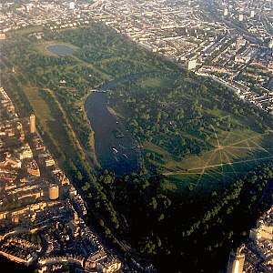
The Greenway is a footpath and cycleway in east London (mainly the London Borough of Newham) constructed on the embankment containing the Northern Outfall Sewer. It is similar to the Ridgeway in South London that covers the Southern Outfall Sewer.[1][2][3][4]
The western end of the Greenway is at Wick Lane in Old Ford (Bow) but the Greenway actually continues a bit further north to Victoria Park, London alongside Wick Lane underpass on pavement under the East Cross Route in London Borough of Tower Hamlets and it crosses Stratford, West Ham and Plaistow. The eastern end is at Royal Docks Road in Beckton. It was known locally as Sewerbank before a full renovation in the mid-nineties. Work has taken place to resurface and renovate the route - especially around the Olympic Park.
The Capital Ring Walk (section 14) follows the Greenway for most of its distance.
The western half of the Greenway embankment is roughly at house eaves height giving a view over the surrounding flat area. Between Stratford High Street and Beckton the route is flat. There is a renewed tarmac surface along its full length, with grass kept short on either side and bushes/trees on the embankment sides. The tarmac area is the width of a narrow two way road allowing easy passing of pedestrians and cyclists, with approx the same width of grass on either side. The renovation of the Greenway with gates, ramps, stairs and signs is almost complete by end of 2017, after major water supply work by Thames Water along the western half.
In mid-2018, Transport for London designated the section of the Greenway between the A13 and A118 as Quietway 22.
Start and end points
- 51°32′15″N 0°01′29″W / 51.53750°N 0.02472°W The route's western start point
- 51°31′08″N 0°04′21″E / 51.51889°N 0.07250°E The route's eastern end point
Gallery
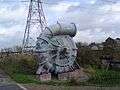 Spiral pipe sculpture
 Graffiti on the Greenway
See also
References
- ↑ Young, Nick (February 2017). "Weekend Walks: The Greenway (Beckton To Hackney)". Londonist. Retrieved 24 July 2017.
- ↑ Shepheard, Paul. "East London's Greenway by Adams & Sutherland Architects". BDOnline. Retrieved 28 March 2016.
- ↑ Thames Water (May 2, 2014). "The Greenway: Stratford to Beckton Walking Guide". Ifootpath.com. Retrieved 2017-07-24.
- ↑ "Jubilee Greenway - Transport for London". Tfl.gov.uk. Retrieved 2017-07-24.
External links
- The Northern Outfall Sewer east of Stratford
- Olympic walkway comp won by Adams and Sutherland
- The Road to 2012
- View Tube
- Route plot (.kml)
- https://www.newham.gov.uk/Pages/ServiceChild/Cycling-routes-consultation.aspx
Coordinates: 51°31′19″N 0°02′58″E / 51.52194°N 0.04944°E