Koliri
| Koliri Κολίρι | |
|---|---|
 | |
 Koliri | |
| Coordinates: 37°41′15″N 21°28′25″E / 37.6874°N 21.4737°ECoordinates: 37°41′15″N 21°28′25″E / 37.6874°N 21.4737°E | |
| Country | Greece |
| Administrative region | West Greece |
| Regional unit | Elis |
| Municipality | Pyrgos |
| Municipal unit | Pyrgos |
| Community[1] | |
| • Population | 979 (2011) |
| Time zone | UTC+2 (EET) |
| • Summer (DST) | UTC+3 (EEST) |
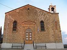
Saint Nicolas Church

Small pine trees appeared after the fires of August 2007
Koliri, (Greek: Κολίρι) is a village and a community in the municipality of Pyrgos, Elis, Greece. It is situated on a hillside, 3 km northeast of Pyrgos town centre and 3 km northwest of Varvasaina. The Greek National Road 74 (Tripoli – Olympia – Pyrgos) passes south of the village. Its population, according to the 2011 census, is 621 for the village, and 979 for the community, which includes the village Kolireikes Parangges. It has two churches: the Church of Saint Nicholas and the Church of the Saints Theodore. Its elevation is 90 m. Koliri suffered damage from the fires of August 2007. Koliri has a football team called Anatoli (meaning Sunrise in Greek), which plays in the local championships.
Population
| Year | Village | Community |
|---|---|---|
| 1981 | – | 1,012 |
| 1991 | 815 | – |
| 2001 | 708 | 1,061 |
| 2011 | 621 | 979 |
Gallery
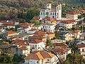 the center of the village along with Saint Theodoroi main church
 The centre
 Interior of Saint Nicholas Church.
 The forest after the fire
 Small pine trees appeared after the fires of August 2007
 The forest after the fires
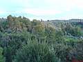 The forest before the fires
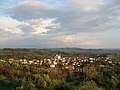 Overview of the village
 The area of the village next to Saint Nicholas Church
See also
References
- ↑ "Απογραφή Πληθυσμού - Κατοικιών 2011. ΜΟΝΙΜΟΣ Πληθυσμός" (in Greek). Hellenic Statistical Authority.
External links
This article is issued from
Wikipedia.
The text is licensed under Creative Commons - Attribution - Sharealike.
Additional terms may apply for the media files.