Xiromero
| Xiromero municipality Δήμος Ξηρομέρου | |
|---|---|
 Xiromero municipality | |
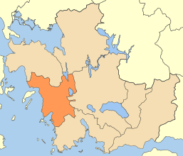
 Xiromero municipality Location within the region 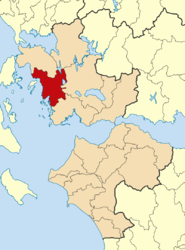 | |
| Coordinates: 38°32′N 21°5′E / 38.533°N 21.083°ECoordinates: 38°32′N 21°5′E / 38.533°N 21.083°E | |
| Country | Greece |
| Administrative region | West Greece |
| Regional unit | Aetolia-Acarnania |
| Area | |
| • Municipality | 590.1 km2 (227.8 sq mi) |
| Population (2011)[1] | |
| • Municipality | 11,737 |
| • Municipality density | 20/km2 (52/sq mi) |
| Time zone | UTC+2 (EET) |
| • Summer (DST) | UTC+3 (EEST) |
Xiromero municipality (Greek: Δήμος Ξηρομέρου) is a municipality in the Aetolia-Acarnania regional unit, West Greece region, Greece. The seat of the municipality is the town Astakos.[2] Its borders do not coincide with the historical region of Xiromero, which extends to parts of the territory of the neighbouring municipality of Aktio-Vonitsa and most notably the area around Katouna. The municipality has an area of 590.113 km2.[3]
Municipality
The municipality Xiromero was formed at the 2011 local government reform by the merger of the following 3 former municipalities, that became municipal units:[2]
References
- ↑ "Απογραφή Πληθυσμού - Κατοικιών 2011. ΜΟΝΙΜΟΣ Πληθυσμός" (in Greek). Hellenic Statistical Authority.
- 1 2 Kallikratis law Greece Ministry of Interior (in Greek)
- ↑ "Population & housing census 2001 (incl. area and average elevation)" (PDF) (in Greek). National Statistical Service of Greece.
| Regional unit of Achaea | 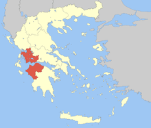 | |
|---|---|---|
| Regional unit of Aetolia-Acarnania | ||
| Regional unit of Elis | ||
| ||
This article is issued from
Wikipedia.
The text is licensed under Creative Commons - Attribution - Sharealike.
Additional terms may apply for the media files.