São Nicolau Airport
| São Nicolau Airport | |||||||||||
|---|---|---|---|---|---|---|---|---|---|---|---|
 | |||||||||||
| Summary | |||||||||||
| Airport type | Public | ||||||||||
| Operator | Aeroportos e Segurança Aérea (ASA) | ||||||||||
| Serves | Ribeira Brava | ||||||||||
| Location | São Nicolau, Cape Verde | ||||||||||
| Elevation AMSL | 180 m / 591 ft | ||||||||||
| Coordinates | 16°35′16″N 24°17′02″W / 16.58778°N 24.28389°WCoordinates: 16°35′16″N 24°17′02″W / 16.58778°N 24.28389°W | ||||||||||
| Map | |||||||||||
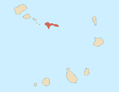
 SNE Location in Cape Verde | |||||||||||
| Runways | |||||||||||
| |||||||||||
| Statistics (2017[1]) | |||||||||||
| |||||||||||
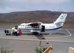
São Nicolau Airport (Portuguese: Aeródromo de São Nicolau) (IATA: SNE, ICAO: GVSN) is the domestic airport of the island of São Nicolau, Cape Verde. It is located 3 km north of the village Preguiça and about 3 km south of the island capital Ribeira Brava. Its runway is 1,400 meters and is categorized 3C.[2]
Airlines and destinations
| Airlines | Destinations |
|---|---|
| Binter CV | Praia |
| Cabo Verde Express | Sal, São Vicente |
Statistics
| Year | Passengers | Operations | Cargo (t) |
|---|---|---|---|
| 2012[3] | 26,436 | - | - |
| 2013[4] | 24,732 | 618 | 31 |
| 2016[1] | 26,476 | 604 | 24 |
| 2017[1] | 27,038 | 574 | 14 |
See also
References
- 1 2 3 "Boletim Estatístico de Tráfego – Ano 2017" (PDF) (in Portuguese). ASA. January 2018. Retrieved 11 September 2018.
- ↑ Aeródromo de São Nicolau, Aeroportos e Segurança Aérea (in Portuguese)
- ↑ "Statistics in Airports" (PDF) (in Portuguese). ASA. 1 October 2013. Retrieved 17 September 2014.
- ↑ "Relative Statistics in Airports" (PDF) (in Portuguese). ASA. 1 April 2014. Retrieved 17 September 2014.
External links

- Airport information for GVSN at World Aero Data. Data current as of October 2006.
The island of São Nicolau | ||||||
|---|---|---|---|---|---|---|
| Ribeira Brava |
|  | ||||
| Tarrafal de São Nicolau |
| |||||
| Mountains | ||||||
| Other topics | ||||||
This article is issued from
Wikipedia.
The text is licensed under Creative Commons - Attribution - Sharealike.
Additional terms may apply for the media files.