Prášily
| Prášily | ||
|---|---|---|
| Municipality | ||
 | ||
| ||
 Prášily | ||
| Coordinates: 49°6′18″N 13°23′21″E / 49.10500°N 13.38917°ECoordinates: 49°6′18″N 13°23′21″E / 49.10500°N 13.38917°E | ||
| Country |
| |
| Region | Plzeň | |
| District | Klatovy | |
| Area | ||
| • Total | 112.27 km2 (43.35 sq mi) | |
| Elevation | 880 m (2,890 ft) | |
| Population (1.1.2015) | ||
| • Total | 152 | |
| • Density | 1.4/km2 (3.5/sq mi) | |
| Postal code | 341 43 to 342 01 | |

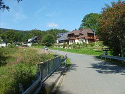
Prášily is a village and municipality (obec) in Klatovy District in the Plzeň Region of the Czech Republic.
The municipality covers an area of 112.27 square kilometres (43.35 sq mi), and has a population of 153 (as at 3 July 2006).
Prášily lies approximately 34 kilometres (21 mi) south of Klatovy, 72 km (45 mi) south of Plzeň, and 132 km (82 mi) south-west of Prague.
Gallery
.JPG) Sweetshop "Pampeliška" (Translated:Dandelion)
Sweetshop "Pampeliška" (Translated:Dandelion).JPG) "Hostinec u Michala" (Michaels restaurant)
"Hostinec u Michala" (Michaels restaurant).JPG) Pension "Brücknerův dům" (Brükner House)
Pension "Brücknerův dům" (Brükner House).JPG) Indian village (child's toys)
Indian village (child's toys).JPG) Memorial of villages destroyed by Czechoslovak army on 50th years of 20th century
Memorial of villages destroyed by Czechoslovak army on 50th years of 20th century.JPG) Classic Czech Timbering house
Classic Czech Timbering house
References
| Wikimedia Commons has media related to Prášily. |
This article is issued from
Wikipedia.
The text is licensed under Creative Commons - Attribution - Sharealike.
Additional terms may apply for the media files.