Číhaň
| Číhaň | |||
|---|---|---|---|
| Municipality | |||
 | |||
| |||
 Číhaň | |||
| Coordinates: 49°20′28″N 13°25′43″E / 49.34111°N 13.42861°ECoordinates: 49°20′28″N 13°25′43″E / 49.34111°N 13.42861°E | |||
| Country |
| ||
| Region | Plzeň | ||
| District | Klatovy | ||
| Area | |||
| • Total | 8.51 km2 (3.29 sq mi) | ||
| Elevation | 593 m (1,946 ft) | ||
| Population (1.1.2014) | |||
| • Total | 197 | ||
| • Density | 23/km2 (60/sq mi) | ||
| Postal code | 341 42 | ||

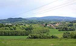
Číhaň is a village and municipality (obec) in Klatovy District in the Plzeň Region of the Czech Republic.
The municipality covers an area of 8.51 square kilometres (3.29 sq mi), and has a population of 192 (as at 3 July 2006).
Číhaň lies approximately 13 kilometres (8 mi) south-east of Klatovy, 46 km (29 mi) south of Plzeň, and 110 km (68 mi) south-west of Prague.
References
| Wikimedia Commons has media related to Číhaň. |
This article is issued from
Wikipedia.
The text is licensed under Creative Commons - Attribution - Sharealike.
Additional terms may apply for the media files.