Klatovy
| Klatovy | |||
| Town | |||
 | |||
|
|||
| Country | Czech Republic | ||
|---|---|---|---|
| Region | Plzeň | ||
| District | Klatovy | ||
| Commune | Klatovy | ||
| Parts | 30
| ||
| River | Úhlava | ||
| Center | Náměstí Míru | ||
| - elevation | 405 m (1,329 ft) | ||
| - coordinates | 49°23′43″N 13°17′36.75″E / 49.39528°N 13.2935417°ECoordinates: 49°23′43″N 13°17′36.75″E / 49.39528°N 13.2935417°E | ||
| Area | 80.67 km2 (31.15 sq mi) | ||
| Population | 22,344 (2015-01-01) | ||
| Density | 277/km2 (717/sq mi) | ||
| Founded | 1260 | ||
| Mayor | Rudolf Salvetr | ||
| Timezone | CET (UTC+1) | ||
| - summer (DST) | CEST (UTC+2) | ||
| Postal code | 339 01 | ||
  Location in the Czech Republic | |||
| Wikimedia Commons: Klatovy | |||
| Statistics: statnisprava.cz | |||
| Website: www.klatovy.cz | |||
| Klatovy | |
| Municipality with Extended Competence | |
| Country | Czech Republic |
|---|---|
| Region | Plzeň |
| Parts | Klatovy, Nýrsko, Plánice |
| Area | 906.37 km2 (349.95 sq mi) |
| Population | 50,482 (2005-12-31) |
| Density | 56/km2 (145/sq mi) |
| Klatovy | |
| Municipality with Commissioned Local Authority | |
| Country | Czech Republic |
|---|---|
| Region | Plzeň |
| Little District | Klatovy |
| Municipalities | Běhařov, Běšiny, Bezděkov, Biřkov, Bolešiny, Čachrov, Černíkov, Červené Poříčí, Dlažov, Dolany, Chlistov, Chudenice, Janovice nad Úhlavou, Javor, Ježovy, Klatovy, Klenová, Křenice, Lomec, Měčín, Mezihoří, Mochtín, Myslovice, Obytce, Ostřetice, Poleň, Předslav, Strážov, Švihov, Týnec (Klatovy District), Vrhaveč, Vřeskovice |
| Area | 584.58 km2 (225.71 sq mi) |
| Population | 39,104 (2005-12-31) |
| Density | 67/km2 (174/sq mi) |
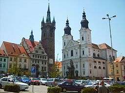
Klatovy (Czech pronunciation: [ˈklatovɪ]; German: Klattau) is a town in the Plzeň Region of the Czech Republic.
Klatovy is the seat of the Municipality with Extended Competence and Municipality with Commissioned Local Authority.
History
Klatovy was founded during 1260–1263 by Přemysl Otakar II. There are several historic buildings in the town such as the Black Tower, the Baroque Pharmacy, the Jesuit church with catacombs and the Archdeacon's church. The town's significant German population was expelled from their home in 1945.
Twin cities
Klatovy is twinned with the following cities:
Notable people
Klatovy was linked with many influential persons:
- Bohuslav Balbín - writer, historian, Jesuit
- August Breisky - medical professor and gynaecological researcher
- Johann Brotan - mechanical engineer and inventor of the Brotan boiler
- Josef Dobrovský - philologist, historian
- Václav Fišer - Olympic long jumper and triple jumper
- Petr Frydrych - javelin thrower
- Josef Hlávka - architect
- Franz Kiwisch von Rotterau - medical professor and gynaecological researcher
- Karel Klostermann - writer
- Václav Matěj Kramerius - publisher, journalist and writer
- František Křižík - inventor, electrical engineer and entrepreneur
- Lubor Niederle - Father of Czech archaeology
- František Palacký - historian and politician
- Jaroslav Vrchlický - lyrical poet
- Ivana Sekyrová - Olympic long-distance runner
Gallery
.jpg)
.jpg)
.jpg)
Sources
External links
| Wikimedia Commons has media related to Klatovy. |
- More information about the town of Klatovy available in English
- Klatovy District (in English)
- Art gallery Klatovy/Klenová castle (in English)
- Skydiving club at airport Klatovy (in English)
This article is issued from
Wikipedia.
The text is licensed under Creative Commons - Attribution - Sharealike.
Additional terms may apply for the media files.