Polynesian navigation
Traditional Polynesian navigation was used for thousands of years to make long voyages across thousands of miles of the open Pacific Ocean. Navigators travelled to small inhabited islands using wayfinding techniques and knowledge passed by oral tradition from master to apprentice, often in the form of song. Generally each island maintained a guild of navigators who had very high status; in times of famine or difficulty they could trade for aid or evacuate people to neighboring islands. As of 2014, these traditional navigation methods are still taught in the Polynesian outlier of Taumako Island in the Solomons.
Polynesian navigation used some navigational instruments, which predate and are distinct from the machined metal tools used by European navigators (such as the sextant, first produced in 1730; the sea astrolabe, from around late 15th century; and the marine chronometer, invented in 1761). However, they also relied heavily on close observation of sea sign and a large body of knowledge from oral tradition.[1]
Both wayfinding techniques and outrigger canoe construction methods have been kept as guild secrets, but in the modern revival of these skills, they are being recorded and published.
History
Between about 3000 and 1000 BC speakers of Austronesian languages spread through the islands of Southeast Asia – almost certainly starting out from Taiwan,[2] as tribes whose natives were thought to have previously arrived from mainland South China about 8000 years ago – into the edges of western Micronesia and on into Melanesia. In the archaeological record there are well-defined traces of this expansion which allow the path it took to be followed and dated with a degree of certainty. In the mid-2nd millennium BC a distinctive culture appeared suddenly in north-west Melanesia, in the Bismarck Archipelago, the chain of islands forming a great arch from New Britain to the Admiralty Islands. This culture, known as Lapita, stands out in the Melanesian archeological record, with its large permanent villages on beach terraces along the coasts. Particularly characteristic of the Lapita culture is the making of pottery, including a great many vessels of varied shapes, some distinguished by fine patterns and motifs pressed into the clay. Within a mere three or four centuries between about 1300 and 900 BC, the Lapita culture spread 6000 km further to the east from the Bismarck Archipelago, until it reached as far as Tonga and Samoa.[3] Lapita pottery persisted in places such as Samoa, Tonga, and Fiji for many years after its upbringing to Western and Central Polynesia. However, pottery-making died out in most of Polynesia due to the scarcity of clay on the islands.[4] In this region, the distinctive Polynesian culture developed. The Polynesians are then believed to have spread eastward from the Samoan Islands into the Marquesas, the Society Islands, the Hawaiian Islands and Easter Island; and south to New Zealand. The pattern of settlement also extended to the north of Samoa to the Tuvaluan atolls, with Tuvalu providing a stepping stone to migration into the Polynesian Outlier communities in Melanesia and Micronesia.[5][6][7]
Canoes and navigation
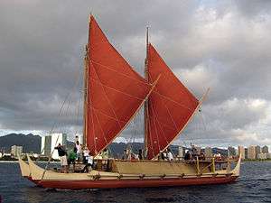
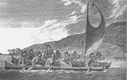
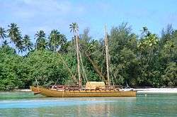
The Polynesians encountered nearly every island within the vast Polynesian Triangle using outrigger canoes or double-hulled canoes. The double-hulled canoes were two large hulls, equal in length, and lashed side by side. The space between the paralleled canoes allowed for storage of food, hunting materials, and nets when embarking on long voyages.[8] Polynesians used strategic and natural navigation aides such as the stars, ocean currents, and wind patterns.[9]
Navigational devices
There are numerous traditional Polynesian devices used for navigating and/or teaching navigation. These include charts, spatial representations of islands and the conditions around them, and navigational instruments, such as those for measuring the elevation of celestial objects. They also include non-physical devices such as songs and stories for memorizing the properties of stars, islands, and navigational routes.
Navigational techniques
Navigation relies heavily on constant observation and memorization; you must constantly be aware of your surroundings. You cannot simply look up at the stars and know where you are. You are only able to know where you are if you are able to memorize where you have sailed from. The sun was the main guide for voyagers because they could follow its exact points as it rose and set; then, at night time they'd switch to using the stars rising and setting points. With constant observation, comes the knowledge of knowing and remembering the speed of your canoe (when it speeds up and slows down), what direction you are facing, and what time of the day or night it is. In the ancient days, they did not have watches, compasses or speedometers but they had their minds and the ability to memorize their surroundings. When there are no stars because of a cloudy night or during midday, the navigator would use the winds and swells to guide them.[10] Polynesian navigators employed a whole range of techniques including use of the stars, the movement of ocean currents and wave patterns, the air and sea interference patterns caused by islands and atolls, the flight of birds, the winds and the weather.[11]
Bird observation
Certain seabirds such as the White tern and Noddy tern feed on fish in the morning and return to rest on land at night time. Navigators use these birds to guide them to land by following where the birds are flying from in the morning and flying toward at night. Birds habits change during nesting season which is another thing navigators must be mindful of when voyaging. Generally speaking, if a navigator can see a large group of birds, that is a much more reliable sign for land than following one, two or a small group of birds.[12] Harold Gatty suggested that long-distance Polynesian voyaging followed the seasonal paths of bird migrations. In "The Raft Book",[13] a survival guide he wrote for the U.S. military during World War II, Gatty outlined various Polynesian navigation techniques Allied sailors or aviators wrecked at sea could use to find their way to land. There are some references in their oral traditions to the flight of birds and some say that there were range marks onshore pointing to distant islands in line with the West Pacific Flyway. A voyage from Tahiti, the Tuamotus or the Cook Islands to New Zealand might have followed the migration of the long-tailed cuckoo (Eudynamys taitensis) just as the voyage from Tahiti to Hawaiʻi would coincide with the track of the Pacific golden plover (Pluvialis fulva) and the bristle-thighed curlew (Numenius tahitiensis). It is also believed that Polynesians employed shore-sighting birds as did many seafaring peoples. One theory is that they would have taken a frigatebird (Fregata) with them. These birds refuse to land on the water as their feathers will become waterlogged making it impossible to fly. When the voyagers thought they were close to land they may have released the bird, which would either fly towards land or else return to the canoe.[11]
Navigation by the stars
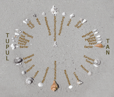
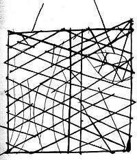
The positions of the stars helped guide Polynesians through their voyaging routes. Stars- as opposed to planets are able to hold a steady position year-round. The only thing that changes is the time the star rises which changes seasonally. Polynesian voyagers would follow stars near the horizon whether they were just rising or about to set and they used these specific stars for guidance. These stars were used to set the direction for their canoe up until the point when those stars rise too high and are no longer easy to follow. Once the star they've used to guide them rises too high, they use the next star that rises from the previous stars exact rising point to guide them next. The canoes latitude and the course being followed determines how many stars the navigator will need to get him to his destination.[12] For navigators near the equator celestial navigation is simplified since the whole celestial sphere is exposed. Any star that passes the zenith (overhead) is on the celestial equator, the basis of the equatorial coordinate system. Each star has a specific declination, and when they rise or set, they give a bearing for navigation. Stars are learned by compass point, making a star compass (star compasses list ~150 stars, in some systems[15]). A simplified compass might list only a couple of dozen stars.[16] For example, in the Caroline Islands Mau Piailug taught natural navigation using a star compass diagrammed here. The development of "sidereal compasses" has been studied[17] and theorized to have developed from an ancient pelorus.[11]
The Polynesians also took measurements of stellar elevation to determine their latitude. The latitudes of specific islands were also known, and the technique of "sailing down the latitude" was used.
Swell
The Polynesians also use wave and swell formations to navigate. Many of the habitable areas of the Pacific Ocean are groups of islands (or atolls) in chains hundreds of kilometers long. Island chains have predictable effects on waves and on currents. Navigators who lived within a group of islands would learn the effect various islands had on their shape, direction, and motion and would have been able to correct their path in accordance with the changes they perceived. When they arrived in the vicinity of a chain of islands they were unfamiliar with, they may have been able to transfer their experience and deduce that they were nearing a group of islands. Once they had arrived fairly close to a destination island, they would have been able to pinpoint its location by sightings of land-based birds, certain cloud formations, as well as the reflections shallow water made on the undersides of clouds. It is thought that the Polynesian navigators may have measured the time it took to sail between islands in "canoe-days" or a similar type of expression.[11] The energy that is transferred from the wind to the sea are wind waves. The waves that are created when the energy travels down away from the source area (like ripples) are known as swell. When the winds are strong at the source area, the swell is larger. The longer the wind blows, the longer the swell lasts. Because the swells of the ocean can remain consistent for days, navigators relied on them to carry their canoe in a straight line from one house on the star compass to a house of the same name on the opposite side of the horizon. Navigators were not always able to see stars; because of this, they relied on the swells of the ocean. Swell patterns are a much more reliable method of navigation than the actual waves which are determined by the local winds. Swells move in a straight direction which makes it easier for the navigator to determine whether the canoe is heading in the correct direction.[18]
Routes

On his first voyage of Pacific exploration, Captain James Cook had the services of a Polynesian navigator, Tupaia, who drew a chart of the islands within a 2,000 miles (3,200 km) radius (to the north and west) of his home island of Ra'iatea. Tupaia had knowledge of 130 islands and named 74 on his chart.[19] Tupaia had navigated from Ra'iatea in short voyages to 13 islands. He had not visited western Polynesia, as since his grandfather's time the extent of voyaging by Raiateans had diminished to the islands of eastern Polynesia. His grandfather and father had passed to Tupaia the knowledge as to the location of the major islands of western Polynesia and the navigation information necessary to voyage to Fiji, Samoa and Tonga.[20] Tupaia was hired by Joseph Banks, the ship's naturalist, who wrote that Cook ignored Tupaia's chart and his skills as a navigator.[21]
Subantarctic and Antarctica
There is academic debate on the furthest southern extent of Polynesian expansion.
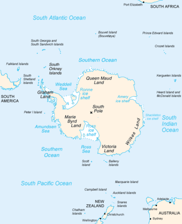
There is material evidence of Polynesian visits to some of the subantarctic islands to the south of New Zealand, which are outside Polynesia proper. Remains of a Polynesian settlement dating back to the 13th century were found on Enderby Island in the Auckland Islands.[22][23][24][25] Descriptions of a shard of early Polynesian pottery buried on the Antipodes Islands[26] are unsubstantiated, and the Museum of New Zealand Te Papa Tongarewa, where it was supposedly stored, has stated that "The Museum has not been able to locate such a shard in its collection, and the original reference[27] to the object in the Museum's collection documentation indicates no reference to Polynesian influences."
Oral history describes Ui-te-Rangiora, around the year 650, leading a fleet of Waka Tīwai south until they reached, "a place of bitter cold where rock-like structures rose from a solid sea".[28] The brief description might match the Ross Ice Shelf or possibly the Antarctic mainland,[29] but may be a description of icebergs surrounded by sea Ice found in the Southern Ocean.[30][31] The account also describes snow.
Pre-Columbian contact with the Americas
In the mid-20th century, Thor Heyerdahl proposed a new theory of Polynesian origins (one which did not win general acceptance), arguing that the Polynesians had migrated from South America on balsa-log boats.[32][33]
The presence in the Cook Islands of sweet potato that is a plant native to the Americas (called kūmara in Māori), which have been radiocarbon-dated to 1000 CE, has been cited as evidence that Americans could have traveled to Oceania. The current thinking is that sweet potato was brought to central Polynesia circa 700 CE and spread across Polynesia from there, possibly by Polynesians who had traveled to South America and back.[34] An alternative explanation posits biological dispersal; plants and/or seeds could float across the Pacific without any human contact.[35]
A 2007 study published in the Proceedings of the National Academy of Sciences examined chicken bones at El Arenal near the Arauco Peninsula, Arauco Province, Chile. The results suggested Oceania-to-America contact. Chickens originated in southern Asia and the Araucana breed of Chile was thought to have been brought by Spaniards around 1500. However, the bones found in Chile were radiocarbon-dated to between 1304 and 1424, well before the documented arrival of the Spanish. DNA sequences taken were exact matches to those of chickens from the same period in American Samoa and Tonga, both over 5000 miles (8000 kilometers) away from Chile. The genetic sequences were also similar to those found in Hawaiʻi and Easter Island, the closest island at only 2500 miles (4000 kilometers), and unlike any breed of European chicken.[36][37][38] Although this initial report suggested a Polynesian pre-Columbian origin a later report looking at the same specimens concluded:
A published, apparently pre-Columbian, Chilean specimen and six pre-European Polynesian specimens also cluster with the same European/Indian subcontinental/Southeast Asian sequences, providing no support for a Polynesian introduction of chickens to South America. In contrast, sequences from two archaeological sites on Easter Island group with an uncommon haplogroup from Indonesia, Japan, and China and may represent a genetic signature of an early Polynesian dispersal. Modeling of the potential marine carbon contribution to the Chilean archaeological specimen casts further doubt on claims for pre-Columbian chickens, and definitive proof will require further analyses of ancient DNA sequences and radiocarbon and stable isotope data from archaeological excavations within both Chile and Polynesia.[39]
In the last 20 years, the dates and anatomical features of human remains found in Mexico and South America have led some archaeologists to propose that those regions were first populated by people who crossed the Pacific several millennia before the Ice Age migrations; according to this theory, these would have been either eliminated or absorbed by the Siberian immigrants. However, current archaeological evidence for human migration to and settlement of remote Oceania (i.e., the Pacific Ocean eastwards of the Solomon Islands) is dated to no earlier than approximately 3,500 BP;[40] trans-Pacific contact with the Americas coinciding with or pre-dating the Beringia migrations of at least 11,500 BP is highly problematic, except for movement along intercoastal routes.
Recently, linguist Kathryn A. Klar of University of California, Berkeley and archaeologist Terry L. Jones of California Polytechnic State University have proposed contacts between Polynesians and the Chumash and Gabrielino of Southern California, between 500 and 700. Their primary evidence consists of the advanced sewn-plank canoe design, which is used throughout the Polynesian Islands, but is unknown in North America – except for those two tribes. Moreover, the Chumash word for "sewn-plank canoe", tomolo'o, may have been derived from kumulaa'au, a Hawaiian word meaning "useful tree".
In 2008, an expedition starting on the Philippines sailed two modern Wharram-designed catamarans loosely based on a Polynesian catamaran found in Auckland Museum New Zealand. The boats were built in the Philippines by an experienced boat builder to Wharram designs using modern strip plank with epoxy resin glue built over plywood frames. The catamarans had modern Dacron sails, Terylene stays and sheets with modern roller blocks. Wharram says he used Polynesian navigation to sail along the coast of Northern New Guinea and then sailed 150 miles to an island for which he had modern charts, proving that it is possible to sail a modern catamaran along the path of the Lapita Pacific migration.[41] Unlike many other modern Polynesian "replica" voyages the Wharram catamarans were not towed or escorted by a modern vessel with modern GPS navigation system, nor were they fitted with a motor.
Polynesian contact with the prehispanic Mapuche culture in central-south Chile has been suggested because of apparently similar cultural traits, including words like toki (stone axes and adzes), hand clubs similar to the Māori wahaika, the sewn-plank canoe as used on Chiloe island, the curanto earth oven (Polynesian umu) common in southern Chile, fishing techniques such as stone wall enclosures, a hockey-like game, and other potential parallels. Some strong westerlies and El Niño wind blow directly from central-east Polynesia to the Mapuche region, between Concepcion and Chiloe. A direct connection from New Zealand is possible, sailing with the Roaring Forties. In 1834, some escapees from Tasmania arrived at Chiloe Island after sailing for 43 days.[42][43]
Revival
The first settlers who sailed to the Hawaiian Islands are said to have arrived as early as 400 C.E by Polynesians from the Marquesas Islands. Captain James Cook was the first European to arrive to the island of Kaua’i in 1778. He returned a year later and was killed in an altercation with natives at Kealakekua Bay. In 1973, Ben Finney established the Polynesian Voyaging Society to test the contentious question of how Polynesians found their islands. The team claimed to be able to replicate ancient Hawaiian double-hulled canoes capable of sailing across the ocean using strictly traditional voyaging techniques.[44] In 1980, a Hawaiian named Nainoa Thompson invented a new method of non-instrument navigation (called the "modern Hawaiian wayfinding system"), enabling him to complete the voyage from Hawaiʻi to Tahiti and back. In 1987, a Māori named Matahi Whakataka (Greg Brightwell) and his mentor Francis Cowan sailed from Tahiti to Aotearoa without instruments.
In New Zealand, a leading Māori navigator and ship builder is Hector Busby who was also inspired and influenced by Nainoa Thompson and Hokulea's voyage there in 1985.[45][46]
Post-colonial research history
Knowledge of the traditional Polynesian methods of navigation was widely lost after contact with and colonization by Europeans. This caused debates over the reasons for the presence of the Polynesians in such isolated and scattered parts of the Pacific. According to Andrew Sharp, the explorer Captain James Cook, already familiar with Charles de Brosses's accounts of large groups of Pacific islanders who were driven off course in storms and ended up hundreds of miles away with no idea where they were, encountered in the course of one of his own voyages a castaway group of Tahitians who had become lost at sea in a gale and blown 1000 miles away to the island of Atiu. Cook wrote that this incident "will serve to explain, better than the thousand conjectures of speculative reasoners, how the detached parts of the earth, and, in particular, how the South Seas, may have been peopled".[47]
By the late 19th century to the early 20th century, a more generous view of Polynesian navigation had come into favor, creating a much romanticized view of their seamanship, canoes, and navigational expertise. Late 19th and early 20th centuries writers such as Abraham Fornander and Percy Smith told of heroic Polynesians migrating in great coordinated fleets from Asia far and wide into present-day Polynesia.[33]
Another view was presented by Andrew Sharp who challenged the "heroic vision" hypothesis, asserting instead that Polynesian maritime expertise was severely limited in the field of exploration and that as a result the settlement of Polynesia had been the result of luck, random island sightings, and drifting, rather than as organized voyages of colonization. Thereafter the oral knowledge passed down for generations allowed for eventual mastery of traveling between known locations.[48] Sharp's reassessment caused a huge amount of controversy and led to a stalemate between the romantic and the skeptical views.[33]
By the mid-to-late 1960s it was time for a new hands-on approach. Anthropologist David Lewis sailed his catamaran from Tahiti to New Zealand using stellar navigation without instruments.[49] Anthropologist and historian Ben Finney built Nalehia, a 40-foot (12 m) replica of a Hawaiian double canoe. Finney tested the canoe in a series of sailing and paddling experiments in Hawaiian waters. At the same time, ethnographic research in the Caroline Islands in Micronesia brought to light the fact that traditional stellar navigational methods were still very much in everyday use there. The building and testing of proa canoes (wa) inspired by traditional designs, the harnessing of knowledge from skilled Micronesians, as well as voyages using stellar navigation, allowed practical conclusions about the seaworthiness and handling capabilities of traditional Polynesian canoes and allowed a better understanding of the navigational methods that were likely to have been used by the Polynesians and of how they, as people, were adapted to seafaring.[50] Recent re-creations of Polynesian voyaging have used methods based largely on Micronesian methods and the teachings of a Micronesian navigator, Mau Piailug.[51]
In accordance with Polynesian oral tradition, the geography of Polynesian navigation pathways are said to resemble the geometric qualities of an octopus with head centred on Ra'iātea (French Polynesia) and tentacles spread out across the Pacific.[52] In oral tradition the octopus is known by various names such as Taumata-Fe'e-Fa'atupu-Hau (Grand Octopus of Prosperity), Tumu-Ra'i-Fenua (Beginning-of-Heaven-and-Earth) and Te Wheke-a-Muturangi (The Octopus of Muturangi).
Notes
- ↑ Clark, Liesl (15 February 2000). "Polynesia's Genius Navigators". Retrieved 17 November 2016.
- ↑ Howe, K. R (2006), Vaka Moana: Voyages of the Ancestors – the discovery and settlement of the Pacific, Albany, Auckland: David Bateman, pp. 92–98
- ↑ Bellwood 1987, pp. 45–65.
- ↑ "Lapita culture: ancestors of Polynesians, Micronesians, and some coastal areas of Melanesia". Originalpeople.org. Retrieved April 11, 2018.
- ↑ Bellwood 1987, pp. 29, 54.
- ↑ Bayard, D. T. (1976). The Cultural Relationships of the Polynesian Outiers. Otago University, Studies in Prehistoric Anthropology, Vol. 9.
- ↑ Kirch, P. V. (1984). "The Polynesian Outliers: Continuity, change, and replacement". Journal of Pacific History. 19 (4): 224–238. doi:10.1080/00223348408572496.
- ↑ Bellwood, Peter (1978). The Polynesians Prehistory of an Island People. NY: Thames and Hudson. p. 39. ISBN 9780500020937.
- ↑ Bellwood, Peter (1978). The Polynesians Prehistory of an Island People. NY: Thames and Hudson. p. 42. ISBN 9780500020937.
- ↑ Thompson, Nainoa. "On Wayfinding". Polynesian Voyaging Society. Retrieved April 11, 2018.
- 1 2 3 4 Gatty 1958.
- 1 2 Lewis, David (1972). We, the Navigators. HI: University of Hawaii Press. ISBN 9780824802295.
- ↑ "Be Your Own Navigator," Smithsonian Libraries Unbound, 11 February 2016.
- ↑ "Star Compasses". Polynesian Voyaging Society. Archived from the original on 5 August 2010.
- ↑ Harold Gatty (1958). Nature Is Your Guide, p. 45
- ↑ Star Compass diagrams with translations
- ↑ Halpern, M. D. (1985) The Origins of the Carolinian Sidereal Compass, Master's thesis, Texas A & M University
- ↑ Gooley, Tristan (2016). How to Read Water: Clues, Signs & Patterns from Puddles to the Sea. NY: Hodder & Stoughton. ISBN 9781473615205.
- ↑ Druett, Joan (1987). Tupaia – The Remarkable Story of Captain Cook's Polynesian Navigator. New Zealand: Random House. pp. 226–227.
- ↑ Druett, Joan (1987). Tupaia – The Remarkable Story of Captain Cook's Polynesian Navigator. New Zealand: Random House. pp. 218–233.
- ↑ O'Sullivan, Dan (2008). In search of Captain Cook. I.B. Taurus. p. 148. ISBN 9781845114831.
- ↑ O'Connor, Tom Polynesians in the Southern Ocean: Occupation of the Auckland Islands in Prehistory in New Zealand Geographic 69 (September–October 2004): 6–8
- ↑ Anderson, Atholl J., & Gerard R. O'Regan "To the Final Shore: Prehistoric Colonisation of the Subantarctic Islands in South Polynesia" in Australian Archaeologist: Collected Papers in Honour of Jim Allen Canberra: Australian National University, 2000. 440–454.
- ↑ Anderson, Atholl J., & Gerard R. O'Regan The Polynesian Archaeology of the Subantarctic Islands: An Initial Report on Enderby Island Southern Margins Project Report. Dunedin: Ngai Tahu Development Report, 1999
- ↑ Anderson, Atholl J. (2005). "Subpolar Settlement in South Polynesia". Antiquity. 79 (306): 791–800. doi:10.1017/S0003598X00114930.
- ↑ "Nga-Iwi-o-Aotea". Te Ao Hou (59): 43. 1967.
- ↑ "Captain Fairchild to the Secretary, Marine Department, Wellington". Appendix to the Journals of the House of Representatives, 1886 Session I, H-24 Page 6.
- ↑ "Expedition Cruises Fathom Expeditions Custom Cruise". Archived from the original on 23 June 2010. Retrieved 2 March 2016.
- ↑ "All About Antarctica". Retrieved 2 March 2016.
- ↑ "The Left Coaster: freeze frame". Retrieved 2 March 2016.
- ↑ "Ui-te-Rangiora". Encyclopædia Britannica. Retrieved 2 March 2016.
- ↑ Sharp 1963, pp. 122–128.
- 1 2 3 Finney 1963, p. 5.
- ↑ Van Tilburg, Jo Anne (1994). Easter Island: Archaeology, Ecology and Culture. Washington, DC: Smithsonian Institution Press.
- ↑ Montenegro, A.; et al. "Modeling the prehistoric arrival of the sweet potato in Polynesia" (PDF). Journal of Archaeological Science. University of Victoria. Archived from the original (PDF) on 28 June 2011. Retrieved 6 September 2011.
- ↑ Whipps, Heather (4 June 2007), "Chicken Bones Suggest Polynesians Found Americas Before Columbus", Live Science, retrieved 5 June 2007.
- ↑ Maugh, Thomas H., II (5 June 2007). "Polynesians beat Spaniards to South America, study shows". Los Angeles Times.
- ↑ Storey, A. A.; et al. (2007). "Radiocarbon and DNA evidence for a pre-Columbian introduction of Polynesian chickens to Chile". Proceedings of the National Academy of Sciences. 104 (25): 10335–10339. doi:10.1073/pnas.0703993104. PMC 1965514.
- ↑ Gongora, J.; et al. (2008). "Indo-European and Asian origins for Chilean and Pacific chickens revealed by mtDNA". Proceedings of the National Academy of Sciences. 105 (30): 10308–10313. doi:10.1073/pnas.0801991105. PMC 2492461.
- ↑ Kirch, Patrick V. Background to Pacific Archaeology and Prehistory Archived 9 June 2007 at the Wayback Machine., Oceanic Archaeology Laboratory, Univ. California, Berkeley.
- ↑ Hympendahl, Klaus. "Lapita Voyage – The first expedition following the migration route of the ancient Polynesians". Archived from the original on 3 March 2016. Retrieved 2 March 2016.
- ↑ "Rapa Nui" (in Spanish). Retrieved 5 June 2007.
- ↑ Lewis, David (1972). We, the Navigators: The Ancient Art of Landfinding in the Pacific. Canberra: Australian National University Press.
- ↑ Finney, Ben. "Voyaging into Polynesia's Past The Founding of the Polynesian Voyaging Society". Hokule'a. Retrieved April 11, 2018.
- ↑ "Profile: Hekenukumai (Hector) Busby". Toi Māori Aotearoa. Archived from the original on 11 October 2014. Retrieved 12 October 2014.
- ↑ "Waka Tapu Canoes". NZMACI & Taitokerau Tarai Waka. Retrieved 12 October 2014.
- ↑ Sharp 1963, p. 16.
- ↑ Sharp 1963.
- ↑ Lewis 1976.
- ↑ Finney 1963, pp. 6–9.
- ↑ See also: Polynesian Voyaging Society, Hokulea.
- ↑ E. Tetahiotupa, Au gré des vents et des courants (Éditions des Mers Australes) 2009, https://www.tahiti-infos.com/Pourquoi-le-Triangle-polynesien-est-une-pieuvre_a135121.html
References
- Bellwood, Peter (1987). The Polynesians – Prehistory of an Island People. Thames and Hudson. pp. 45–65. ISBN 9780500274507.
- Downes, Lawrence (16 July 2010), Star Man, New York Times .
- Finney, Ben R (1963), "New, Non-Armchair Research", in Finney, Ben R, Pacific Navigation and Voyaging, The Polynesian Society .
- Finney, Ben R, ed. (1976), Pacific Navigation and Voyaging, The Polynesian Society .
- Gatty, Harold (1943), The Raft Book: Lore of Sea and Sky, U.S. Air Force .
- Gatty, Harold (1958), Finding Your Ways Without Map or Compass, Dover Publications, ISBN 0-486-40613-X .
- Kayser, M.; Brauer, S.; Weiss, G.; Underhill, P.A.; Roewer, L.; Schiefenhövel, W.; Stoneking, M. (2000), Melanesian Origin of Polynesian Y Chromosomes, 10 (20), Current Biology, pp. 1237–1246, doi:10.1016/S0960-9822(00)00734-X .
- Kayser, M.; Brauer, S.; Weiss, G.; Underhill, P.A.; Roewer, L.; Schiefenhövel, W.; Stoneking, M. (2001), Correction: Melanesian Origin of Polynesian Y Chromosomes, 11 (2), Current Biology, doi:10.1016/S0960-9822(01)00029-X .
- King, Michael (2003), History of New Zealand, Penguin Books, ISBN 0-14-301867-1 .
- Lewis, David (1963), "A Return Voyage Between Puluwat and Saipan Using Micronesian Navigational Techniques", in Finney, Ben R, Pacific Navigation and Voyaging, The Polynesian Society .
- Lewis, David (1994), We the Navigators: The Ancient art of Landfinding in the Pacific, University of Hawaii Press .
- Lusby, et al. (2009/2010) "Navigation and Discovery in the Polynesian Oceanic Empire" Hydrographic Journal Nos. 131, 132, 134.
- Sharp, Andrew (1963), Ancient Voyagers in Polynesia, Longman Paul Ltd. .
- Sutton, Douglas G., ed. (1994), The Origins of the First New Zealanders, Auckland University Press .
See also
External links
- Kawaharada, Dennis. "Wayfinding: Modern Methods and Techniques of Non-Instrument Navigation, Based on Pacific Traditions". Wayfinding Strategies and Tactics. Honolulu, HI, USA: Polynesian Voyaging Society. Retrieved 26 November 2012.
- "Wayfinding". Honolulu, HI, USA: Polynesian Voyaging Society. Archived from the original on 17 September 2009. Retrieved 26 November 2012.
- Exploratorium. "Never Lost | Polynesian Navigation" (Flash). San Francisco, CA, USA: Exploratorium. Retrieved 26 November 2012. An interactive presentation with English and Hawaiian language options.