Point Escuminac
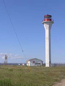 Lighthouse at Point Escuminac, Miramichi Bay, New Brunswick | |
 New Brunswick | |
| Location |
Point Escuminac New Brunswick Canada |
|---|---|
| Coordinates | 47°4′22.86″N 64°47′52.51″W / 47.0730167°N 64.7979194°W |
| Year first constructed | 1841 (first) |
| Year first lit | 1966 (current) |
| Automated | 1989 |
| Deactivated | 1966 (first) |
| Foundation | concrete base |
| Construction |
concrete tower (current) wooden tower (first) |
| Tower shape |
hexagonal prism with flared top supporting balcony and lantern (current) octagonal prism tower (first) |
| Markings / pattern |
white tower, red lantern (current) white tower (first) |
| Height | 22 metres (72 ft) (current) |
| Focal height |
22.2 metres (73 ft) (current) 21.3 metres (70 ft) (first) |
| Light source | main power |
| Range | 13 nautical miles (24 km; 15 mi)[1] |
| Characteristic | Fl W 3s. |
| Fog signal | two 3s. blast every 60s. |
| Admiralty number | H1424 |
| CHS number | CCG 1163 |
| NGA number | 7580 |
| ARLHS number | CAN-389 |
| Managing agent | Canadian Coast Guard[2][3] |
Point Escuminac is a cape located in eastern New Brunswick, Canada. Its geographic coordinates are 47º04'N, 64º48'W.
It is the dividing point for delineating the western limits of the Northumberland Strait. It is located near the unincorporated fishing community of Escuminac, at the mouth of Miramichi Bay.
See also
References
- ↑ List of Lights, Pub. 110: Greenland, The East Coasts of North and South America (Excluding Continental U.S.A. Except the East Coast of Florida) and the West Indies (PDF). List of Lights. United States National Geospatial-Intelligence Agency. 2015.
- ↑ Northern New Brunswick The Lighthouse Directory. University of North Carolina at Chapel Hill. Retrieved 27 March 2017
- ↑ Point Escuminac, NB Lighthouse Friends. Retrieved 27 March 2017
External links
- Point Escuminac, NB Lighthouse Friends
- Aids to Navigation Canadian Coast Guard
Coordinates: 47°04′N 64°48′W / 47.067°N 64.800°W
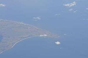
Aerial photo of Point Escuminac
This article is issued from
Wikipedia.
The text is licensed under Creative Commons - Attribution - Sharealike.
Additional terms may apply for the media files.