Poblacion III, Cabuyao
| Barangay III Poblacion Barangay Poblacion Tres Cabuyao, Laguna, Philippines | ||
|---|---|---|
| Barangay | ||
| ||
| Nickname(s): Barangay Tres, Poblacion Tres | ||
| Country |
| |
| Region | CALABARZON (Region IV-A) | |
| Province | Laguna | |
| Municipality | Cabuyao | |
| Incorporated (settlement) | 1571 | |
| Government | ||
| • Type | Sangguniang Barangay, with Chairman as its head supported by seven (7) Barangay Councilors | |
| • Barangay Chairman | Ramon A. Refrea | |
| Area | ||
| • Barangay | 0.2365 km2 (0.0913 sq mi) | |
| Population (May 2010) | ||
| • Barangay | 2,846 | |
| • Density | 12,000/km2 (31,000/sq mi) | |
| • Urban | 2,846 | |
| Time zone | UTC+8 (PST) | |
| • Summer (DST) | Manila | |
| Zip Code | 4025 | |
| Area code(s) | 049 | |
| Languages | Tagalog and English | |

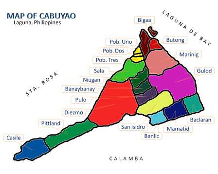
Barangay III Poblacion or Barangay Poblacion III (or simply Barangay Tres) (PSGC: 043404002) is one of the eighteen (18) urbanized[1] barangays comprising the municipality of Cabuyao in the province of Laguna, Philippines. It is one of the three (3) Poblacion barangays of the municipality. According to the 2010 Census,[2] it has a population of 2,846 inhabitants (from 3,153 in Census 2007[3]), ranking 13th when it comes to population. Barangay III is part of the Town Proper or the Business District of Cabuyao, it is the center of commercial and business establishments, Supermarkets and Schools that can be found in Cabuyao.
Barangay III is the home of the only Government Hospital in Cabuyao, the Ospital ng Cabuyao (OnC) and the Cabuyao National Highschool.
Geography
Location
It is located north of Brgy. Sala, east of Brgy. I, south of Brgy. Bigaa and west of Brgy. Sala in Cabuyao, Laguna
It is also one of the three (3) Poblacion barangays of the town while the others are Brgy. I and Brgy. II.[4]
Climate
Types of Seasons
The rainfall regime of Barangay Tres is characterized by the two (2) pronounced seasons, the wet and dry seasons. The wet season which is from June to November and the relatively dry season that lasts from December to May. The average rainfall is about 2,000 mm of rain falling in an average year, there are about 150 days which are rainy days.[5]
Temperature
The seasonal variations of the Temperature field is uneventful. The coldest months start from November up to January and the warmest month on the record is the month of May. On the average, a 12 °C temperature difference exists between the warmest and coolest months. The mean annual temperature is a warm 27.5 °C.[5]
Humidity
The annual relative Humidity is 70%. The most humid months are June, July, August and September with the normal relative humidity registered at 84%, while April and May are the driest at 70%.[5]
Demography
According to 2010 Census,[2] it has a population of 2,846 inhabitants, from 3,153 in Census 2007.[3]
| No. | Barangay | Rank | Population (2007) | Population (2010) | Population Density (2010) | Annual Growth Rate (Average) |
|---|---|---|---|---|---|---|
| 1 | Baclaran | 9th | 12,683 | 12,192 | 6,985/km2 | |
| 2 | Banay-Banay | 4th | 17,419 | 21,934 | 7.073/km2 | |
| 3 | Banlic | 7th | 9,707 | 12,675 | 5,511/km2 | |
| 4 | Bigaa | 10th | 8,649 | 10,051 | 4,807/km2 | |
| 5 | Butong | 8th | 12,274 | 12,360 | 7,630/km2 | |
| 6 | Casile | 16th | 1,555 | 2,128 | 669/km2 | |
| 7 | Diezmo | 15th | 2,689 | 2,681 | 1,686/km2 | |
| 8 | Gulod | 11th | 10,127 | 9,417 | 2,304/km2 | |
| 9 | Mamatid | 1st | 37,166 | 50,213 | 19,313/km2 | |
| 10 | Marinig | 2nd | 25,619 | 37,169 | 9,494/km2 | |
| 11 | Niugan | 3rd | 21,993 | 26,807 | 7,615/km2 | |
| 12 | Pittland | 18th | 1,627 | 1,740 | 598/km2 | |
| 13 | Pulo | 6th | 13,193 | 15,124 | 5,041/km2 | |
| 14 | Sala | 12th | 7,491 | 8,275 | 5,353/km2 | |
| 15 | San Isidro | 5th | 15,495 | 18,145 | 5,767/km2 | |
| 16 | Barangay I Poblacion | 14th | 2,589 | 2,839 | 12,334/km2 | |
| 17 | Barangay II Poblacion | 17th | 1,947 | 1,840 | 7,886/km2 | |
| 18 | Barangay III Poblacion | 13th | 3,153 | 2,846 | 12,034/km2 | |
| TOTAL | 6th | 205,376 | 248,436 | 5,700/km2 |
Barangay Officials (2013-2016)
Barangay Captain:Ramon A. Refrea
Sangguniang Barangay Members:
- Jesusa P. Completo
- Romeo A. Gardon
- Bonifacio N. Castillo
- Alvin D. Meer
- Angelito M. Ponce
- Leopoldo T. Cadag
- Leovigildo B. Demonteverde
See also
References
- ↑ Philippine Standard Geographic Code
- 1 2 "Final Results - 2010 Census of Population". census.gov.ph. Archived from the original on 2012-07-07. Retrieved 2012-06-16.
- 1 2 2007 Census table for Laguna Archived 2011-06-07 at the Wayback Machine. - National Statistics Office
- ↑ Cabuyao, Laguna/Barangay Location Archived 2012-01-28 at the Wayback Machine.
- 1 2 3 Cabuyao, Laguna/Physical Characteristics Archived 2010-10-29 at the Wayback Machine.
External links
Places adjacent to Poblacion III, Cabuyao | ||||||||||
|---|---|---|---|---|---|---|---|---|---|---|
| ||||||||||
| Geography |
|  | |||
|---|---|---|---|---|---|
| City | |||||
| Officials | |||||
| History |
| ||||
| Barangays | |||||
| Notable people | |||||
| |||||
| Aplaya | |
|---|---|
| Central District | |
| Mamatid District | |
| West District | |
| City Proper District | |
Barangays in italics are unofficial
| |
Coordinates: 14°16′42″N 121°7′29″E / 14.27833°N 121.12472°E