Butong, Cabuyao
| Barangay Butong City of Cabuyao | ||
|---|---|---|
| Barangay | ||
| ||
| Nickname(s): Nayon ng Butong, Barrio Butong | ||
| Country |
| |
| Region | CALABARZON (Region IV-A) | |
| Province | Laguna | |
| City | Cabuyao | |
| Incorporated (settlement) | 1571 | |
| Incorporated (barangay) | 1997 | |
| Government | ||
| • Type | Sangguniang Barangay, with Chairman as its head supported by seven (7) Barangay Councilors | |
| • Barangay Chairman | Eugenio E. Rosal | |
| Area | ||
| • Barangay | 1.62 km2 (1.00387 sq mi) | |
| • Urban | 2.6 km2 (1.00387 sq mi) | |
| Population (May 2010) | ||
| • Barangay | 12,360 | |
| • Density | 7,600/km2 (12,000/sq mi) | |
| • Urban | 12,360 | |
| • Urban density | 4,800/km2 (12,000/sq mi) | |
| Time zone | UTC+8 (PST) | |
| • Summer (DST) | Manila | |
| Zip Code | 4025 | |
| Area code(s) | 049 | |
| Languages | Tagalog and English | |
| Demonym | Butongeños | |

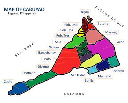
Barangay Butong is one of the eighteen (18) urbanized[1] barangays comprising the City of Cabuyao in the province of Laguna, Philippines. It lies about 3 kilometres (2 mi) away from the centre of Cabuyao and is in the northern portion of the city. According to the 2010 Census, it has a population of 12,360 making it the 8th largest barangay in Cabuyao in terms of population.
Demography
According to the 2010 Census,[2] it has a population of 12,360 inhabitants, up from 12,274 in the 2007 Census.
| No. | Barangay | Rank | Population (2007) | Population (2010) | Population Density (2010) | Annual Growth Rate (Average) |
|---|---|---|---|---|---|---|
| 1 | Baclaran | 9th | 12,683 | 12,192 | 6,985/km2 | |
| 2 | Banay-Banay | 4th | 17,419 | 21,934 | 7.073/km2 | |
| 3 | Banlic | 7th | 9,707 | 12,675 | 5,511/km2 | |
| 4 | Bigaa | 10th | 8,649 | 10,051 | 4,807/km2 | |
| 5 | Butong | 8th | 12,274 | 12,360 | 7,630/km2 | |
| 6 | Casile | 16th | 1,555 | 2,128 | 669/km2 | |
| 7 | Diezmo | 15th | 2,689 | 2,681 | 1,686/km2 | |
| 8 | Gulod | 11th | 10,127 | 9,417 | 2,304/km2 | |
| 9 | Mamatid | 1st | 37,166 | 50,213 | 19,313/km2 | |
| 10 | Marinig | 2nd | 25,619 | 37,169 | 9,494/km2 | |
| 11 | Niugan | 3rd | 21,993 | 26,807 | 7,615/km2 | |
| 12 | Pittland | 18th | 1,627 | 1,740 | 598/km2 | |
| 13 | Pulo | 6th | 13,193 | 15,124 | 5,041/km2 | |
| 14 | Sala | 12th | 7,491 | 8,275 | 5,353/km2 | |
| 15 | San Isidro | 5th | 15,495 | 18,145 | 5,767/km2 | |
| 16 | Barangay I Poblacion | 14th | 2,589 | 2,839 | 12,334/km2 | |
| 17 | Barangay II Poblacion | 17th | 1,947 | 1,840 | 7,886/km2 | |
| 18 | Barangay III Poblacion | 13th | 3,153 | 2,846 | 12,034/km2 | |
| TOTAL | 6th | 205,376 | 248,436 | 5,700/km2 |
See also
References
- ↑ Philippine Standard Geographic Code Archived November 14, 2011, at the Wayback Machine.
- ↑ "Final Results - 2010 Census of Population". census.gov.ph. Archived from the original on 2012-07-07. Retrieved 2012-06-16.
External links
Places adjacent to Butong, Cabuyao | ||||||||||
|---|---|---|---|---|---|---|---|---|---|---|
| ||||||||||
| Aplaya | |
|---|---|
| Central District | |
| Mamatid District | |
| West District | |
| City Proper District | |
Barangays in italics are unofficial
| |
| Geography |
|  | |||
|---|---|---|---|---|---|
| City | |||||
| Officials | |||||
| History |
| ||||
| Barangays | |||||
| Notable people | |||||
| |||||
Coordinates: 14°16′42″N 121°7′29″E / 14.27833°N 121.12472°E
This article is issued from
Wikipedia.
The text is licensed under Creative Commons - Attribution - Sharealike.
Additional terms may apply for the media files.