Sala, Cabuyao
| Barangay Sala City of Cabuyao | |
|---|---|
| Urbanized Barangay | |
 Cabuyao City Hall | |
| Nickname(s): Nayon ng Sala, Barrio Sala | |
| Country |
|
| Region | CALABARZON (Region IV-A) |
| Province | Laguna |
| City | Cabuyao |
| Incorporated (settlement) | 1571 |
| Government | |
| • Type | Sangguniang Barangay, with Chairman as its head supported by seven (7) Barangay Councilors |
| • Barangay Chairman | Francisco J. Alimagno |
| Area | |
| • Urbanized Barangay | 1.54 km2 (0.59 sq mi) |
| Population (May 2010) | |
| • Urbanized Barangay | 8,275 |
| • Density | 5,400/km2 (14,000/sq mi) |
| • Urban | 8,275 |
| Time zone | UTC+8 (PST) |
| • Summer (DST) | Manila |
| Zip Code | 4025 |
| Area code(s) | 049 |
| Languages | Tagalog and English |
| Demonym | Salaeños |
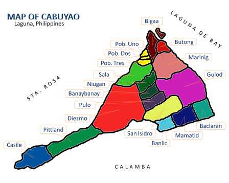
Barangay Sala (PSGC: 043404014) is one of the eighteen (18) urbanized[1] barangays comprising the City of Cabuyao in the province of Laguna, Philippines. It lies for about a half kilometer away from the city proper of Cabuyao and is situated along the national highway. According to the 2010 Census,[2] it has a population of 8,275 inhabitants (grew from 7,491 in Census 2007[3]), making it ranked as 12th largest barangay in Cabuyao when it comes to population.
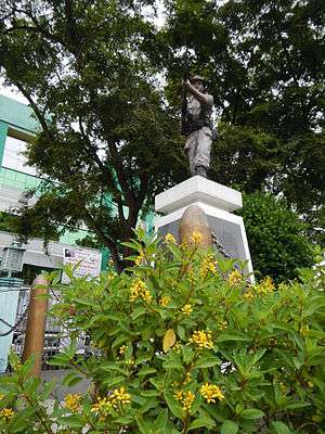
Asia Brewery, Inc. and Tanduay Distillers, Inc., two of the biggest companies and factories in Cabuyao are located in this barangay. It homes the Eton City Exit (formerly ABI Exit) from the South Luzon Expressway and the Eton City Central Business District. It is also the Government Center of Cabuyao, it homes the Cabuyao City Hall, Cabuyao City Police Station, Cabuyao City Jail and Cabuyao Fire Station.
Demography
According to 2010 Census,[2] it has a population of 8,275 inhabitants, grew from 7,491 in Census 2007.[3]
| No. | Barangay | Rank | Population (2007) | Population (2010) | Population Density (2010) | Annual Growth Rate (Average) |
|---|---|---|---|---|---|---|
| 1 | Baclaran | 9th | 12,683 | 12,192 | 6,985/km2 | |
| 2 | Banay-Banay | 4th | 17,419 | 21,934 | 7.073/km2 | |
| 3 | Banlic | 7th | 9,707 | 12,675 | 5,511/km2 | |
| 4 | Bigaa | 10th | 8,649 | 10,051 | 4,807/km2 | |
| 5 | Butong | 8th | 12,274 | 12,360 | 7,630/km2 | |
| 6 | Casile | 16th | 1,555 | 2,128 | 669/km2 | |
| 7 | Diezmo | 15th | 2,689 | 2,681 | 1,686/km2 | |
| 8 | Gulod | 11th | 10,127 | 9,417 | 2,304/km2 | |
| 9 | Mamatid | 1st | 37,166 | 50,213 | 19,313/km2 | |
| 10 | Marinig | 2nd | 25,619 | 37,169 | 9,494/km2 | |
| 11 | Niugan | 3rd | 21,993 | 26,807 | 7,615/km2 | |
| 12 | Pittland | 18th | 1,627 | 1,740 | 598/km2 | |
| 13 | Pulo | 6th | 13,193 | 15,124 | 5,041/km2 | |
| 14 | Sala | 12th | 7,491 | 8,275 | 5,353/km2 | |
| 15 | San Isidro | 5th | 15,495 | 18,145 | 5,767/km2 | |
| 16 | Barangay I Poblacion | 14th | 2,589 | 2,839 | 12,334/km2 | |
| 17 | Barangay II Poblacion | 17th | 1,947 | 1,840 | 7,886/km2 | |
| 18 | Barangay III Poblacion | 13th | 3,153 | 2,846 | 12,034/km2 | |
| TOTAL | 6th | 205,376 | 248,436 | 5,700/km2 |
Barangay Officials (2013-2016)
Barangay Captain: Francisco D. Alimagno
Sangguniang Barangay Members:
- Mark Lezter B. Alimagno
- Rowell L. Hercia
- Tomas J. Jiao, Jr.
- Rosauro G. Saturno
- Rafael S. Alimagno
- Paulo C. Punongbayan
- John L. Barundia
See also
References
- ↑ Philippine Standard Geographic Code
- 1 2 "Final Results - 2010 Census of Population". census.gov.ph. Archived from the original on 2012-07-07. Retrieved 2012-06-16.
- 1 2 2007 Census table for Laguna Archived 2011-06-07 at the Wayback Machine. - National Statistics Office
External links
| Wikimedia Commons has media related to Sala, Cabuyao. |
| Wikipedia has pages related to Sala, Cabuyao under the category of Barangay Sala, Cabuyao, Laguna |
Places adjacent to Sala, Cabuyao | ||||||||||
|---|---|---|---|---|---|---|---|---|---|---|
| ||||||||||
| Aplaya | |
|---|---|
| Central District | |
| Mamatid District | |
| West District | |
| City Proper District | |
Barangays in italics are unofficial
| |
| Geography |
|  | |||
|---|---|---|---|---|---|
| City | |||||
| Officials | |||||
| History |
| ||||
| Barangays | |||||
| Notable people | |||||
| |||||
Coordinates: 14°16′42″N 121°7′29″E / 14.27833°N 121.12472°E