Plymouth Municipal Airport (Massachusetts)
| Plymouth Municipal Airport | |||||
|---|---|---|---|---|---|
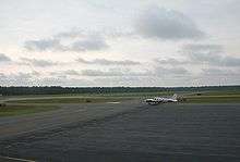 A private plane on the airport's main ramp | |||||
| Summary | |||||
| Airport type | Public | ||||
| Owner | Town of Plymouth | ||||
| Serves | Plymouth County, Massachusetts | ||||
| Elevation AMSL | 148 ft / 45 m | ||||
| Coordinates | 41°54′32″N 070°43′44″W / 41.90889°N 70.72889°W | ||||
| Website | pymairport.com | ||||
| Statistics (2009) | |||||
| |||||
Plymouth Municipal Airport (IATA: PYM, ICAO: KPYM, FAA LID: PYM) is a town-owned, public-use airport located four nautical miles (7 km) southwest of the central business district of Plymouth, a town in Plymouth County, Massachusetts, United States.[1] According to the FAA's National Plan of Integrated Airport Systems for 2009–2013, it is categorized as a general aviation airport.[2] Due to space issues, the airport has 2 gates in Carver, Massachusetts.
Facilities and aircraft
Plymouth Municipal Airport covers an area of 758 acres (307 ha) at an elevation of 148 feet (45 m) above mean sea level.[1]
| Runway 6/24 Information[3] | ||
|---|---|---|
| Dimensions | 4350 x 75 ft. / 1326 x 23 m | |
| Surface | asphalt, in good condition. | |
| Weight Bearing Capacity | Single Wheel: 25.0 | |
| Runway Edge Lights | Medium Intensity | |
| Runway 6 | Runway 24 | |
| Latitude | 41-54.254138N | 41-54.806325N |
| Longitude | 070-44.191108W | 070-43.580575W |
| Elevation(MSL) | 135.1 ft | 146.8 ft |
| Gradient | 0.4% | 0.4% |
| Traffic Pattern | Left | Left |
| Runway Heading | 056 magnetic
040 true |
236 magnetic
220 true |
| Declared Distances | TORA: 4350 TODA: 4350 | TORA: 4350 TODA: 4350
ASDA: 4350 LDA: 4350 |
| Markings | Precision, in good condition | Non-Precision, in good condition |
| Visual Slope Indicator | 4-light PAPI on left
(3.00 degrees glide path) |
4-light PAPI on left
(4.00 degrees glide path) |
| Approach Lights | MALSF: 1,400 foot medium intensity
approach lighting system with sequenced flashers. |
|
| Runway End Identifier Lights | Yes | |
| Touchdown Point | Yes, no lights | Yes, no lights |
| Instrument Approach | ILS/DME, RNAV (GPS) | RNAV (GPS) |
| Obstructions | 30 foot trees, 1700 feet from runway | 65 foot trees, 1,500 feet from runway, 20:1 slope to clear. |
| Runway 15/33 Information[3] | ||
|---|---|---|
| Dimensions | 4350 x 75 ft. / 1326 x 23 m | |
| Surface | asphalt, in good condition. | |
| Weight Bearing Capacity | Single Wheel: 60.0
Double Wheel: 85.0 Double Tandem: 155.0 | |
| Runway Edge Lights | Medium Intensity | |
| Runway 15 | Runway 33 | |
| Latitude | 41-54.732080N | 41-54.275500N |
| Longitude | 070-43.805838W | 070-43.066833W |
| Elevation(MSL) | 144.9 ft | 133.4 ft |
| Gradient | 0.4% | 0.4% |
| Traffic Pattern | Left | Left |
| Runway Heading | 146 magnetic
130 true |
326 magnetic
310 true |
| Declared Distances | TORA: 4350 TODA: 4350 | TORA: 4350 TODA: 4350 |
| Markings | Basic, in good condition | Basic, in good condition |
| Visual Slope Indicator | 4-light PAPI on left
(3.00 degrees glide path) | |
| Touchdown Point | Yes, no lights | Yes, no lights |
| Obstructions | 27 ft. trees, 750 ft. from runway,
125 ft. left of centerline, 20:1 slope to clear. |
80 ft. tree, 1800 ft. from runway,
125 ft. left of centerline, 20:1 slope to clear. |
| Airport Services[3] | |
|---|---|
| Fuel | 100LL, Jet-A |
| Parking | Aircraft hangars and Tiedowns |
| Airframe Service | Major |
| Powerplant Service | Magor |
| Bottled Oxygen | Low |
| Bulk Oxygen | Low |
| Airport Communications[3] | |
|---|---|
| CTAF/UNICOM | 123.0 |
| WX ASOS | 135.625
(508) 746-8003 |
| CLEARANCE DELIVERY* | 127.75 |
| CAPE APPROACH/DEPARTURE* | 118.2 |
| PILOT CONTROLLED LIGHTING | 122.900 |
| * NOTE: APCH/DEP SERVICES PROVIDED BY BOSTON CENTER
ON 128.75 WHEN CAPE APPROACH IS CLOSED. | |
For the 12-month period ending July 14, 2016, the airport had an average of 139 operations per day. 59% local general aviation, 39% transient general aviation, 1% air taxi, and <1% military. At that time there were 114 aircraft based at this airport: 96 single-engine, 8 multi-engine, 6 jets and 4 helicopters.[1][3]
Gallery
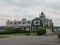 General aviation terminal
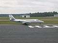 Charter plane at the airport
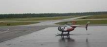 Helicopter on the airport ramp
References
- 1 2 3 4 FAA Airport Master Record for PYM (Form 5010 PDF). Federal Aviation Administration. Effective 8 April 2010.
- ↑ National Plan of Integrated Airport Systems for 2009–2013: Appendix A: Part 3 (PDF, 1.28 MB) Archived 2011-06-06 at the Wayback Machine.. Federal Aviation Administration. Updated 15 October 2008.
- 1 2 3 4 5 "AirNav: KPYM - Plymouth Municipal Airport". www.airnav.com. Retrieved 2017-12-02.
External links
- Aerial photo as of 10 March 1995 from USGS The National Map via MSR Maps
- FAA Terminal Procedures for PYM, effective October 11, 2018
- Resources for this airport:
- FAA airport information for PYM
- AirNav airport information for KPYM
- ASN accident history for PYM
- FlightAware airport information and live flight tracker
- NOAA/NWS latest weather observations
- SkyVector aeronautical chart, Terminal Procedures