Plessis, New York
| Plessis, New York | |
|---|---|
| Census-designated place | |
 Plessis  Plessis | |
| Coordinates: 44°16′13″N 75°51′16″W / 44.27028°N 75.85444°WCoordinates: 44°16′13″N 75°51′16″W / 44.27028°N 75.85444°W | |
| Country | United States |
| State | New York |
| County | Jefferson |
| Town | Alexandria |
| Area[1] | |
| • Total | 0.346 sq mi (0.90 km2) |
| • Land | 0.346 sq mi (0.90 km2) |
| • Water | 0 sq mi (0 km2) |
| Elevation | 404 ft (123 m) |
| Population (2010)[1] | |
| • Total | 164 |
| • Density | 470/sq mi (180/km2) |
| Time zone | UTC-5 (Eastern (EST)) |
| • Summer (DST) | UTC-4 (EDT) |
| ZIP code | 13675 |
| Area code(s) | 315 & 680 |
| GNIS feature ID | 960751[2] |
Plessis is a hamlet and census-designated place in the town of Alexandria in Jefferson County, New York, United States. Its population was 164 as of the 2010 census.[1] Plessis had a post office from September 16, 1823, until March 26, 2011; it still has its own ZIP code, 13675.[3][4] New York State Route 26 passes through the community.
Geography
According to the U.S. Census Bureau, the community has an area of 0.346 square miles (0.90 km2), all of it land.[1]
References
- 1 2 3 4 "2010 Census Gazetteer Files - Places: New York". U.S. Census Bureau. Retrieved April 6, 2017.
- ↑ "Plessis". Geographic Names Information System. United States Geological Survey.
- ↑ United States Postal Service. "USPS - Look Up a ZIP Code". Retrieved April 6, 2017.
- ↑ "Postmaster Finder - Post Offices by ZIP Code". United States Postal Service. Retrieved April 6, 2017.
Municipalities and communities of Jefferson County, New York, United States | ||
|---|---|---|
| City | 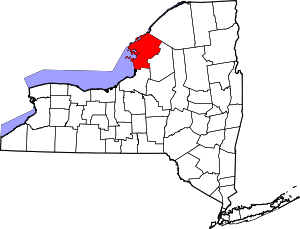 | |
| Towns | ||
| Villages | ||
| CDPs | ||
| Hamlets | ||
This article is issued from
Wikipedia.
The text is licensed under Creative Commons - Attribution - Sharealike.
Additional terms may apply for the media files.