Pittwater Council
| Pittwater Council New South Wales | |||||||||||||||
|---|---|---|---|---|---|---|---|---|---|---|---|---|---|---|---|
 Location in Metropolitan Sydney | |||||||||||||||
| Coordinates | 33°40′39″S 151°18′14″E / 33.6776°S 151.3039°ECoordinates: 33°40′39″S 151°18′14″E / 33.6776°S 151.3039°E | ||||||||||||||
| Population | 57,155 (2011 census)[1] | ||||||||||||||
| • Density | 628.1/km2 (1,627/sq mi) | ||||||||||||||
| Established | 1 May 1992 | ||||||||||||||
| Abolished | 12 May 2016 | ||||||||||||||
| Area | 91 km2 (35.1 sq mi) | ||||||||||||||
| Mayor | Jacqui Townsend (Independent) | ||||||||||||||
| Council seat | Mona Vale Memorial Hall | ||||||||||||||
| Region | Metropolitan Sydney | ||||||||||||||
| State electorate(s) | Pittwater | ||||||||||||||
| Federal Division(s) | Mackellar | ||||||||||||||
|
| |||||||||||||||
| Website | Pittwater Council | ||||||||||||||
| |||||||||||||||
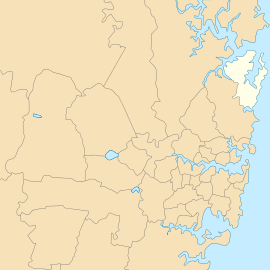
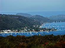
Pittwater Council was a local government area on the Northern Beaches of Sydney, in the state of New South Wales, Australia. It covered a region adjacent to the Tasman Sea about 30 kilometres (19 mi) north of the Sydney central business district. The area is named after Pittwater, the body of water adjacent to much of the area governed. On 12 May 2016, the Minister for Local Government announced that Pittwater Council would be subsumed into the newly formed Northern Beaches Council.[2]

The Mayor of Pittwater Council was Councillor Jacqui Townsend, an independent politician.
Suburbs and localities
Suburbs and localities serviced by Pittwater Council were:
- Akuna Bay
- Avalon Beach
- Avalon North
- Barrenjoey
- Bayview
- Bilgola Beach
- Bilgola Plateau
- Bungan Beach
- Bungan Head
- Careel Bay
- Careel Head
- Church Point
- Clareville
- Clareville Beach
- Coasters Retreat
- Currawong Beach
- Elanora Heights
- Elvina Bay
- Foleys Hill
- Great Mackerel Beach
- Ingleside
- Ingleside Heights
- Loquat Valley
- Lovett Bay
- McCarrs Creek
- Mona Vale
- Morning Bay
- Narrabeen
- Newport
- North Narrabeen
- Palm Beach
- Paradise Beach
- Salt Pan Cove
- Sand Point
- Scotland Island
- South Warriewood
- Stokes Point
- Taylors Point
- The Basin
- Towlers Bay
- Tumbledown Dick
- Turimetta
- Warriewood
- Warriewood Beach
- Whale Beach
Demographics
At the 2011 Census, there were 57,155 people in the Pittwater local government area, of these 48.8% were male and 51.2% were female. Aboriginal and Torres Strait Islander people made up 0.4% of the population. The median age of people in the Pittwater Council area was 42 years; notably above the national median of 37 years. Children aged 0 – 14 years made up 20.0% of the population and people aged 65 years and over made up 17.0% of the population. Of people in the area aged 15 years and over, 56.1% were married and 11.0% were either divorced or separated.[1]
Population growth in the Pittwater Council area between the 2001 Census and the 2006 Census was 3.40% and in the subsequent five years to the 2011 Census, population growth was 5.54%. When compared with total population growth of Australia for the same periods, being 5.78% and 8.32% respectively, population growth in the Pittwater local government area was lower than the national average.[3] The median weekly income for residents within the Pittwater Council area was higher than the national average.[1]
At the 2011 Census, the proportion of residents in the Pittwater local government area who stated their ancestry as Australian or Anglo-Saxon exceeded 75% of all residents (national average was 65.2%). In excess of 57% of all residents in the Pittwater Council area nominated a religious affiliation with Christianity at the 2011 Census, which was slightly higher than the national average of 50.2%. Meanwhile, as at the Census date, compared to the national average, households in the Pittwater local government area had a significantly lower than average proportion (10.8%) where two or more languages are spoken (national average was 20.4%); and a significantly higher proportion (88.7%) where English only was spoken at home (national average was 76.8%).[1]
| Selected historical census data for Pittwater local government area | |||||
|---|---|---|---|---|---|
| Census year | 2001[3] | 2006[4] | 2011[1] | ||
| Population | Estimated residents on Census night | 52,376 | 54,157 | 57,155 | |
| LGA rank in terms of size within New South Wales | |||||
| % of New South Wales population | 0.83% | ||||
| % of Australian population | 0.28% | ||||
| Cultural and language diversity | |||||
| Ancestry, top responses | Australian | 26.7% | |||
| English | 32.0% | ||||
| Irish | 8.7% | ||||
| Scottish | 7.8% | ||||
| German | 3.0% | ||||
| Language, top responses (other than English) | German | 0.8% | |||
| Italian | 0.8% | ||||
| Serbian | 0.6% | ||||
| Spanish | n/c | ||||
| Croatian | 0.5% | ||||
| Religious affiliation | |||||
| Religious affiliation, top responses | Catholic | 22.4% | |||
| Anglican | 29.5% | ||||
| No religion | 17.5% | ||||
| Uniting Church | 5.1% | ||||
| Presbyterian and Reformed | 3.6% | ||||
| Median weekly incomes | |||||
| Personal income | Median weekly personal income | A$653 | A$754 | ||
| % of Australian median income | 140.1% | 130.7% | |||
| Family income | Median weekly family income | A$1,486 | A$2,137 | ||
| % of Australian median income | 144.7% | 144.3% | |||
| Household income | Median weekly household income | A$1,767 | A$1,819 | ||
| % of Australian median income | 150.9% | 147.4% | |||
Council
Mayors/Deputy Mayors
| Order | Mayor | Term begin | Term end | Deputy Mayors | Year |
|---|---|---|---|---|---|
| 1 | Eric Green[5] | 1 May 1992 | 24 October 1992 | Ross Bonthorne | 1992 |
| 2 | Robert Dunn | 24 October 1992 | September 1994 | Allan Porter | 1992–1993 |
| ???? | 1993 – 1994 | ||||
| 3 | Ron Starr | September 1994 | September 1997 | John Winter | 1994 – 1995 |
| ???? | 1995 – 1996 | ||||
| Shirley Phelps[6] | 1996 – 1997 | ||||
| 4 | Patricia Giles | September 1997 | September 2004 | Bob Dunbar | 1997 – 1998 |
| Julie Hegarty | 1998 – 1999 | ||||
| Lynne Czinner | 1999 – 2002 | ||||
| David James | 2002 – 2004 | ||||
| 5 | Lynne Czinner | September 2004 | 12 September 2005 | David James | 2004 – 2005 |
| 6 | Alex McTaggart[7] | 12 September 2005 | September 2007 | Patricia Giles | 2005 – 2009 |
| 7 | David James[8] | September 2007 | September 2009 | ||
| 8 | Harvey Rose | September 2009 | September 2012 | Jacqueline Townsend | 2009 – 2011 |
| Ian White | 2011 – 2012 | ||||
| 9 | Jacqueline Townsend | September 2012 | 12 May 2016 | Bob Grace | 2012 – 2013 |
| Kylie Ferguson | 2013 – 2016 |
Final composition and election method
Pittwater Council was composed of nine Councillors elected proportionally as three separate wards, each electing three Councillors. All Councillors were elected for a fixed four-year term of office. The Mayor and Deputy Mayor were elected annually by the Councillors at the first meeting of the Council. The last election was held on 8 September 2012, and the makeup of the Council was as follows when it was dissolved:[9][10][11]
| Ward | Councillor | Party | Notes | |
|---|---|---|---|---|
| Central Ward[9] | Sue Young | Independent | ||
| Ian White | Independent | Elected to Northern Beaches Pittwater Ward, 2017. | ||
| Kylie Ferguson | Independent | Deputy Mayor, 2013–2016. Elected to Northern Beaches Pittwater Ward, 2017. | ||
| North Ward[10] | Bob Grace | Independent | Deputy Mayor, 2012–2013 | |
| Alex McTaggart | Independent | Mayor, 2005–2007.[7] Elected to Northern Beaches Pittwater Ward, 2017. | ||
| Selena Griffith | Greens | |||
| South Ward[11] | Jacqueline Townsend | Independent | Mayor 2012–2016[12] | |
| Julie Hegarty | Independent | Deputy Mayor, 1998–1999 | ||
| Kay Millar | Independent | |||
General Managers
| Name | Term | Notes |
|---|---|---|
| Brian Hrnjak | 1 May 1992 – 1997 | [13][14] |
| Angus Gordon | 1997 – September 2005 | [15] |
| Mark Ferguson | September 2005 – 12 May 2016 | General Manager of Northern Beaches Council, 2017. |
History
The Pittwater Shire was named after an estuary of Broken Bay which the shire surrounds. Broken Bay forms the mouth of the Hawkesbury River, the main river which formed the Cumberland Plain and Sydney basin. Pittwater was discovered in 1788, the year the first British colony was established in Australia. However, Pittwater and the surrounding region was inhabited for many millennia by local Aboriginal tribes and much evidence of their habitation remains especially their rock etchings in Kuring-gai Chase National Park which borders Pittwater's western side. Pittwater was named in about 1800 by the colony's first Governor, Arthur Phillip, honouring the then British Prime Minister, William Pitt the Younger.[16]
Pittwater in the early 19th century was developed as a new port with loading and unloading facilities erected at what is now the current Newport public wharf. As the port developed so did local industry such as sheep at Mona Vale, orchards at southern Newport and Church Point, salt from Saltpan cove and Scotland Island. During the period from the 1950s to the early 1970s, sand mining operations were undertaken in the upper reaches of McCarr's Creek. After sand mining operations ceased, the tailings ponds were all that remained of the mining operation. Around the 1850s a school was established on the site of what is now Newport Public school. Over later periods, public (primary) schools were established at Mona Vale, Avalon and Bilgola Plateau. In 1963, Pittwater High School was opened at Mona Vale (located on Pittwater Road), Barrenjoey High School (located at the northern end of Avalon beach) was opened in 1968. During the Second World War, unlike Sydney Harbour (Port Jackson), Pittwater was not protected by a boom net. As a consequence local militia and later Australian Army were stationed at the western side of the entrance to Pittwater and were dispersed along the western shore in a network of trenches, pillboxes and gun emplacements.
Pittwater was first incorporated in 1906 when it was included as the "A Riding" of Warringah Shire Council. However for many years there existed a sentiment held by some in A Riding, the northern Riding and the largest in Warringah, taking up more than 40% of Warringah's land area, that they were being increasingly ignored and subject to what they considered inappropriate development and policies for their area.[17] This culminated in 1991 when a non-compulsory postal poll of the residents of A Riding was taken over the question of a possible secession. This resulted in a 73.5% vote in favour of secession, however only 48.18% of residents took part in this vote. This vote was, however, 600 short of the total majority required.
The Minister for Local Government at the time, Gerry Peacocke, nevertheless announced the secession of A Riding from Warringah Council, considering that those who did not vote did not have any particular inclination to how they were governed, and thus Pittwater Council was created.[17] On 1 May 1992, The Governor of New South Wales, Rear Admiral Peter Sinclair, proclaimed the establishment of the Municipality of Pittwater, the area of which roughly followed the area formerly known as ‘A’ Riding of the Warringah Shire.[18] Also on that day, the offices of Robert Dunn, Eric Green and Ronald Starr, former Warringah ‘A’ Riding Councillors, were terminated with those persons forming, with others, a Provisional Council of the Municipality of Pittwater.[19] With the passing of the Local Government Act 1993, the title of the council changed from the Municipality of Pittwater to simply Pittwater Council.
Amalgamation
A 2015 review of local government boundaries by the NSW Government Independent Pricing and Regulatory Tribunal recommended that the Pittwater Council merge with adjoining councils. The government considered two proposals. The first proposed a merger of Pittwater Council and parts of Warringah Council to form a new council with an area of 214 square kilometres (83 sq mi) and support a population of approximately 141,000.[20] The alternative, proposed by Warringah Council on 23 February 2016, was for an amalgamation of the Pittwater, Manly and Warringah councils.[21][22] On 12 May 2016, the council was amalgamated with Manly and Warringah Councils to form the Northern Beaches Council.
Council seal
The seal of Pittwater Council was the result of a design competition held by the council that was won by retired Newport commercial artist Hugh Seelenmeyer. It was first used in the Manly Daily on 29 June 1991 and featured a mangrove tree surrounded by water, representing the close relationship of the area with water and bushland.[23]
Sister cities
Pittwater Council's suburb Mona Vale is sister city to the United States village of Wilmette, Illinois and they participate in an annual student exchange program between their high schools. Pittwater and Wilmette are both home to a Bahá'í House of Worship.[24]
References
- 1 2 3 4 5 Australian Bureau of Statistics (31 October 2012). "Pittwater (A)". 2011 Census QuickStats. Retrieved 8 December 2012.

- ↑ "Northern Beaches Council". Government of New South Wales. 12 May 2016. Retrieved 12 May 2016.
- 1 2 Australian Bureau of Statistics (9 March 2006). "Pittwater (A)". 2001 Census QuickStats. Retrieved 8 December 2012.
- ↑ Australian Bureau of Statistics (25 October 2007). "Pittwater (A)". 2006 Census QuickStats. Retrieved 8 December 2012.
- ↑ Elected mayor of provisional council, 14 November 1991.
- ↑ "QB 2013: MEDAL (OAM) OF THE ORDER OF AUSTRALIA IN THE GENERAL DIVISION - Mrs Shirley Amy PHELPS" (PDF). Governor-General of Australia. Retrieved 28 September 2018.
- 1 2 Served concurrently as the Member for Pittwater "Mr (Alex) Alexander John MCTAGGART (1949 - )". Former Members of Parliament. Parliament of New South Wales. 15 September 2008. Retrieved 16 February 2010.
- ↑ Warringah Councillor, 1980–1983.
- 1 2 "Pittwater Council – Central Ward". Local Government Elections 2012. Electoral Commission of New South Wales. 14 September 2012. Retrieved 22 September 2012.
- 1 2 "Pittwater Council – North Ward". Local Government Elections 2012. Electoral Commission of New South Wales. 14 September 2012. Retrieved 22 September 2012.
- 1 2 "Pittwater Council – South Ward". Local Government Elections 2012. Electoral Commission of New South Wales. 14 September 2012. Retrieved 22 September 2012.
- ↑ Priestley, Andrew (25 September 2012). "Pittwater Mayor Jacqui Townsend on a mission". The Manly Daily. Retrieved 7 December 2012.
- ↑ Wicks, Kathryn (21 May 1992). "Pittwater staff still in limbo". The Sydney Morning Herald. p. 1.
- ↑ "PITTWATER COUNCIL". Government Gazette Of The State Of New South Wales (86). New South Wales, Australia. 6 August 1993. p. 4492. Retrieved 26 November 2017 – via National Library of Australia.
- ↑ "PITTWATER COUNCIL". Government Gazette Of The State Of New South Wales (28). New South Wales, Australia. 21 March 1997. p. 1625. Retrieved 26 November 2017 – via National Library of Australia.
- ↑ Ernest Scott, A Short History of Australia
- 1 2 "Pittwater Library - Pittwater Secession". Pittwater Council. Retrieved 2008-07-19.
- ↑ "LOCAL GOVERNMENT ACT 1919 - PROCLAMATION". Government Gazette Of The State Of New South Wales (36). New South Wales, Australia. 13 March 1992. p. 1677. Retrieved 26 November 2017 – via National Library of Australia.
- ↑ "Presidents, Mayors, Councillors, Shire Clerks and General Managers of Warringah Council" (PDF). Warringah Council. Retrieved 22 May 2009.
- ↑ "Merger proposal: Pittwater Council, Warringah Council (part)" (PDF). Government of New South Wales. January 2016. p. 8. Retrieved 22 February 2016.
- ↑ Warringah Council (23 February 2016). "Manly, Pittwater and Warringah councils Proposal" (PDF). Government of New South Wales. Archived from the original (PDF) on 9 March 2016. Retrieved 27 February 2016.
- ↑ Kembrey, Melanie; Robertson, James (27 February 2016). "Northern Beaches mega council back on the table after merger 'loophole' discovered". The Sydney Morning Herald. Retrieved 28 February 2016.
- ↑ Morcombe, John (11 August 2017). "Aboriginal men, flannel flower and mangrove tree features of earlier versions of council motifs". Manly Daily. Retrieved 26 November 2017.
- ↑ "Sister Cities". Village of Wilmette. Archived from the original on 27 November 2015. Retrieved 18 January 2016.