Pesmes
| Pesmes | |
|---|---|
| Commune | |
      Maison Royale | |
 Pesmes Location within Bourgogne-Franche-Comté region  Pesmes | |
| Coordinates: 47°16′50″N 5°33′56″E / 47.2806°N 5.5656°ECoordinates: 47°16′50″N 5°33′56″E / 47.2806°N 5.5656°E | |
| Country | France |
| Region | Bourgogne-Franche-Comté |
| Department | Haute-Saône |
| Arrondissement | Vesoul |
| Canton | Marnay |
| Area1 | 18.64 km2 (7.20 sq mi) |
| Population (2006)2 | 1,140 |
| • Density | 61/km2 (160/sq mi) |
| Time zone | UTC+1 (CET) |
| • Summer (DST) | UTC+2 (CEST) |
| INSEE/Postal code | 70408 /70140 |
| Elevation | 187–291 m (614–955 ft) |
|
1 French Land Register data, which excludes lakes, ponds, glaciers > 1 km2 (0.386 sq mi or 247 acres) and river estuaries. 2 Population without double counting: residents of multiple communes (e.g., students and military personnel) only counted once. | |
Pesmes is a commune in the Haute-Saône department in the region of Bourgogne-Franche-Comté in eastern France.
See also
References
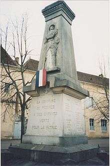
a monument in commemoration of the residents of Pesmes,France, who were killed during World War I
| Wikimedia Commons has media related to Pesmes. |
This article is issued from
Wikipedia.
The text is licensed under Creative Commons - Attribution - Sharealike.
Additional terms may apply for the media files.