Arpenans
| Arpenans | |
|---|---|
| Commune | |
 | |
 Arpenans Location within Bourgogne-Franche-Comté region  Arpenans | |
| Coordinates: 47°37′01″N 6°24′15″E / 47.6169°N 6.4042°ECoordinates: 47°37′01″N 6°24′15″E / 47.6169°N 6.4042°E | |
| Country | France |
| Region | Bourgogne-Franche-Comté |
| Department | Haute-Saône |
| Arrondissement | Lure |
| Canton | Lure-2 |
| Intercommunality | CC Pays Lure |
| Government | |
| • Mayor (2014-2020) | Élisabeth Sieger |
| Area1 | 11.80 km2 (4.56 sq mi) |
| Population (2015)2 | 246 |
| • Density | 21/km2 (54/sq mi) |
| Time zone | UTC+1 (CET) |
| • Summer (DST) | UTC+2 (CEST) |
| INSEE/Postal code | 70029 /70200 |
| Elevation | 271–416 m (889–1,365 ft) |
|
1 French Land Register data, which excludes lakes, ponds, glaciers > 1 km2 (0.386 sq mi or 247 acres) and river estuaries. 2 Population without double counting: residents of multiple communes (e.g., students and military personnel) only counted once. | |
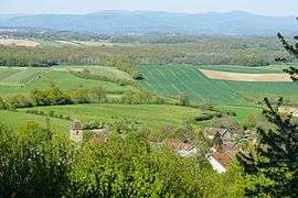
Arpenans is a commune in the Haute-Saône department in the region of Bourgogne-Franche-Comté in eastern France. It lies 19km away from Ronchamp Chapel and Vesoul
See also
References
- INSEE (in English)
| Wikimedia Commons has media related to Arpenans. |
This article is issued from
Wikipedia.
The text is licensed under Creative Commons - Attribution - Sharealike.
Additional terms may apply for the media files.