Chenebier
| Chenebier | |
|---|---|
| Commune | |
 | |
 Chenebier Location within Bourgogne-Franche-Comté region  Chenebier | |
| Coordinates: 47°38′32″N 6°43′10″E / 47.6422°N 6.7194°ECoordinates: 47°38′32″N 6°43′10″E / 47.6422°N 6.7194°E | |
| Country | France |
| Region | Bourgogne-Franche-Comté |
| Department | Haute-Saône |
| Arrondissement | Lure |
| Canton | Héricourt-2 |
| Intercommunality | CC pays d'Héricourt |
| Area1 | 9.05 km2 (3.49 sq mi) |
| Population (2006)2 | 709 |
| • Density | 78/km2 (200/sq mi) |
| Time zone | UTC+1 (CET) |
| • Summer (DST) | UTC+2 (CEST) |
| INSEE/Postal code | 70149 /70400 |
| Elevation | 346–472 m (1,135–1,549 ft) |
|
1 French Land Register data, which excludes lakes, ponds, glaciers > 1 km2 (0.386 sq mi or 247 acres) and river estuaries. 2 Population without double counting: residents of multiple communes (e.g., students and military personnel) only counted once. | |
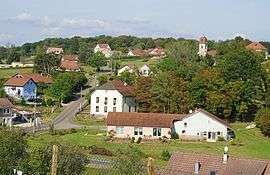
Chenebier is a commune in the Haute-Saône department in the region of Bourgogne-Franche-Comté in eastern France.
See also
Chenebier is a village located in the department of Haute-Saône, itself situated in Franche-Comté (to the East of France). Around 739 inhabitants live there; they are called "Chenaillots" and "Chenaillottes". Chenebier is surrounded by other villages such as Chagey, Echavanne and Etobon. The closest town is Belfort (department of Territoire de Belfort) and is located 10 kilometers away (North-West). The village is some 381-meter high and is close to the Ballon des Vosges Natural Park. The mayor is Lionel Hénisse.
References
- INSEE (in English)
| Wikimedia Commons has media related to Chenebier. |