La Valletta Brianza
| La Valletta Brianza | |
|---|---|
| Comune | |
| Comune di La Valletta Brianza | |
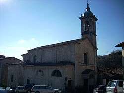 Church of Perego. | |
 La Valletta Brianza Location of La Valletta Brianza in Italy | |
| Coordinates: 45°44′N 9°22′E / 45.733°N 9.367°ECoordinates: 45°44′N 9°22′E / 45.733°N 9.367°E | |
| Country | Italy |
| Region | Lombardy |
| Province | Lecco (LC) |
| Frazioni | i Albareda, Bagaggera, Barbabella, Bernaga, Biscioia, Brugolone, Casternago, Cerè, Cereda, Crescenzaga, Filatoio, Fornace Alta, Fornace Bassa, Francolino, Galbusera Bianca, Galbusera Nera, Lissolo, Malnido, Malpensata, Monte, Molino, Ospedaletto, Perego, Rovagnate, Sara, Spiazzo, Zerbine |
| Government | |
| • Mayor | Roberta Trabucchi |
| Area | |
| • Total | 8.78 km2 (3.39 sq mi) |
| Elevation | 342 m (1,122 ft) |
| Population (30 January 2015)[1] | |
| • Total | 4,691 |
| • Density | 530/km2 (1,400/sq mi) |
| Time zone | UTC+1 (CET) |
| • Summer (DST) | UTC+2 (CEST) |
| Postal code | 23888 |
| Dialing code | 039 |
| Website | Official website |
La Valletta Brianza (Brianzöö: La Valetta [la ʋaˈlɛta]) is a comune in the province of Lecco, Lombardy, northern Italy. It was created on 30 January 2015 when the two former communes o Perego and Rovagnate merged. The communal seat is located in the latter hamlet.
It is located about 35 kilometres (22 mi) northeast of Milan and about 13 kilometres (8 mi) south of Lecco.
References

This article is issued from
Wikipedia.
The text is licensed under Creative Commons - Attribution - Sharealike.
Additional terms may apply for the media files.