Payathonzu
| Payathonzu ဘုရားသုံးဆူမြို့ | |
|---|---|
| Town | |
_-_panoramio_-_Boonchai_C_(12).jpg) | |
 Payathonzu Location in Burma | |
| Coordinates: 15°18′0″N 98°23′0″E / 15.30000°N 98.38333°ECoordinates: 15°18′0″N 98°23′0″E / 15.30000°N 98.38333°E | |
| Country |
|
| Division |
|
| District | Kawkareik District |
| Township | Kyain Seikgyi Township |
| Subtownship | Hpayarthonesu |
| Elevation | 728 ft (222 m) |
| Population (2014) | |
| • Town | 27,311 |
| • Urban | 5,878 |
| • Rural | 21,433 |
| • Religions | Buddhism |
| Time zone | UTC+6.30 (MST) |
| Area code(s) | 58[1] |
Payathonzu (Phlone: ကၠံင်သိုင့်ဖၠုံးဍုံ; Burmese: ဘုရားသုံးဆူမြို့ [pʰəjá θóʊɴzù mjo̰]) is a town in the Karen State of south Myanmar, close to the border with Thailand. Separated from the Thai border township of Nong Lu by the Three Pagodas Pass. It is also the administrative seat of Hpayarthonezu Sub-township (fourth-level administrative division of Myanmar) in Kyain Seikgyi Township, Kawkareik District of Kayin State in Myanmar.[2]
References
- ↑ "Myanmar Area Codes". Retrieved 2009-04-10.
- ↑ "Township map of Kyainseikgyi" (PDF). Myanmar Information Management Unit (MIMU). 3 May 2016. Retrieved 22 November 2017.
External links
- Taravel in Thailand books
Capital: Hpa-an | ||
| Hpa-an District | 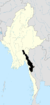 | |
| Hpapun District | ||
| Kawkareik District | ||
| Myawaddy District | ||
| Cities and towns | ||
This article is issued from
Wikipedia.
The text is licensed under Creative Commons - Attribution - Sharealike.
Additional terms may apply for the media files.