Paw Paw, Kentucky
| Paw Paw | |
|---|---|
| Unincorporated community | |
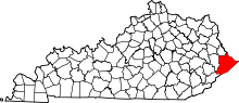
 Paw Paw Location within the state of Kentucky  Paw Paw Paw Paw (the US) | |
| Coordinates: 37°26′15″N 82°6′38″W / 37.43750°N 82.11056°WCoordinates: 37°26′15″N 82°6′38″W / 37.43750°N 82.11056°W | |
| Country | United States |
| State | Kentucky |
| County | Pike |
| Elevation | 984 ft (300 m) |
| Time zone | UTC-5 (Eastern (EST)) |
| • Summer (DST) | UTC-4 (EDT) |
| ZIP codes | 41551 |
| GNIS feature ID | 500279[1] |
Paw Paw is an unincorporated community located in Pike County, Kentucky, United States.
The community was named after the common pawpaw.[2]
References
- ↑ U.S. Geological Survey Geographic Names Information System: Paw Paw, Kentucky
- ↑ Hess, Cameron M. Ludwick & Blair Thomas (30 March 2015). My Old Kentucky Road Trip: Historic Destinations & Natural Wonders. Arcadia Publishing. p. 168. ISBN 978-1-62619-816-6.
This article is issued from
Wikipedia.
The text is licensed under Creative Commons - Attribution - Sharealike.
Additional terms may apply for the media files.