McAndrews, Kentucky
| McAndrews | |
|---|---|
| Unincorporated community | |
 McAndrews Location within the state of Kentucky  McAndrews McAndrews (the US) | |
| Coordinates: 37°34′25″N 82°16′6″W / 37.57361°N 82.26833°WCoordinates: 37°34′25″N 82°16′6″W / 37.57361°N 82.26833°W | |
| Country | United States |
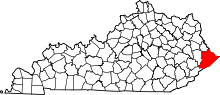
| State | Kentucky |
| County | Pike |
| Elevation | 971 ft (296 m) |
| Time zone | UTC-5 (Eastern (EST)) |
| • Summer (DST) | UTC-4 (EDT) |
| ZIP codes | 41543 |
| GNIS feature ID | 497762[1] |
McAndrews is an unincorporated community in Pike County, Kentucky, United States. Their post office opened in 1921.[2] It was also known as Pinson.
References
This article is issued from
Wikipedia.
The text is licensed under Creative Commons - Attribution - Sharealike.
Additional terms may apply for the media files.