Patongo, Uganda
| Patongo | |
|---|---|
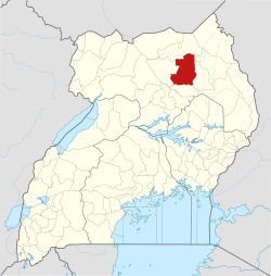
 Patongo Map of Uganda showing the location of Patongo | |
| Coordinates: 02°45′36″N 33°18′36″E / 2.76000°N 33.31000°E | |
| Country |
|
| Region | Northern Region of Uganda |
| Sub-region | Acholi sub-region |
| District | Agago District |
| Elevation | 1,200 m (3,900 ft) |
| Time zone | UTC+3 (EAT) |
Patongo is a town in Agago District, Acholi sub-region in the Northern Region of Uganda. The town is administered by Patongo Town Council
Location
Patongo is approximately 21.5 kilometres (13.4 mi), by road, south of Agago, the site of the district headquarters .[1] The coordinates of the town are 2°45'36.0"N, 33°18'36.0"E (Latitude:2.7600; Longitude:33.3100).[2]
Overview
The town of Patongo was formed during the 2000s along with Pader and Pader District. Initially the location of a large camp for internally displaced people as a result of the Lord's Resistance Army insurgency, Patongo was granted municipal status by the Ugandan parliament effective July 2010.[3] In 2010, when Pader District was divided to create Agago District,[4][5] Patongo went with Agago District.
Points of interest
The following additional points of interest are located within or near the town of Patongo:
See also
References
- ↑ GFC (23 July 2015). "Road Distance Between Patongo And Agago With Map". Globefeed.com (GFC). Retrieved 23 July 2015.
- ↑ Google (23 July 2015). "Location of Patongo At Google Maps" (Map). Google Maps. Google. Retrieved 23 July 2015.
- ↑ Cyprian Musoke, and Joyce Namutebi (1 September 2009). "MPS Warn On New Town Councils". New Vision. Kampala. Archived from the original on 4 September 2009. Retrieved 23 July 2015.
- ↑ Vision Reporters (22 April 2010). "Government Names 14 New Districts". New Vision. Kampala. Archived from the original on 29 October 2013. Retrieved 23 July 2015.
- ↑ Owot, Robert (30 March 2014). "Pader: Where Cotton Is Still A Major Earner". Daily Monitor. Kampala. Retrieved 23 July 2015.
- ↑ Genrwot, Jeddy (27 May 2015). "Meet RootIO: A community radio innovation that uses a cellphone to broadcast". PC Tech Mag. Kampala. Retrieved 8 February 2016.
External links
- Myths And Facts About Northern Uganda - 21 April 2006
- Africa After War: Paths to Forgiveness – Ugandans Welcome 'Terrorists' Back - 23 October 2006
Capital: Agago | ||
| Counties and sub-counties |
|  |
| Towns and villages | ||
| Economy | ||
| Notable landmarks |
| |
| Energy | ||
| Education |
| |
| Notable people | ||