Parasnath railway station
Parasnath | |
|---|---|
| Indian Railway Station | |
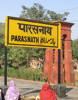 Parasnath railway station nameplate | |
| Location |
Isri, Giridih, Jharkhand |
| Coordinates | 23°59′16″N 86°02′15″E / 23.9879°N 86.0375°E |
| Elevation | 332 metres (1,089 ft) |
| Owned by | Indian Railways |
| Operated by | East Central Railway |
| Line(s) | Asansol-Gaya section of Grand Chord, Howrah-Gaya-Delhi line and Howrah-Allahabad-Mumbai line |
| Platforms | 5 |
| Construction | |
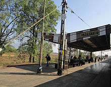
| Structure type | Standard on ground station |
| Parking | Yes |
| Bicycle facilities | No |
| Other information | |
| Status | Functioning |
| Station code | PNME |
| Division(s) | Dhanbad |
| History | |
| Opened | 1906 |
| Electrified | 1961-62 |
| Previous names | East Indian Railway |
| Location | |
 Parashnath railway station Location in Jharkhand | |
Dhanbad–Koderma line | |||||||||||||||||||||||||||||||||||||||||||||||||||||||||||||||||||||||||||||||||||||||||||||||||||||||||||||||||||||||||||||||||||||||||||||||||||||||||||||||||||||||||||||||||||||||||||||||||||||||||||||||||||||||||||||||||||||||||||||||||||||||||||||||||||||||||||||||||||||||||||||||||||||||||||||||||||||||||||||||||||||||||||||||||||||||||||||||||||||||||||||||||||||||||||||||||
|---|---|---|---|---|---|---|---|---|---|---|---|---|---|---|---|---|---|---|---|---|---|---|---|---|---|---|---|---|---|---|---|---|---|---|---|---|---|---|---|---|---|---|---|---|---|---|---|---|---|---|---|---|---|---|---|---|---|---|---|---|---|---|---|---|---|---|---|---|---|---|---|---|---|---|---|---|---|---|---|---|---|---|---|---|---|---|---|---|---|---|---|---|---|---|---|---|---|---|---|---|---|---|---|---|---|---|---|---|---|---|---|---|---|---|---|---|---|---|---|---|---|---|---|---|---|---|---|---|---|---|---|---|---|---|---|---|---|---|---|---|---|---|---|---|---|---|---|---|---|---|---|---|---|---|---|---|---|---|---|---|---|---|---|---|---|---|---|---|---|---|---|---|---|---|---|---|---|---|---|---|---|---|---|---|---|---|---|---|---|---|---|---|---|---|---|---|---|---|---|---|---|---|---|---|---|---|---|---|---|---|---|---|---|---|---|---|---|---|---|---|---|---|---|---|---|---|---|---|---|---|---|---|---|---|---|---|---|---|---|---|---|---|---|---|---|---|---|---|---|---|---|---|---|---|---|---|---|---|---|---|---|---|---|---|---|---|---|---|---|---|---|---|---|---|---|---|---|---|---|---|---|---|---|---|---|---|---|---|---|---|---|---|---|---|---|---|---|---|---|---|---|---|---|---|---|---|---|---|---|---|---|---|---|---|---|---|---|---|---|---|---|---|---|---|---|---|---|---|---|---|---|---|---|---|---|---|---|---|---|---|---|---|---|---|---|---|---|---|---|---|---|---|---|---|---|---|---|---|---|---|---|---|---|---|---|---|---|---|---|---|---|---|---|---|---|---|---|---|---|---|---|---|---|---|---|
| |||||||||||||||||||||||||||||||||||||||||||||||||||||||||||||||||||||||||||||||||||||||||||||||||||||||||||||||||||||||||||||||||||||||||||||||||||||||||||||||||||||||||||||||||||||||||||||||||||||||||||||||||||||||||||||||||||||||||||||||||||||||||||||||||||||||||||||||||||||||||||||||||||||||||||||||||||||||||||||||||||||||||||||||||||||||||||||||||||||||||||||||||||||||||||||||||
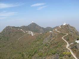
Parasnath railway station is on the Asansol-Gaya section of the Grand Chord and serves the town of Isri in Giridih district in the Indian state of Jharkhand. The Parasnath Hill or Shikharji, located nearby, with a height of 1,365 m (4,478 ft) is the highest mountain in the state of Jharkhand.
Etymology
The word Parasnath comes from the 23rd Tirthankara of Jainism, Parshva. Jains refer to the Parasnath Hill as Shikharji, and it is one of the two most prominent Jain pilgrimage centers, the other being Shetrunjaya, in Gujarat.[1] According to Jain belief, twenty of the twenty-four Tirthankaras (teachers of the Jains) attained Moksha (Nirvana) from Shikharji.
History
The Grand Chord was opened in 1906.[2]
Electrification
The Gomoh-Koderma sector was electrified in 1961-62.[3]
Shikharji
It is a holy place to visit with innumerable temples, shrines and meditation halls in the midst of natural scenery and wildlife.[1]
There are two recognized routes to Parasnath Hill. The summit of Parasnath Hill can be reached either from the southern or the northern side.[1]
The southern approach is from Isri Bazaar or Nimiaghat, to the top. It is motorable for about 2 km (1.2 mi), the rest being a climb of 8 km (5.0 mi).[1]
The northern approach is a 13 km (8.1 mi) route from Madhuban on the Dumri-Giridih road. Madhuban is about 40 km (25 mi) from Giridih and about 10 km (6.2 mi) from Parasnath rail station/ Isri Bazaar/ Dumri, all on Grand Trunk Road (NH 2). Buses ply along this route from Dumri to Giridih and stop at Madhuban village. Hired cars or taxis are available at Isri Bazar, just outside the rail station. There are a number of Jain temples at Madhuban. There is a metalled trek route of 9 km (5.6 mi) to the summit, a major part of which is motorable.[1]
Both the Svetambaras and Digambaras have established Dharamshalas or Ashrams here to accommodate the pilgrims to this the first most holy place for travelers from all over the world.The main hill belongs to the Digambaras.
New line survey
Connecting Giridih Station with Parasnath Madhuban rail line is one of the new line surveys to be taken up during 2012-13.[4]
References
- 1 2 3 4 5 "Parashnath". Hindu Books. Retrieved 2012-11-10.
- ↑ "IR History – Part III (1900-1947)". IRFCA. Retrieved 23 April 2013.
- ↑ "History of Electrification". IRFCA. Retrieved 20 April 2013.
- ↑ "What is new in Railway Budget 2012-13". The Times of India. 14 March 2012. Retrieved 2012-11-10.
External links
|
| |
|
|
- Trains passing through Parasnath Station

| Preceding station | Indian Railways | Following station | ||
|---|---|---|---|---|
| East Central Railway zone | Choudhurybandh |