Püspökladány District
| Püspökladány District Püspökladányi járás | ||
|---|---|---|
| Districts of Hungary | ||
| ||
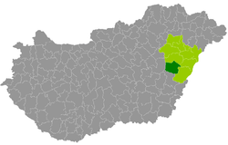 Püspökladány District within Hungary and Hajdú-Bihar County. | ||
| Country |
| |
| County | Hajdú-Bihar | |
| District seat | Püspökladány | |
| Area | ||
| • Total | 729.04 km2 (281.48 sq mi) | |
| Area rank | 4th in Hajdú-Bihar | |
| Population (2011 census) | ||
| • Total | 40,426 | |
| • Rank | 6th in Hajdú-Bihar | |
| • Density | 55/km2 (140/sq mi) | |

Püspökladány (Hungarian: Püspökladányi járás) is a district in south-western part of Hajdú-Bihar County. Püspökladány is also the name of the town where the district seat is found. The district is located in the Northern Great Plain Statistical Region. This district is a part of Hajdúság historical and geographical region.
Geography
Püspökladány District borders with Hajdúszoboszló District to the north, Derecske District and Berettyóújfalu District to the east, Szeghalom District (Békés County) to the south, Karcag District (Jász-Nagykun-Szolnok County) to the west. The number of the inhabited places in Püspökladány District is 12.
Municipalities
The district has 2 towns, 3 large villages and 7 villages. (ordered by population, as of 1 January 2012)[1]
- Báránd (2,530)
- Bihardancsháza (180)
- Biharnagybajom (2,731)
- Bihartorda (897)
- Földes (3,998)
- Kaba (5,932)
- Nagyrábé (1,974)
- Püspökladány (14,698) – district seat
- Sáp (938)
- Sárrétudvari (2,751)
- Szerep (1,506)
- Tetétlen (1,394)
The bolded municipalities are cities, italics municipalities are large villages.
Demographics
Religion in Püspökladány District (2011 census)
In 2011, it had a population of 40,426 and the population density was 55/km².
| Year | County population[2] | Change |
|---|---|---|
| 2011 | 40,426 | n/a |
Ethnicity
Besides the Hungarian majority, the main minority is the Roma (approx. 2,500).
Total population (2011 census): 40,426
Ethnic groups (2011 census):[3] Identified themselves: 37,778 persons:
- Hungarians: 35,227 (93.25%)
- Gypsies: 2,253 (5.96%)
- Others and indefinable: 298 (0.79%)
Approx. 3,000 persons in Püspökladány District did not declare their ethnic group at the 2011 census.
Religion
Religious adherence in the county according to 2011 census:[4]
- Reformed – 16,521;
- Catholic – 2,833 (Roman Catholic – 2,689; Greek Catholic – 142);
- other religions – 345;
- Non-religious – 11,462;
- Atheism – 227;
- Undeclared – 9,038.
Gallery
 Püspökladány, the district seat
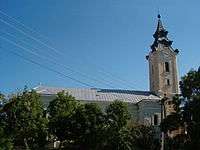 Reformed Church in Földes
_5.jpg) Traditional house from Biharnagybajom
Traditional house from Biharnagybajom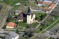 Aerial view of Püspökladány
See also
References
- ↑ A KSH 2012. évi helységnévkönyve
- ↑ népesség.com, "Püspökladányi járás népessége"
- ↑ 4.1.6.1 A népesség nemzetiség szerint, 2011, (in Hungarian)
- ↑ 4.1.7.1 A népesség vallás, felekezet szerint, 2011, (in Hungarian)
External links
| Towns (2) |
| |
|---|---|---|
| Large villages (3) | ||
| Villages (7) | ||
Coordinates: 47°19′00″N 21°13′00″E / 47.3167°N 21.2167°E