Tetétlen
| Tetétlen | ||
|---|---|---|
| ||
| Country |
| |
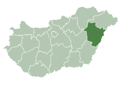
| County | Hajdú-Bihar | |
| Area | ||
| • Total | 32.11 km2 (12.40 sq mi) | |
| Population (2001) | ||
| • Total | 1,455 | |
| • Density | 45.31/km2 (117.4/sq mi) | |
| Time zone | UTC+1 (CET) | |
| • Summer (DST) | UTC+2 (CEST) | |
| Postal code | 4184 | |
| Area code(s) | 54 | |

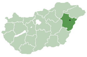
Location of Hajdú-Bihar county in Hungary
Tetétlen is a village in Hajdú-Bihar county, in the Northern Great Plain region of eastern Hungary.
Geography
It covers an area of 32.11 km2 (12 sq mi) and has a population of 1455 people (2001).
| City with county rights |
|   |
|---|---|---|
| Towns | ||
| Large villages | ||
| Villages |
| |
| Other topics |
| |
Coordinates: 47°18′58″N 21°18′19″E / 47.31606°N 21.30517°E
This article is issued from
Wikipedia.
The text is licensed under Creative Commons - Attribution - Sharealike.
Additional terms may apply for the media files.