Berettyóújfalu District
| Berettyóújfalu District Berettyóújfalui járás | ||
|---|---|---|
| Districts of Hungary | ||
| ||
 Berettyóújfalu District within Hungary and Hajdú-Bihar County. | ||
| Country |
| |
| County | Hajdú-Bihar | |
| District seat | Berettyóújfalu | |
| Area | ||
| • Total | 1,073.90 km2 (414.64 sq mi) | |
| Area rank | 1st in Hajdú-Bihar | |
| Population (2011 census) | ||
| • Total | 44,995 | |
| • Rank | 2nd in Hajdú-Bihar | |
| • Density | 42/km2 (110/sq mi) | |

Berettyóújfalu (Hungarian: Berettyóújfalui járás) is a district in south-eastern part of Hajdú-Bihar County. Berettyóújfalu is also the name of the town where the district seat is found. The district is located in the Northern Great Plain Statistical Region. This district is a part of Bihar historical and geographical region.
Geography
Berettyóújfalu District borders with Derecske District to the north, the Romanian county of Bihor to the east, Sarkad District (Békés County) to the south, Szeghalom District (Békés County) and Püspökladány District to the west. The number of the inhabited places in Berettyóújfalu District is 25.
Municipalities
The district has 3 towns, 2 large villages and 20 villages. (ordered by population, as of 1 January 2012)[1]
- Ártánd (502)
- Bakonszeg (1,160)
- Bedő (252)
- Berekböszörmény (1,749)
- Berettyóújfalu (15,167) – district seat
- Biharkeresztes (4,149)
- Bojt (489)
- Csökmő (1,756)
- Darvas (527)
- Furta (1,136)
- Gáborján (876)
- Hencida (1,275)
- Komádi (5,172)
- Körösszakál (814)
- Körösszegapáti (882)
- Magyarhomorog (868)
- Mezőpeterd (533)
- Mezősas (591)
- Nagykereki (1,205)
- Szentpéterszeg (1,101)
- Told (310)
- Újiráz (505)
- Váncsod (1,221)
- Vekerd (112)
- Zsáka (1,544)
The bolded municipalities are cities, italics municipalities are large villages.
Demographics
Religion in Berettyóújfalu District (2011 census)
In 2011, it had a population of 44,995 and the population density was 36/km².
| Year | County population[2] | Change |
|---|---|---|
| 2011 | 44,995 | n/a |
Ethnicity
Besides the Hungarian majority, the main minorities are the Roma (approx. 3,000), Romanian (1,000) and German (200).
Total population (2011 census): 44,995
Ethnic groups (2011 census):[3] Identified themselves: 42,143 persons:
- Hungarians: 38,009 (90.19%)
- Gypsies: 2,694 (6.39%)
- Romanians: 1,111 (2.64%)
- Others and indefinable: 329 (0.78%)
Approx. 3,000 persons in Berettyóújfalu District did not declare their ethnic group at the 2011 census.
Religion
Religious adherence in the county according to 2011 census:[4]
- Reformed – 19,399;
- Catholic – 3,480 (Roman Catholic – 2,996; Greek Catholic – 484);
- Orthodox – 618;
- Evangelical – 86;
- other religions – 675;
- Non-religious – 9,703;
- Atheism – 262;
- Undeclared – 10,772.
Gallery
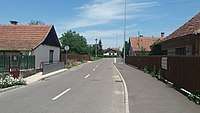 Berettyóújfalu, the district seat
.jpg) Rédely Mansion in Zsáka
Rédely Mansion in Zsáka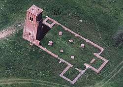 Csonkatorony from above (Herpály)
 Reformed Church in Biharkeresztes
See also
References
- ↑ A KSH 2012. évi helységnévkönyve
- ↑ népesség.com, "Berettyóújfalui járás népessége"
- ↑ 4.1.6.1 A népesség nemzetiség szerint, 2011, (in Hungarian)
- ↑ 4.1.7.1 A népesség vallás, felekezet szerint, 2011, (in Hungarian)
External links
| Towns (3) |
| |
|---|---|---|
| Large villages (2) | ||
| Villages (20) | ||