Oxford, Alabama
| Oxford, Alabama | ||
|---|---|---|
| City | ||
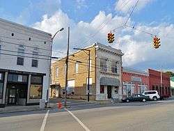 Downtown Oxford | ||
| ||
| Nickname(s): Crossroads to the Future | ||
 Location of Oxford in Calhoun County and Talladega County, Alabama. | ||
| Coordinates: 33°35′49″N 85°50′19″W / 33.59694°N 85.83861°WCoordinates: 33°35′49″N 85°50′19″W / 33.59694°N 85.83861°W | ||
| Country | United States | |
| State | Alabama | |
| Counties | Calhoun, Talladega | |
| Government | ||
| • Mayor | Alton Craft | |
| Area[1] | ||
| • Total | 32.11 sq mi (83.16 km2) | |
| • Land | 31.76 sq mi (82.26 km2) | |
| • Water | 0.35 sq mi (0.90 km2) | |
| Elevation | 653 ft (199 m) | |
| Population (2010) | ||
| • Total | 21,348 | |
| • Estimate (2017)[2] | 21,180 | |
| • Density | 666.88/sq mi (257.48/km2) | |
| Time zone | UTC-6 (Central) | |
| • Summer (DST) | UTC-5 (Central) | |
| ZIP code | 36203 | |
| Area code(s) | 256/938 | |
| FIPS code | 01-57576 | |
| GNIS feature ID | 0160330 | |
| Website |
www | |

Oxford is a city in Calhoun and Talladega counties in the State of Alabama. The population was 21,348 at the 2010 census,[3] an increase of 46.3% since the 2000 Census. Oxford is one of two principal cities of and included in the Anniston-Oxford Metropolitan Statistical Area.
History
Founded in the early 1850s, Oxford was the first city in Calhoun County to be incorporated, in 1852.[4] The name "Oxford" was due to the presence of a narrow crossing of Chocolocco Creek that allowed farmers to ford cattle from one side of the creek to the other. Since 1970, Oxford has annexed large amounts of land to the south and west, including the communities of Coldwater and Bynum. In 1970, it was all in Calhoun County, but today it includes areas in Talladega County.[5]
A smaller municipality, Hobson City, was once a part of Oxford. The area, then known as the Mooree Quarter, is one square mile, and is located north and west of Oxford, and south and west of Anniston. In the last years of the 19th century, according to tradition, in the course of political elections, a black man managed to be elected justice of the peace in Oxford. This being unacceptable to the city fathers, they appealed to the powers in the state capital, and an 'arrangement' was made. The city boundaries were redrawn, in similar fashion to a gerrymander, and the quarter was excluded, becoming a town unto itself. The new town became incorporated on August 16, 1899 as Hobson City, taking the name of a naval hero of the Spanish–American War.[6] The intention was that the largely black population of this quarter would no longer skew the elections of the now almost exclusively white Oxford. Another result was the creation of only the second town in the United States (after Eatonville, Florida) with 100% black government, and an almost 100% black population (at least at first).[7]
Geography
According to the U.S. Census Bureau, the city has a total area of 31.0 square miles (80.3 km2), of which 30.7 square miles (79.4 km2) is land and 0.35 square miles (0.9 km2), or 1.07%, is water.[3]
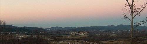
Oxford lies among the foothills at the southern end of the Blue Ridge Mountains. Nearby Cheaha Mountain is Alabama's highest point and offers expansive views of the surrounding wilderness and the city below. Much of the city's southern border is shared with the Talladega National Forest.
Major bodies of water include Oxford Lake, Lake Hillabee, Snows Creek and Choccolocco Creek, which bisects the city.
Demographics
| Historical population | |||
|---|---|---|---|
| Census | Pop. | %± | |
| 1880 | 780 | — | |
| 1890 | 1,473 | 88.8% | |
| 1900 | 1,372 | −6.9% | |
| 1910 | 1,090 | −20.6% | |
| 1920 | 1,108 | 1.7% | |
| 1930 | 1,206 | 8.8% | |
| 1940 | 1,393 | 15.5% | |
| 1950 | 1,697 | 21.8% | |
| 1960 | 3,603 | 112.3% | |
| 1970 | 4,361 | 21.0% | |
| 1980 | 8,939 | 105.0% | |
| 1990 | 9,362 | 4.7% | |
| 2000 | 14,592 | 55.9% | |
| 2010 | 21,348 | 46.3% | |
| Est. 2017 | 21,180 | [2] | −0.8% |
| U.S. Decennial Census[8] 2013 Estimate[9] | |||
As of the census of 2010, there were 21,348 people, 8,072 households, and 5,955 families residing in the city. The population density was 688 people per square mile (265.9/km²). There were 8,806 housing units at an average density of 284 per square mile (109.6/km²). The racial makeup of the city was 80.5% White, 12.6% Black or African American, 0.4% Native American, 1.1% Asian, 0.0% Pacific Islander, 3.9% from other races, and 1.5% from two or more races. 6.6% of the population were Hispanic or Latino of any race.
There were 8,072 households out of which 32.2% had children under the age of 18 living with them, 55.4% are married couples living together, 13.9% had a female householder with no husband present, and 26.2% were non-families. 22.6% of all households were made up of individuals and 9.2% had someone living alone who was 65 years of age or older. The average household size was 2.61 and the average family size was 3.05.
In the city, the population was spread out with 25.2% under the age of 18, 8.0% from 18 to 24, 26.8% from 25 to 44, 26.7% from 45 to 64, and 13.3% who were 65 years of age or older. The median age was 37.8 years. For every 100 females, there were 93.0 males. For every 100 females age 18 and over, there were 96.0 males.
The median income for a household in the city was $47,928, and the median income for a family was $53,612. Males had a median income of $46,008 versus $30,231 for females. The per capita income for the city was $22,815. About 10.8% of families and 13.4% of the population were below the poverty line, including 22.3% of those under age 18 and 7.4% of those age 65 or over.
Economy
The city's growth in recent years can be attributed mainly to the presence of Interstate 20 and Oxford's central location between Atlanta and Birmingham. The Quintard Mall is the only fully enclosed shopping mall between Birmingham and Douglasville, Georgia. Several other shopping centers dot the landscape of Oxford with the most recent being the construction of the Oxford Commons which is just off exit 188 on Interstate 20.
Arts and culture

- The Southern Preppers Expo (every September)[10]
- Quintard Mall
- Oxford Lake Park
- Choccolocco Park[11]
Government
Oxford features a mayor-council form of government, though the mayor actually dictates the daily running of the city. Alton Craft is the current mayor, having succeeded former Mayor Leon Smith, whose mayorship began in 1984 and retired from office after his eighth term. Craft previously served as the Finance Director of Oxford for over two decades. The five-member council includes Phil Gardner (Place 1), Charlotte Hubbard (Place 2), Mike Henderson (Place 3), Chris Spurlin (Place 4, Council President), and Steven Waits (Place 5). The mayor and city council members are elected to four-year terms (coinciding with presidential election years).
Education
Oxford's public schools are administered by the Oxford City School System. There are four elementary schools, one middle school, and one high school. A new Freshman Academy building, for the ninth grade of Oxford High School, opened in January 2009. A new Oxford High School building opened in August 2010, as well as a new Technical Building to be finished by the end of 2014.[12]
Oxford High School has an approximate enrollment of 1,002 students and is classified as a Class 6A school.
Media
- WTBJ-FM 91.3 (Christian Radio)
- WTDR-FM 92.7 (Country)
- WVOK-FM 97.9 (Adult Contemporary)
- WVOK-AM 1580 (Oldies)
- WEAC-TV24 (Television Broadcast Station)
- The Anniston Star (25,000 circulation daily newspaper)
- Oxford Independent (weekly newspaper)
- Insight (a bi-monthly entertainment and event paper serving Oxford and Calhoun county)
Infrastructure
Transportation
Major highways passing through Oxford include:
.svg.png)


Law enforcement
The city maintains a sixty-man police department. The agency is divided into Uniform Division, Criminal Investigation Division, Administrative Division. The agency also has several specialized units including Special Investigations Division, Emergency Services Unit, Traffic Homicide Unit, Aviation Unit, and Honor Guard.[13]
Notable people
- Kwon Alexander, NFL, Tampa Bay Buccaneers
- Trae Elston, NFL, Miami Dolphins
- The Bridges, folk rock band
- Rick Burgess, half of the nationally syndicated radio program Rick and Bubba
- Asa Earl Carter, Ku Klux Klan leader, segregationist speech writer, and later famed western novelist
- Chris Hammond, former Major League Baseball pitcher
- Terry Henley, former Auburn University and National Football League running back
- Maud McLure Kelly, first woman lawyer in Alabama
- Lash LeRoux, cartoonist and former professional wrestler
- Bobby McCain, NFL, Miami Dolphins
- Jim Stephens, former Major League Baseball catcher
References
- ↑ "2017 U.S. Gazetteer Files". United States Census Bureau. Retrieved Jul 7, 2018.
- 1 2 "Population and Housing Unit Estimates". Retrieved March 24, 2018.
- 1 2 "Geographic Identifiers: 2010 Demographic Profile Data (G001): Oxford city, Alabama". U.S. Census Bureau, American Factfinder. Retrieved June 2, 2014.
- ↑ Alabama Encyclopedia
- ↑ Old borders based on Andriot, John L. Township Atlas of the United States (McLean, Virginia: Andriot Associates, 1979) p. 17
- ↑ Claire M. Wilson, of Auburn University, Alabama Encyclopedia, retrieved 5Dec2014
- ↑ The Story of the Progress and Achievements of the Negro in the Art of Self Government, by Ross Blackmon, published in 1947
- ↑ United States Census Bureau. "Census of Population and Housing". Retrieved November 20, 2013.
- ↑ "Annual Estimates of the Resident Population: April 1, 2010 to July 1, 2013". Retrieved June 7, 2014.
- ↑ http://www.thesouthernpreppers.com
- ↑ http://www.choccoloccopark.com/
- ↑ http://www.oxford.k12.al.us Oxford City Schools
- ↑ http://www.oxfordpd.org
External links
Municipalities and communities of Calhoun County, Alabama, United States | ||
|---|---|---|
| Cities | 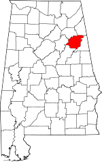 | |
| Towns | ||
| CDPs | ||
| Unincorporated communities | ||
| Ghost town | ||
| Footnotes | ‡This populated place also has portions in an adjacent county or counties | |
Municipalities and communities of Talladega County, Alabama, United States | ||
|---|---|---|
| Cities | 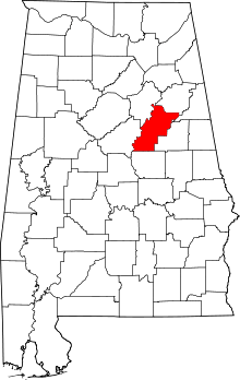 | |
| Towns | ||
| CDPs | ||
| Unincorporated communities | ||
| Ghost town | ||
| Footnotes | ‡This populated place also has portions in an adjacent county or counties | |