Tooktocaugee, Alabama
| Tooktocaugee, Alabama | |
|---|---|
| Unincorporated community | |
 Tooktocaugee, Alabama  Tooktocaugee, Alabama | |
| Coordinates: 33°41′35″N 85°41′55″W / 33.69306°N 85.69861°W | |
| Country | United States |
| State | Alabama |
| County | Calhoun |
| Elevation | 696 ft (212 m) |
| Time zone | UTC-6 (Central (CST)) |
| • Summer (DST) | UTC-5 (CDT) |
| GNIS feature ID | 162881[1] |
Tooktocaugee was an unincorporated community in Calhoun County, Alabama, United States. Tooktocaugee was formerly the site of a Creek Indian village.[2]
References
- ↑ "Tooktocaugee". Geographic Names Information System. United States Geological Survey.
- ↑ "Indian Villages and Forts of the Coosa-Tallapoosa River Region" (PDF). University of Alabama. Retrieved 29 December 2014.
Municipalities and communities of Calhoun County, Alabama, United States | ||
|---|---|---|
| Cities | 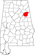 | |
| Towns | ||
| CDPs | ||
| Unincorporated communities | ||
| Ghost town | ||
| Footnotes | ‡This populated place also has portions in an adjacent county or counties | |
This article is issued from
Wikipedia.
The text is licensed under Creative Commons - Attribution - Sharealike.
Additional terms may apply for the media files.