Nances Creek, Alabama
| Nances Creek, Alabama | |
|---|---|
| Census-designated place | |
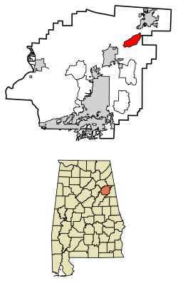 Location of Nances Creek in Calhoun County, Alabama. | |
 Nances Creek Location of Nances Creek in Calhoun County, Alabama. | |
| Coordinates: 33°51′28″N 85°39′25″W / 33.85778°N 85.65694°WCoordinates: 33°51′28″N 85°39′25″W / 33.85778°N 85.65694°W | |
| Country | United States |
| State | Alabama |
| County | Calhoun |
| Area[1] | |
| • Total | 5.82 sq mi (15.06 km2) |
| • Land | 5.81 sq mi (15.04 km2) |
| • Water | 0.01 sq mi (0.02 km2) |
| Elevation | 761 ft (232 m) |
| Population (2010)[2] | |
| • Total | 130 |
| • Estimate (2016)[3] | N/A |
| Time zone | UTC-6 (Central (CST)) |
| • Summer (DST) | UTC-5 (CDT) |
| Area code(s) | 256 & 938 |
| GNIS feature ID | 160210[4] |
Nances Creek is a census-designated place and unincorporated community in Calhoun County, Alabama, United States. Its population was 407 as of the 2010 census.[5]
Demographics
| Historical population | |||
|---|---|---|---|
| Census | Pop. | %± | |
| U.S. Decennial Census[6] | |||
References
- ↑ "2016 U.S. Gazetteer Files". United States Census Bureau. Retrieved Jul 17, 2017.
- ↑ "American FactFinder". United States Census Bureau. Retrieved 2011-05-14.
- ↑ "Population and Housing Unit Estimates". Retrieved June 9, 2017.
- ↑ "Nances Creek". Geographic Names Information System. United States Geological Survey.
- ↑ "Geographic Identifiers: 2010 Demographic Profile Data (G001): Nances Creek CDP, Alabama". U.S. Census Bureau, American Factfinder. Retrieved June 2, 2014.
- ↑ "Census of Population and Housing". Census.gov. Retrieved June 4, 2016.
Municipalities and communities of Calhoun County, Alabama, United States | ||
|---|---|---|
| Cities | 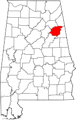 | |
| Towns | ||
| CDPs | ||
| Unincorporated communities | ||
| Ghost town | ||
| Footnotes | ‡This populated place also has portions in an adjacent county or counties | |
This article is issued from
Wikipedia.
The text is licensed under Creative Commons - Attribution - Sharealike.
Additional terms may apply for the media files.