Ōtaki, Chiba
| Ōtaki 大多喜町 | |||
|---|---|---|---|
| Town | |||
 | |||
| |||
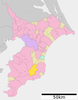 Location of Ōtaki in Chiba Prefecture | |||
 Ōtaki | |||
| Coordinates: 35°17′6.6″N 140°14′43.5″E / 35.285167°N 140.245417°ECoordinates: 35°17′6.6″N 140°14′43.5″E / 35.285167°N 140.245417°E | |||
| Country |
| ||
| Region | Kantō | ||
| Prefecture | Chiba Prefecture | ||
| District | Isumi District | ||
| Area | |||
| • Total | 129.87 km2 (50.14 sq mi) | ||
| Population (December 1, 2015) | |||
| • Total | 9,676 | ||
| • Density | 74.5/km2 (193/sq mi) | ||
| Time zone | UTC+9 (Japan Standard Time) | ||
| - Tree | Sakura | ||
| Phone number | 0470-82-2111 | ||
| Address | 93 Ōtaki, Ōtaki-machi, Chiba-ken 298-0292 | ||
| Website | http://www.town.otaki.chiba.jp/ | ||

Ōtaki (大多喜町 Ōtaki-machi) is a town located in Chiba Prefecture, Japan. The town is known for its association with Edo period general Honda Tadakatsu, and its prominent castle. As of December 2015, the town had an estimated population of 9,676, and a population density of 74.5 persons per km2. The total area the town is 129.87 square kilometres (50.14 sq mi), making it the largest of Chiba Prefecture's towns and villages.
Etymology
The name of the town of Ōtaki in the Japanese language is composed of three kanji characters: the first, ō (大), meaning "large", the second, ta (多), meaning "many", and the third, ki (喜), meaning "happiness".
Geography
Ōtaki is a landlocked town in the center of the Bōsō Peninsula. The southwest area of Otaki is mountainous, with altitudes gradually lowering towards the northeast of the town. 70% of Ōtaki is covered by forest. The Isumi River flows through the town to the northeast, and in the western part of the town the Yōrō River flows to the north.
Surrounding municipalities
Chiba Prefecture
History
Early history
Ōtaki was settled in prehistoric times, as evidenced by the Jōmon period remains in Oikawa. In the Asuka period the Ōtaki region became part of Kazusa Province at the western end of the Tōkaidō region, which was formed as a result of the Taika Reform of 654. In the Sengoku period Ōtaki was established as a castle town, which successively controlled by different regional clans, most notably the Takeda clan and the Toki clan. The Ōtaki region ultimately came under the control of the powerful Awa Province-based Satomi clan in 1544.
Edo Period
In 1590 Tokugawa Ieyasu took control of all of Kazusa Province. Ieyasu granted Ōtaki to his famed general Honda Tadakatsu, and established the Ōtaki Domain as a 100,000 koku feudal domain. Tadakatsu built Ōtaki Castle on the site of the earlier castle and laid out a large-scale castle town. Honda Tadakatsu's placement at Ōtaki was a strong buffer against the military power of the Satomi clan to the south. The ownership of the castle changed hands many times after Honda Tadakatsu's control, but from 1703 the Matsudaira clan held the castle for nine generations. Despite the Matsudaira clan's control of the castle, the majority of the Ōtaki region was controlled as tenryō territory by hatamoto in direct service to the Tokugawa shogunate. In 1609 a Spanish galleon, the San Francisco, ran aground near Ōtaki . The survivors were housed in Ōtaki Castle, and later, the sailors were given a ship by the shogunate to return to Mexico. One of the survivors was Governor General of the Philippines Rodrigo de Vivero, who was subsequently granted an audience with shōgun Tokugawa Ieyasu.[1]
Modern Period
After the Meiji Restoration the administrative structure of the region changed frequently. Ōtaki was successively part of Ōtaki Prefecture, then Kisarazu Prefecture, before becoming part of the present-day Chiba Prefecture. In 1889, under the same administrative reforms, the four villages of Oikawa, Nishihata, Fusamoto, Kamitaki and the town of Ōtaki were formed. The five were brought together to become present-day town of Ōtaki on October 5, 1954.

Economy
The economy of Ōtaki was based largely on rice production, forestry, and traditional charcoal production, but after World War II all three industries have declined. The town produces shiitake mushrooms and bamboo shoots as special agricultural products. Tourism has increased as a result of visits to Ōtaki Castle, the Ōtaki Prefectural Forest, and various scenic spots. Golf courses were developed in Ōtaki, but have caused problems with flooding and deforestation.[2]
Transportation
Railways
- Isumi Railway - Isumi Line
- Shiromigaoka - Ōtaki - Koyamatsu - Higashi-Fusamoto - Kugahara - Fusamoto - Nishihata - Kazusa-Nakano
- Kominato Railway - Kominato Line
Roads and highways
- Japan National Route 297, to Ichihara or Tateyama
- Japan National Route 465, to Mobara or Futtsu
- Prefectural Route 27, Mobara-Ōtaki
- Prefectural Route 32, Ōtaki-Kimitsu
- Prefectural Route 81, Ichihara-Amatsukominato
- Prefectural Route 150, Ōtaki-Ichinomiya
- Prefectural Route 172, Ōtaki-Ichihara Satomi
- Prefectural Route 177, Katsuura-Ōtaki
- Prefectural Route 178, Ōtaki Odashiro-Katsuura
- Prefectural Route 231, Isumi Railroad Ōtaki Station-Ōtaki Koyamatsu
Local attractions
Castle Festival
Ōtaki hosts the Oshiro-matsuri, or castle festival, in September, which involves a parade and various plays and demonstrations on the grounds of one of the town's elementary schools. Representatives from Ōtaki's sister city, Cuernavaca, Mexico, often visit to attend the festival.
List of attractions
- Ōtaki Castle, built in 1521 and demolished in 1871. While the stone base of the current structure is the base of the original castle's donjon, the present building is a reproduction of the original castle tower. It houses the Ōtaki Branch of the Chiba Prefectural Museum.
- Herb Island
- Ōtaki Prefectural Forest
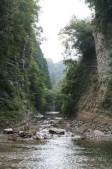
- Yōrō Ravine
- Awamata Waterfall
- Ryōgen-ji
- Myōhōshō-ji
- Watanabe Historical Residence
- Central Bōsō Railroad Center
Education and community centers
Universities
- Saniku Gakuin College
- Saniku Gakuin Junior College
High schools
- Ōtaki Prefectural High School
Junior high schools
- Ōtaki Junior High School
- West Ōtaki Junior High School
Elementary schools
- Oikawa Elementary School
- Nishihata Elementary School
- Fusamoto Elementary School
- Ōtaki Elementary School
- Kamitaki Elementary School
Community institutions
- Ōtaki Central Community Center
- Ōtaki Public Library
- Marine Center
- Ōtaki Sports Park
- Ōtaki Elderly Welfare Center
- Ōtaki Elderly Nursing Home
Sister city relations

References
- ↑ The Ministry of Foreign Affairs of Japan (2010) Japan-Mexico Relations
- ↑ "Ōtaki-machi". Nihon Rekishi Chimei Taikei (日本歴史地名大系 “Compendium of Japanese Historical Place Names”). Tokyo: Netto Adobansusha. 2011. Retrieved 2011-11-18.
- ↑ "International Exchange". List of Affiliation Partners within Prefectures. Council of Local Authorities for International Relations (CLAIR). Retrieved 21 November 2015.
| Wikimedia Commons has media related to Otaki, Chiba. |
External links
- Official Website (in Japanese)
| Wards of Chiba | ||
|---|---|---|
| Core cities | ||
| Cities | ||
| Districts | ||