Valfurva
| Valfurva | |
|---|---|
| Comune | |
| Comune di Valfurva | |
 The Tresero in October 2005. | |
 Valfurva Location of Valfurva in Italy | |
| Coordinates: 46°27′N 10°25′E / 46.450°N 10.417°ECoordinates: 46°27′N 10°25′E / 46.450°N 10.417°E | |
| Country | Italy |
| Region | Lombardy |
| Province | Province of Sondrio (SO) |
| Frazioni | Uzza, San Nicolò, Sant'Antonio, San Gottardo, Madonna dei Monti, Santa Caterina |
| Government | |
| • Mayor | Confortola Fabio |
| Area | |
| • Total | 215.9 km2 (83.4 sq mi) |
| Elevation | 1,800 m (5,900 ft) |
| Population (Dec. 2004) | |
| • Total | 2,725 |
| • Density | 13/km2 (33/sq mi) |
| Time zone | UTC+1 (CET) |
| • Summer (DST) | UTC+2 (CEST) |
| Postal code | 23030 |
| Dialing code | 0342 |
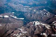
View of Bormio and Valfurva at 10,000m
Valfurva is a comune (municipality) in the Province of Sondrio in the Italian region Lombardy, located about 150 kilometres (93 mi) northeast of Milan and about 50 kilometres (31 mi) northeast of Sondrio, in the Alps. As of 31 December 2004, it had a population of 2,725 and an area of 215.9 square kilometres (83.4 sq mi).[1]
The municipality of Valfurva contains the frazioni (subdivisions, mainly villages and hamlets) Uzza, San Nicolò, Sant'Antonio, San Gottardo, Madonna dei Monti, and Santa Caterina.
Valfurva borders the following municipalities: Bormio, Martell, Peio, Ponte di Legno, Sondalo, Stilfs, Valdisotto.
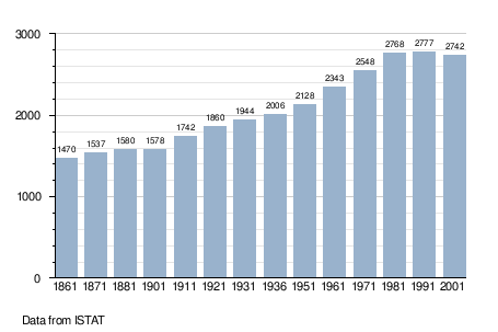
Demographic evolution
References

This article is issued from
Wikipedia.
The text is licensed under Creative Commons - Attribution - Sharealike.
Additional terms may apply for the media files.