Orange River
| Orange | |
| Gariep, Oranje, Senqu | |
| River | |
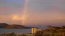
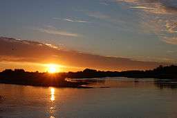 Sunset over the Orange River near Upington in the Northern Cape | |
| Countries | Lesotho, South Africa, Namibia |
|---|---|
| Tributaries | |
| - right | Caledon River, Vaal River, Fish River (Namibia) |
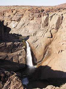
| Landmarks | Gariep Dam, Augrabies Falls |
| Source | Thaba Putsoa [1] |
| - location | Maloti Mountains (Drakensberg), Lesotho |
| - elevation | 3,350 m (10,991 ft) |
| Mouth | Alexander Bay |
| - location | Atlantic Ocean |
| Length | 2,200 km (1,367 mi) |
| Basin | 973,000 km2 (375,677 sq mi) |
| Discharge | |
| - average | 365 m3/s (12,890 cu ft/s) |
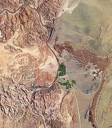
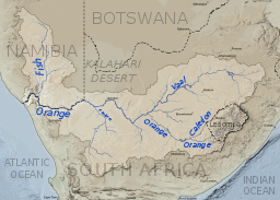 The course and watershed of the Orange River, Caledon River and Vaal River. This map shows a conservative border for the watershed. Specifically, the Kalahari basin is excluded, as some sources say it is endorheic.[2] Some other sources using computational methods show a basin which includes parts of Botswana (and hence of the Kalahari).[3] | |
| Designations | |
|---|---|
| Official name | Orange River Mouth (Namibia) |
| Designated | 23 August 1995 |
| Reference no. | 744[4] |
| Official name | Orange River Mouth (South Africa) |
| Designated | 28 June 1991 |
| Reference no. | 526[5] |
The Orange River (from Afrikaans/Dutch: Oranjerivier) is the longest river in South Africa and the Orange River Basin extends extensively into Namibia and Botswana to the north. It rises in the Drakensberg mountains in Lesotho, flowing westwards through South Africa to the Atlantic Ocean. The river forms part of the international borders between South Africa and Namibia and between South Africa and Lesotho, as well as several provincial borders within South Africa. Except for Upington, it does not pass through any major cities. The Orange River plays an important role in the South African economy by providing water for irrigation and hydroelectric power. The river was named by Robert Jacob Gordon after the Dutch Royal House. Other names include Gariep River (used by the Khoi people[6]), Groote River or Senqu River (used in Lesotho).[7]
Course
The Orange rises in the Drakensberg mountains along the border between South Africa and Lesotho, about 193 km (120 mi) west of the Indian Ocean and at an altitude of over 3,000 m. The extremity of the Orange River inside Lesotho is known as the Senqu. Parts of the Senqu River freeze in winter because of the high altitude there. This creates droughts downstream, which mainly affect goat and cattle production.
The Orange River then runs westward through South Africa, forming the south-western boundary of the Free State province. In this section, the river flows first into the Gariep Dam (the largest in the country), and later into the Vanderkloof Dam. From the border of Lesotho to below the Van der Kloof Dam, the river bed is deeply incised. Further downstream, the land is flatter, and the river is used extensively for irrigation.
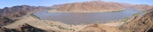
At the western point of the Free State, southwest of Kimberley, the Orange meets with its main tributary, the Vaal River, which itself forms much of the northern border of the province. From here, the river flows further westward through the arid wilderness of the southern Kalahari region and Namaqualand in the Northern Cape Province to meet with Namibia at 20°E longitude. From here, it flows westward for 550 km,[8] forming the international border between the province and Namibia's ǁKaras Region. On the border, the river passes the town of Vioolsdrif, the main border post between South Africa and Namibia.
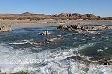
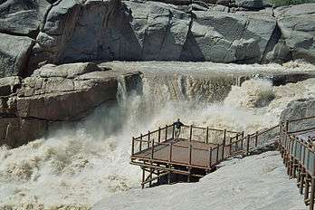
In the last 800 km (500 mi) of its course, the Orange receives many intermittent streams, and several large wadis lead into it. In this section, the Namib Desert terminates on the north bank of the river, so under normal circumstances, the volume of water added by these tributaries is negligible. Here, the bed of the river is once again deeply incised. The Augrabies Falls are located on this section of the Orange, where the river descends 122 m (400 ft) in a course of 26 km (16 mi).
The Orange empties into the Atlantic Ocean between the small towns of Oranjemund (meaning "Orange mouth") in Namibia and Alexander Bay in South Africa, about equidistant between Walvis Bay and Cape Town. Some 33 km (21 mi) from its mouth, it is completely obstructed by rapids and sand bars and is generally not navigable for long stretches.
The river has a total length of 2,200 km (1,400 mi).
Catchment and rainfall
In the dry winter, the volume of the water in the river is considerably reduced because of the rapid run-off and evaporation. At the source of the Orange, the rainfall is about 2,000 mm per annum, but precipitation decreases as the river flows westward; at its mouth, the rainfall is less than 50 mm per year. The factors that support evaporation, though, tend to increase in a westerly direction. In the wet season (summer), the Orange river becomes an impetuous, brown torrent. The huge mass of sediment carried constitutes a long-term threat to all engineering projects on the river.[9]
The total catchment of the Orange River (including the Vaal) extends over 973,000 km², i.e. equivalent to about 77% of the land area of South Africa (1,268,5358 km²). Around 366,000 km² (38%), however, are situated outside the country in Lesotho, Botswana, and Namibia.
History
Name of the river
The earliest precolonial inhabitants called the river Gariep'.[8] An early Dutch name for the river was Groote Rivier meaning "Great River". [10] The river was named the Orange River by Colonel Robert Gordon, commander of the Dutch East India Company garrison at Cape Town, on a trip to the interior in 1779.[8] Gordon named the river in honor of William V of Orange.[8] A popular but incorrect belief is that the river was named after the supposedly orange color of its water, as opposed to the color its tributary, the Vaal River (vaal being Afrikaans for pale or grey). Since the end of apartheid, the name "Gariep" has had greater favour in official correspondence in South Africa, although the name "Orange" has greater international recognition.[8] In Lesotho, where the river rises, it is known as the Senqu River.
Renaming the river
The Eastern Cape Geographical Names Committee has advertised its intention to consider a name change for that portion of the river that forms the border between the Eastern Cape and the Free State, with suggestions being IGqili or Senqu.[11][12] The advertisement placed in the Aliwal Weekblad newspaper states that the "present name is perceived to have a strong association with the history of colonial subjugation and has therefore no place under the current democratic dispensation."[12]
Economy
As the collection point for the majority of South Africa's water, the Orange River plays a major role in supporting agriculture, industry, and mining. To assist in this, two large water schemes have been created, the Orange River Project and the Lesotho Highlands Water Project. Historically, the river played an important role in the South African diamond rush, with the first diamonds in the country being discovered in alluvial deposits on the Orange. Today, several commercial diamond mines operate along the final stretch of the Orange River and around its mouth. Finally, because of the lack of dangerous animals and high water levels during summer, the river is used for recreational canoeing and rafting. Orange River rafting has become very popular with many companies using their camps along the river from which to operate. The most popular trips are four-day and six-day river trips that take place either along the gorge below the Augrabies Falls or along the Richtersveld area.
Orange River Project
The Orange River Project (ORP) was one of the largest and most imaginative projects of its kind in South Africa. It was constructed by Hendrik Verwoerd's government at the height of the apartheid era. The ORP was built to use the unused water of the Orange River — which, without the Vaal River, represents some 14.1% of the total runoff in South Africa — and in the process, to satisfy an increasing demand for water. The main objectives of the project were:
- to stabilise river flow,
- the generation and transmission of hydroelectric power,
- to provide a reliable water supply for users in the Orange River basin, and
- to give a new lease on life to water-deficient areas in the Eastern Cape, such as the Great Fish and Sundays River valleys.
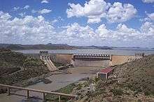
The Gariep Dam near Colesberg, named the Hendrik Verwoerd Dam when built, is the main storage structure within the Orange River. From here, the water is supplied in two directions, westward along the Orange River (via hydroelectric power generators) to the Vanderkloof Dam which was previously named the PK le Roux Dam, and southward through the Orange-Fish Tunnel to the Eastern Cape.
Hydroelectricity
Eskom operates hydroelectric power stations at both the Gariep Dam and the Vanderkloof Dam. The hydroelectric power station at the Vanderkloof Dam was the first power-generation station in South Africa situated entirely underground. The towns Oviston and Oranjekrag were established to facilitate the construction and operation of the new infrastructure.
Irrigation

Irrigation in the vast area downstream of the Vanderkloof Dam, which has turned thousands of hectares of arid veld into highly productive agricultural land, was made possible by the construction of the Gariepand Vanderkloof Dams. Old, established irrigation schemes such as those at Buchuberg, Upington, Kakamas, and Vioolsdrif have also benefitted because regulation of the flow is now possible. On the Namibian side of the river, Aussenkehr produces grapes with the help of water from the Orange.
In recent years, the wine-producing areas along the Orange River have grown in importance. Irrigation in the Eastern Cape has also received a tremendous boost, not only from the additional water being made available, but also owing to improvement in water quality. Without this improvement, the citrus farmers along the Lower Sundays River would almost certainly have continued to suffer losses of productivity.
Lesotho Highlands Water Project
The Lesotho Highlands Water Project was conceived to supplement the water supply in the Vaal River System. Water is delivered to South Africa by means of the delivery tunnel which passes under the Lesotho South Africa border at the Caledon River, and then under the Little Caledon River south of Clarens in the Free State, and discharges into the Ash River about 30 km further to the north. The scheme became viable when water demands in Gauteng reached levels that could no longer be supported economically by alternative schemes such as the Tugela River-Vaal River pumped storage scheme, which used the Sterkfontein Dam, located near Harrismith in the Free State.
Alluvial diamonds
In 1867, the first diamond discovered in South Africa, the Eureka Diamond, was found near Hopetown on the Orange River. Two years later, a much larger diamond known as the Star of South Africa was found in the same area, causing a diamond rush. This was soon eclipsed by the diamond rush to mine diamonds directly from kimberlite at Kimberley in 1871, although alluvial diamonds continued to be found in the Orange. Today, several commercial diamond mines operate on the last stretch of the river, as well as the beaches around its mouth. Diamond mines also operate on the middle stretch of the river.
Rafting and canoeing
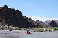
During the temperate months of March and April, given good rains and the sluices of the dams being open, a canoeist (or rafter) can easily travel 30 km per day. The lower reaches of the river are most popular, because of the spectacular topography. Commercial tours are available, and these expeditions depart from the border town of Vioolsdrif.
Wildlife
Fish species
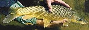
The Orange River has a relative paucity of species diversity. A 2011 survey of 13,762 fish found only 16 species of fish present.[13] Three of these, the common carp, the Mozambique tilapia, and the western mosquitofish are not indigenous.[13] Another exotic species, rainbow trout, is found in the river headwaters in Lesotho.
Seven species are endemic to the Vaal-Orange River system:[13]
- Rock-catfish (Austroglanis sclateri)
- Maloti minnow (Pseudobarbus quathlambae)
- Namaqua barb (Barbus hospes)
- River sardine (Mesobola brevianalis)
- Smallmouth yellowfish (Labeobarbus aeneus)
- Largemouth yellowfish (Labeobarbus kimberlyensis)
- Orange River Mudfish (Labeo capensis)
Larger animals
The Orange River has no large animals. It lies outside the range of the Nile crocodile, and although hippopotami were once abundant, they were hunted to extermination in the 1800s.[14]
See also
- List of rivers in South Africa
- List of international border rivers
- List of crossings of the Orange River
- Dams on the Orange River (or tributaries)
- Waterfalls on the Orange River
- Augrabies Falls
- Twin Falls
References
- ↑ Key rivers of South Africa Archived 10 July 2012 at Archive.is
- ↑ Swanevelder, C. J. (1981), Utilising South Africa's largest river: The physiographic background to the Orange River scheme, GeoJournal vol 2 supp 2 pg 29-40
- ↑ Revenga, C.; Murray, S.; Abramovitz, J. and Hammond, A . (1998) Watersheds of the world: Ecological value and vulnerability, World Resources Institute, ISBN 1-56973-254-X
- ↑ "Orange River Mouth". Ramsar Sites Information Service. Retrieved 25 April 2018.
- ↑ "Orange River Mouth". Ramsar Sites Information Service. Retrieved 25 April 2018.
- ↑ Travel, Wild Africa. "Wild Africa Travel: Orange River". www.wildafricatravel.com. Retrieved 2016-12-03.
- ↑ "Orange River Basin". www.dwa.gov.za. Retrieved 2016-12-03.
- 1 2 3 4 5 Earle, Anton et al. (2005), A preliminary basin profile of the Orange/Senqu River (pdf), African Centre for Water Research, retrieved 30 June 2007
- ↑ The Northern Ephemeral Rivers of the Orange-Senqu River Basin
- ↑ Tonchi, Victor L., William A. Lindeke, and John J. Grotpeter, "Groote Rivier" Historical Dictionary of Namibia. 2nd edition. Toronto: The Scarecrow Press, Inc, p. 154.
- ↑ Staff Reporter, "New name looms for NC River", Diamond Fields Advertiser 13 June 2013, page 11
- 1 2 Statement by Afriforum on proposed name change of Orange River
- 1 2 3 Ramollo, P. P. (2011). "Freshwater Fish Abundance and Distribution in the Orange River, South Africa". Journal of Fisheries International. 6: 13–14. doi:10.3923/jfish.2011.13.17.
- ↑ G.C. Shortridge (1934). The mammals of South West Africa. William Heinemann Ltd.
Further reading
- Thomas Kruchem: Orange~Senqu. Artery of Life. Deutsche Gesellschaft für internationale Zusammenarbeit (GIZ), Eschborn, Germany 2012, ISBN 978-3-86099-884-7.
External links
| Wikimedia Commons has media related to Orange River. |
- Orange-Senqu River Commission (ORASECOM)
- Orange-Senqu River Awareness Kit - knowledge hub for the Orange-Senqu River basin
- Map of the Orange River basin at Water Resources eAtlas
- Map of portion of Orange River basin forming part of South Africa
- Information on the Orange River from the South African Department of Water Affairs and Forestry