Norwich, Connecticut
| Norwich, Connecticut | ||
|---|---|---|
| City | ||
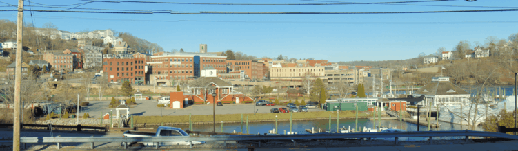
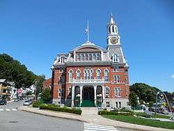 A view of the Norwich City Hall | ||
| ||
| Nickname(s): The Rose Of New England | ||
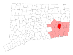 Location in New London County, Connecticut | ||
| Coordinates: 41°33′01″N 72°05′15″W / 41.55028°N 72.08750°WCoordinates: 41°33′01″N 72°05′15″W / 41.55028°N 72.08750°W | ||
| Country | United States | |
| State | Connecticut | |
| NECTA | Norwich-New London | |
| Region | Southeastern Connecticut | |
| Settled | 1659 | |
| Incorporated (city) | 1784 | |
| Consolidated | 1952 | |
| Government | ||
| • Type | Council-manager | |
| • City council |
| |
| • City manager | John Salomone | |
| Area | ||
| • City | 29.5 sq mi (76.4 km2) | |
| • Land | 28.3 sq mi (73.4 km2) | |
| • Water | 1.1 sq mi (3.0 km2) | |
| • Urban | 123.1 sq mi (318.7 km2) | |
| Elevation | 56 ft (17 m) | |
| Population (2010)[2] | ||
| • City | 40,493 | |
| • Estimate (2016)[3] | 39,556 | |
| • Density | 1,290/sq mi (499/km2) | |
| • Metro | 274,055 | |
| Time zone | UTC−5 (Eastern) | |
| • Summer (DST) | UTC−4 (Eastern) | |
| ZIP code | 06360, 06365, 06380 | |
| Area code(s) | 860 | |
| FIPS code | 09-56200 | |
| GNIS feature ID | 0209410 | |
| Website | http://www.norwichct.org/ | |

Norwich, known as 'The Rose of New England', is a city in New London County, Connecticut, United States. The population was 40,493 at the 2010 United States Census. Three rivers, the Yantic, the Shetucket, and the Quinebaug, flow into the city and form its harbor, from which the Thames River flows south to Long Island Sound.
History
Norwichtown was founded in 1659, by settlers from Old Saybrook led by Major John Mason and Reverend James Fitch.[4] They purchased the land "nine miles square" that would become Norwich from the local Native Mohegan Sachem Uncas.[5] In 1668, a wharf was established at Yantic Cove. Settlement was primarily in the three-mile (4.8 km) area around the Norwichtown Green. The 69 founding families soon divided up the land in the Norwichtown vicinity for farms and businesses.
By 1694, the public landing built at the head of the Thames River allowed ships to offload goods at the harbor; the harbor area is known as the Chelsea neighborhood. The distance between the port and Norwichtown was serviced by the East and West Roads, which later became Washington Street and Broadway.
The original center of the town was a neighborhood now called Norwichtown, an inland location chosen to be the center of a primarily agricultural farming community. By the latter 18th century, shipping at the harbor began to become far more important than farming, especially when industrial mills began manufacturing on the three smaller rivers.
By the early 19th century, the center of Norwich had effectively moved to the Chelsea neighborhood. The official buildings of the city were located in the harbor area, such as the City Hall, courts, and post office, and all the large 19th-century urban blocks. The former center is now called Norwichtown to distinguish it from the current city.
Norwich merchants were shipping goods directly from England, but the Stamp Act of 1764 forced Norwich to become more self-sufficient. Soon large mills and factories sprang up at the falls on the rivers which traverse the town. The ship captains of Norwich and New London who were skillful at avoiding Imperial taxation during peacetime later were just as successful eluding warships during war.
During the American Revolution Norwich supported the cause for independence by supplying soldiers, ships, and munitions. Norwich was also a center for activity for the Sons of Liberty. Colonial era less noteworthies include Christopher Leffingwell, and Daniel Lathrop.
The Oxford English Dictionary attests the first recorded use of the term "Hello" to The Norwich Courier on 18 October 1826.[6]
Regular steamship service between New York and Boston helped Norwich to prosper as a shipping center through the early part of the 19th century. During the Civil War, Norwich once again rallied and saw the growth of its textile, armaments, and specialty item manufacturing. This was also spurred by the building of the Norwich and Worcester Railroad in 1832–1837 bringing goods and people both in and out of Norwich. By the 1870s the Springfield and New London Railroad was also running trains through Norwich.
Geography
According to the United States Census Bureau, the city has a total area of 29.5 square miles (76.4 km2), of which 28.3 sq mi (73.4 km2) is land and 1.2 sq mi (3.0 km2) (3.87%) is water.
Climate
| Climate data for Groton–New London Airport (GON) (1981–2010), snow data from Norwich, Connecticut (1981–2010). | |||||||||||||
|---|---|---|---|---|---|---|---|---|---|---|---|---|---|
| Month | Jan | Feb | Mar | Apr | May | Jun | Jul | Aug | Sep | Oct | Nov | Dec | Year |
| Record high °F (°C) | 65 (18) |
67 (19) |
78 (26) |
88 (31) |
91 (33) |
95 (35) |
101 (38) |
99 (37) |
93 (34) |
83 (28) |
75 (24) |
69 (21) |
101 (38) |
| Average high °F (°C) | 37.5 (3.1) |
40 (4) |
46.5 (8.1) |
55.4 (13) |
64.5 (18.1) |
73.3 (22.9) |
78.2 (25.7) |
78.4 (25.8) |
72.3 (22.4) |
61.5 (16.4) |
53 (12) |
42.4 (5.8) |
58.6 (14.8) |
| Daily mean °F (°C) | 29.5 (−1.4) |
32 (0) |
37.8 (3.2) |
47 (8) |
56 (13) |
65.4 (18.6) |
70.6 (21.4) |
70.4 (21.3) |
63.7 (17.6) |
52.7 (11.5) |
44.5 (6.9) |
34.7 (1.5) |
50.4 (10.1) |
| Average low °F (°C) | 21.6 (−5.8) |
23.9 (−4.5) |
29.1 (−1.6) |
38.7 (3.7) |
47.6 (8.7) |
57.6 (14.2) |
62.9 (17.2) |
62.3 (16.8) |
55.1 (12.8) |
43.9 (6.6) |
35.9 (2.2) |
27 (−3) |
42.1 (5.6) |
| Record low °F (°C) | −14 (−26) |
−12 (−24) |
0 (−18) |
14 (−10) |
30 (−1) |
38 (3) |
47 (8) |
41 (5) |
29 (−2) |
22 (−6) |
8 (−13) |
−10 (−23) |
−14 (−26) |
| Average precipitation inches (mm) | 3.27 (83.1) |
2.86 (72.6) |
4.16 (105.7) |
4.41 (112) |
3.85 (97.8) |
4.11 (104.4) |
3.77 (95.8) |
4.16 (105.7) |
4 (100) |
3.86 (98) |
4.31 (109.5) |
3.73 (94.7) |
46.49 (1,179.3) |
| Average snowfall inches (cm) | 8.8 (22.4) |
8.0 (20.3) |
3.6 (9.1) |
0.8 (2) |
0 (0) |
0 (0) |
0 (0) |
0 (0) |
0 (0) |
0 (0) |
0.2 (0.5) |
6.6 (16.8) |
28 (71.1) |
| Average precipitation days (≥ 0.05) | 6 | 5 | 6 | 7 | 8 | 8 | 6 | 6 | 6 | 7 | 7 | 7 | 79 |
| Average snowy days (≥ 0.05) | 3 | 3 | 2 | 0 | 0 | 0 | 0 | 0 | 0 | 0 | 0 | 2 | 10 |
| Source: [7][8] | |||||||||||||
Neighborhoods
Several Norwich neighborhoods maintain independent identities and are recognized by official signs marking their boundaries. Neighborhoods of Norwich are Norwichtown, Bean Hill, Yantic, Taftville, Greeneville, Occum, East Great Plains, Thamesville, Laurel Hill and Chelsea (the original "downtown" area.)
Demographics
| Historical population | |||
|---|---|---|---|
| Census | Pop. | %± | |
| 1800 | 3,476 | — | |
| 1810 | 2,976 | −14.4% | |
| 1820 | 2,983 | 0.2% | |
| 1830 | 3,135 | 5.1% | |
| 1840 | 4,200 | 34.0% | |
| 1850 | 6,139 | 46.2% | |
| 1860 | 14,048 | 128.8% | |
| 1870 | 16,653 | 18.5% | |
| 1880 | 15,112 | −9.3% | |
| 1890 | 16,156 | 6.9% | |
| 1900 | 17,251 | 6.8% | |
| 1910 | 20,367 | 18.1% | |
| 1920 | 22,304 | 9.5% | |
| 1930 | 23,021 | 3.2% | |
| 1940 | 23,652 | 2.7% | |
| 1950 | 23,429 | −0.9% | |
| 1960 | 38,506 | 64.4% | |
| 1970 | 41,739 | 8.4% | |
| 1980 | 38,074 | −8.8% | |
| 1990 | 37,391 | −1.8% | |
| 2000 | 36,117 | −3.4% | |
| 2010 | 40,493 | 12.1% | |
| Est. 2016 | 39,556 | [3] | −2.3% |
| Population 1756–2010[9][10][11] | |||
As of the census[12] of 2000, there were 36,117 people, 15,091 households, and 9,069 families residing in the city. The population density was 1,274.7 people per square mile (492.2/km2). There were 16,600 housing units at an average density of 585.9 per square mile (226.2/km2).
Twenty-nine percent of households had children under the age of 18 living with them, 40.7% were married couples living together, 15.0% had a female householder with no husband present, and 39.9% were non-families. Thirty-two percent of all households were made up of individuals and 12.5% had someone living alone who was 65 years of age or older. The average household size was 2.34 and the average family size was 2.96.
In the city, the age distribution of the population shows 24.1% under the age of 18, 8.9% from 18 to 24, 30.2% from 25 to 44, 21.5% from 45 to 64, and 15.4% who were 65 years of age or older. The median age was 37 years. For every 100 females, there were 90.5 males. For every 100 females age 18 and over, there were 87.3 males.
In 2012, the population had risen to 40,502 and the racial makeup of the city was 70% White, 13% Hispanic or Latino, 10% Black or African American, 8% Asian, and 1% Native American. A significant influx of Chinese Americans has settled in Norwich since 2010.
The 2012 median income for a household in the city was $51,300. Fifteen percent of the population were below the poverty line.
Sports
The AA Eastern League Connecticut Defenders, previously the Norwich Navigators, were a farm team of the San Francisco Giants and they played at Senator Thomas J. Dodd Memorial Stadium from both's inception in 1995 until the team announced its move to Richmond, Virginia for the 2010 season, where they are now known as the Richmond Flying Squirrels. However, starting in 2010, Dodd Stadium became the home to the Connecticut Tigers in the Class-A short-season New York–Penn League (formerly the Oneonta Tigers). The ESPN mini-series The Bronx Is Burning was filmed at Dodd Stadium.
Parks and recreation
Mohegan Park
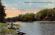
This forested area is Norwich's largest park. The park's property contains numerous hiking and biking trails, picnic tables, grills, pavilions for rent, a beach, basketball courts, a Mohegan monument, fountain and playgrounds. The Rose Garden at the entrance on Judd Road contains over a hundred varieties of roses and is a popular site for weddings. Many of the hiking trails are used by the Norwich Free Academy cross country team for practices, and in 2006 the team volunteered to improve the condition of trails. 5K "fun runs" are held in the park on Thursdays during the summer. As of 2009, the running course has been redesigned to incorporate much of the trails.
The Park Center contains Spaulding Pond, the square, fountain, and Mohegan monument, both playgrounds and a dog pound run by the Norwich Police Department. The Park Center has declined somewhat. The zoo, reptile house, and concession stand have been closed for over a decade. However, much has been done to improve the appearance of the remaining park.
Spaulding Pond, the main body of water in Mohegan Park, is held back by an earthworks dam, across which is a path bordered by pergulas and flowering plants. On March 6, 1963, long-term saturation of the over-100-year-old earthen content, along with unchecked shrub and tree growth, severely weakened the structural content of the dam and caused the waters of Spaulding Pond to burst forth into the city, causing the Great Flood of Norwich, elegantly chronicled in the 2013 book A Swift and Deadly Maelstrom; The Great Norwich Flood of 1963. The break and subsequent flood flow pulverized houses with its large ice content, over-ran streets and cars while destroying the eastern half of the Turner-Stanton Mill, situated in the flood's direct path on Centennial Square. It was there that the building collapsed, claiming the lives of six of the seven total who would die that night while causing over six million dollars in damage. Mohegan Park also contains another, smaller pond, called The Skating Pond which is southeast of the main pond. This pond, which had always been designed as an overflow spillway for Spaulding Pond and, when frozen in the winter provided a wonderful ice skating area for the local youth, thus its sobriquet, was re-designed as part of Norwich's long-term flood plan in 1968 and currently still serves as a surge overflow volume for the upgraded Spaulding Pond Dam, although it is no longer open for public use.[13]
Because of its ample, sprawling trails and variety of flora and fauna, Mohegan Park is a lesser-known destination for southeastern Connecticut's nature photographers.
Ice rink
The Norwich Municipal Ice Rink has a 200' × 85' National Hockey League regulation ice surface, four large locker rooms and other amenities. Established in 1995, the Rose City Warriors are Norwich's Senior Women's Ice Hockey Team and a number of local high school ice hockey teams call the Rink home as well.
Museum
The Slater Memorial Museum, located on the campus of the Norwich Free Academy, is named for John Fox Slater (1815−1884), corporator of The Norwich Free Academy for twenty years. The museum has grown to include the "Art of Five Continents"—North and South America, Europe, Asia, and Africa. Of particular interest are the Vanderpoel Collection of Asian Art, the Paul Zimmerman Collection of African and Oceanic Art, and a collection of 19th-century American paintings.
Gallery
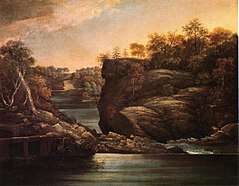 Norwich Falls, oil on canvas, John Trumbull, 1806
 Union Square, 1908
 Lake, looking north, circa 1909
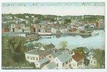
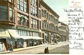 Downtown, circa 1910
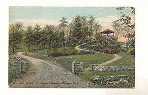 Pavilion at entrance to park, circa 1911
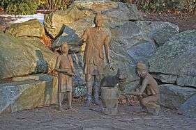 Mohegan Heritage Sculpture
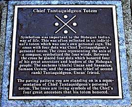 Chief Tantaquidgeon's personal Totem, commemorated on a plaque
Government
The city elects a Mayor, who presides over the City Council, which includes six other members, all elected at large. The Mayor serves a maximum of two four-year terms; the council members serve two-year terms. The council appoints the Town and City Clerk, a City Manager who acts as chief executive officer of the city government, the city Planning Commission, and Zoning Board of Appeals.[14]
Education
Elementary and middle school residents are zoned to Norwich Public Schools.[15] The middle schools of Norwich are Teachers' Memorial Middle School and Kelly Middle School. Norwich is also home to the Integrated Day Charter School, an alternative to the area of public schools.
The Norwich Free Academy is the primary high school for students living in Norwich and several surrounding towns. The Norwich Free Academy was incorporated in 1855 by an act of the Connecticut Legislature, and operates as a privately endowed independent school governed by its Board of Trustees and funded by private, municipal, and state sources. In 2006, Sidney Frank donated $12 million to the Norwich Free Academy[16] which resulted in the campus's newest building being named after him: the Sidney E. Frank Center for Visual and Performing Arts.
Norwich Technical High School, A Connecticut Technical High School System School, also serves the area. This school is a public option to those within the Norwich area, and many other towns surrounding Norwich. To those within the Norwich area, transportation is provided by Norwich Public Schools via the same buses that serve Norwich Free Academy in the morning, and in the afternoon students are transported to Norwich Free Academy to use their buses to return home.
Three Rivers Community College also serves the region.[17]
Infrastructure
Transportation
Public Transportation in Norwich is provided by Southeast Area Transit, or SEAT. The city was formerly served by various railroads in the past,
Notable people
- Benedict Arnold (1741–1801), born in Norwich, American Revolutionary War general and later British defector; a commemorative plaque is on the lot where his house used to stand; city library has a prominent portrait of Arnold on its north wall[18]
- Hannah Arnold (1708–1758), born in Norwich, mother of Benedict Arnold
- Isaac Backus (1724–1806), a delegate to the First Continental Congress, born in the city
- Isaac H. Bromley (1833–1899), born in Norwich; lawyer, editor, politician, railroad director, and humorist
- William Alfred Buckingham (1804–1875), Mayor of Norwich, 41st governor of Connecticut, and United States Senator
- Oliver A. Caswell, Wisconsin politician, born in the city
- Benjamin Church (1734–1776), surgeon general of the Continental Army, suspected of spying for the British, was confined in the city
- Richard Falley Cleveland (1804–1853), born and raised in Norwich, Christian minister known as the father of President Grover Cleveland
- Margaret Coit (1919–2003), historian, born in the city
- Erastus Corning (1794–1872), businessman and politician, born in the city
- Rajai Davis (1980–), Major League Baseball outfielder
- Roger Wilson Dennis (1902–1996), American plein air impressionist painter and art conservator
- Costa Dillon (1953–) filmmaker, creator of Attack of the Killer Tomatoes.
- Thomas J. Dodd (1907–1971), U.S. Senator and Representative; father of U.S. Senator Christopher J. Dodd, was born in the city
- Arielle Dombasle (born Arielle Sonnery de Fromental in 1958 in Norwich), singer and actress working mostly in French films
- Terence P. Finnegan (1904–1990), Chief of Chaplains of the U.S. Air Force
- Lafayette S. Foster (1806–1880), U.S. Senator and 57th President Pro Tempore of the United States Senate; died in the city
- Jonas Galusha (1753–1834), Governor of Vermont for two terms in the early 19th century; born in the city[19]
- Charlotte Perkins Gilman (1860–1935), author and social reformer, lived for a short time in the city
- Daniel Coit Gilman (1831–1908), educator, college president, foundation president
- Roger Griswold (1762–1812), Governor of Connecticut, practiced law for a time in Norwich
- Galusha A. Grow (1822–1907), speaker of the U.S. House of Representatives from 1861 to 1863, studied law in the city
- Benjamin Hanks (1755–1824), goldsmith, instrument maker, first maker of bronze cannons and church bells in America
- Benjamin Huntington (1736–1800), delegate to the Continental Congress and later a Congressman, resident of the city
- Ebenezer Huntington (1754–1834), member of the United States House of Representatives, 1817–1819
- Samuel Huntington (1731–1796), delegate to the Second Continental Congress and signer of the Declaration of Independence; first President of the United States, under the Articles of Confederation
- Samuel Kirkland (1741–1808), Presbyterian missionary among the Oneida and Tuscarora people; founder (in 1793) of the Hamilton-Oneida Academy (later Hamilton College), was born in the city
- Paul Konerko (1976–), Major League Baseball player
- Wally Lamb (1950–), author of She's Come Undone and I Know This Much Is True; director of the Writing Center at the Norwich Free Academy in the city from 1989 to 1998
- Edwin H. Land (1909–1991), inventor of the Polaroid camera
- Cato Mead (ca. 1761–1846), African-American Revolutionary War veteran
- Miantonomoh (1565?–1643), chief of the Narraganset tribe, captured and executed by the Mohegan chief Uncas with a tomahawk in Norwich
- Elisha Perkins (1741–1799), popular quack doctor whose magnetic therapy "Perkins Tractors" (made up of two 3-inch (76 mm) steel and brass rods with points at the ends) convinced even George Washington to buy a set
- Simeon Perkins (1735–1812), Nova Scotia merchant, diarist, and politician; outfitted Loyalist privateers during the American War for Independence; born and raised in this city until moving to Liverpool, Nova Scotia with the New England Planters
- Bela Pratt, sculptor, born in Norwich in 1867
- E. Annie Proulx, journalist and author; born in 1935 in the city
- Edith Roosevelt (1861–1948), second wife of Theodore Roosevelt, born in the city
- William Albert Setchell (1864–1943), botanist and UC Berkeley professor, born in the city
- Matt Shaughnessy (1986-), football defensive end for the Oakland Raiders of the National Football League, graduate of Norwich Free Academy
- Charles Sholes (1816–1867), Wisconsin politician, born in the city
- Lydia Sigourney (1791–1865), extremely popular poet from the early-to-mid-19th century, born in the city
- John Fox Slater (1815–1884), industrialist and philanthropist, founder of million-dollar Slater Fund for the Education of the Southern Freedmen in 1882
- Horace Smith (1808–1893), partnered with Daniel B. Wesson in Norwich in the early 1850s to develop the first repeating rifle, known as the Volcanic rifle; the two founded Smith & Wesson in 1852
- Albert H. Tracy (1793–1859), former US Congressman
- Phineas L. Tracy (1786–1876), former US Congressman
- John T. Wait (1811–1899), Connecticut politician and lawyer, U.S. Representative from 1876 to 1887
- Henry S. Walbridge (1801–1869), former US Congressman
- Daniel B. Wesson (1825–1906), firearm designer; see Horace Smith
- William Woodbridge (1780–1861), Governor of Michigan, also represented the state in the U.S. Senate, was born in the city
See also
References
- ↑ . City of Norwich, Connecticut http://www.norwichct.org/313/Mayor-City-Council. Retrieved 2018-05-29. Missing or empty
|title=(help) - ↑ "City Of Norwich Population Estimates". Archived from the original on 2014-07-10.
- 1 2 "Population and Housing Unit Estimates". Retrieved June 9, 2017.
- ↑ Caulkins, Frances Manwaring (1866). History of Norwich. [Hartford] Self-published.
- ↑ "Norwich, CT - Official Website - History of City". www.norwichct.org. Retrieved 2016-03-13.
- ↑ Oxford English Dictionary: hello, int. and n.
- ↑ "NOWData-NOAA Online Weather Data". Applied Climate Information System. Retrieved January 24, 2017.
- ↑ "Historic Averages-New London, Connecticut". The Weather Company. Retrieved January 24, 2017.
- ↑ "Office of the Secretary of the State". Archived from the original on 2005-09-13.
- ↑ "Archived copy". Archived from the original on 2004-06-11. Retrieved 2004-06-11.
- ↑ "Norwich city, Connecticut". U.S. Census Bureau. Retrieved October 14, 2009.
- ↑ "American FactFinder". United States Census Bureau. Retrieved 2008-01-31.
- ↑ Moody, Thomas (2013). A Swift and Deadly Maelstrom ISBN 978-1-4797-4863-1
- ↑ "City of Norwich Charter". www.municode.com. Retrieved July 12, 2007.
- ↑ "Norwich Public Schools". www.norwichpublicschools.org.
- ↑ Martin, Douglas (January 13, 2006). "Sidney E. Frank, 86; liquor baron was a master of marketing". U-T San Diego. Retrieved April 17, 2014.
- ↑ "Three Rivers Community College". www.trcc.commnet.edu.
- ↑ Who Was Who in America, Historical Volume, 1607-1896. Chicago: Marquis Who's Who. 1963.
- ↑ White, Pliny H. (October 16, 1866). Jonas Galusha, fifth governor of Vermont: A Memoir. E.P. Walton. p. 2.
External links
| Wikimedia Commons has media related to Norwich, Connecticut. |
| Wikisource has the text of a 1921 Collier's Encyclopedia article about Norwich, Connecticut. |
- Official website
- Norwich Community Development Corporation
- A Brief History of Norwich
- The Christopher Leffingwell House Museum
- Mystic Country: The Eastern Regional Tourism District
- WTNH News Article Article on Removal of the sign.

Municipalities and communities of New London County, Connecticut, United States | ||
|---|---|---|
| Cities | 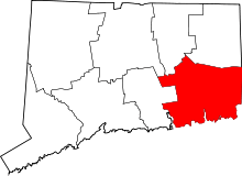 | |
| Towns | ||
| Boroughs | ||
| CDPs | ||
| Other communities | ||
| Indian reservations | ||
| Footnotes | ‡This populated place also has portions in an adjacent county or counties | |