Northern Region, Manitoba
| Northern Region | |
|---|---|
| Region | |
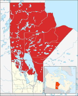 Location of Northern Manitoba in Manitoba and Canada. The thin straight lines denote census division boundaries. | |
| Country |
|
| Province |
|
| Divisions | 19, 21, 22, 23 |
| Largest city | Thompson |
| Area | |
| • Total | 438,492 km2 (169,303 sq mi) |
| Population (2011) | |
| • Total | 88,146 |
| • Density | 0.20/km2 (0.52/sq mi) |
| Time zone | UTC-6 (CST) |
| • Summer (DST) | UTC-5 (CST) |
Northern Manitoba is the most northerly region of the Canadian province of Manitoba, added to the province during the last major expansion of its boundaries in 1912.[1] Forestry, mining and hydro-electric development are significant economic drivers[2] with long-term consequences to the environment in the region.[3]
Geography
It is situated on the Canadian Shield and includes Manitoba's Hudson Bay coastline. The land area of the region is 438,491.51 km² (169,302.52 mi²), which encompasses 67% of Manitoba's total land area. The vast majority of the region is undeveloped wilderness.
Climate
Manitoba's northern region is mostly within in the subarctic climate zone (Köppen climate classification Dfc). It also has some Humid Continental (Koppen Dfb) areas in the south. This region features long and extremely cold winters and brief, warm summers with little precipitation.[4] Overnight temperatures as low as −40 °C (−40 °F) occur on several days each winter.[4]
Ecology
This region is covered by large extents of stunted Black Spruce dominant forest, with association of Tamarack. There are several mammals in the region including the Arctic fox, Beluga whale and Polar bear. The Polar bear has a significant denning area within the Wapusk National Park, from which annual bear migrations to Hudson Bay are made.[5]
Protected Areas in Northern Manitoba
A single national park, Wapusk National Park; a provincial forest, Cormorant Provincial Forest; several ecological reserves; and more than twenty provincial Parks are located in Northern Manitoba.
- Zed Lake Provincial Park and Burge Lake Provincial Park are located near the town of Lynn Lake.[6]
- Caribou River Provincial Park 59.5636°N 96.6611°W
- Clearwater Lake Provincial Park 54.08305°N 101.078333°W
- Grass River Provincial Park 54.6664°N 100.831°W
- Little Limestone Lake Provincial Park 53°46′0″N 99°20′1″W / 53.76667°N 99.33361°W[7]
- North Steeprock Lake Provincial Park 52°35′58″N 101°20′59″W / 52.59944°N 101.34972°W[8]
- Nueltin Lake Provincial Park 59°37′57″N 99°34′42″W / 59.63250°N 99.57833°W[9]
- Numaykoos Lake Provincial Park 57.865277777778°N 95.963333333333°W
- Sand Lakes Provincial Park 57.84222°N 98.53°W
- Colvin Lake Provincial Park 59°41′2″N 101°33′40″W / 59.68389°N 101.56111°W[10]
- Paint Lake Provincial Park The park is 22,740 ha (56,200 acres)[6] in size. It is located at 55°29′45″N 97°59′20″W / 55.49583°N 97.98889°W[11]
- Bakers Narrows Provincial Park The park is 145.12 ha (358.6 acres)[6] in size. It is located at 54°40′16″N 101°40′30″W / 54.67111°N 101.67500°W[12]
- Bell Lake Provincial Park The park is 3.96 ha (9.8 acres)[6] in size. It is located at 52°32′30″N 101°14′29″W / 52.54167°N 101.24139°W[13]
- Grand Rapids Provincial Park The park is 7.36 ha (18.2 acres)[6] in size. It is located at 53°8′31″N 99°17′6″W / 53.14194°N 99.28500°W[14]
- Neso Lake Provincial Park The park is 1.33 ha (3.3 acres)[6] in size. It is located at 54°39′26″N 101°32′49″W / 54.65722°N 101.54694°W[15]
- Overflowing River Provincial Park The park is 13.11 ha (32.4 acres)[6] in size. It is located at 53°8′23″N 101°5′15″W / 53.13972°N 101.08750°W[16]
- Pisew Falls Provincial Park The park is 92.86 ha (229.5 acres)[6] in size. It is located at 55°11′52″N 98°23′48″W / 55.19778°N 98.39667°W[17]
- Red Deer River Provincial Park The park is 1 ha (2.5 acres)[6] in size. It is located at 52°53′28″N 101°1′32″W / 52.89111°N 101.02556°W[18]
- Rocky Lake Provincial Park The park is 23.94 ha (59.2 acres)[6] in size. It is located at 54°10′31″N 101°23′30″W / 54.17528°N 101.39167°W[19]
- Sasagiu Rapids Provincial Park The park is 99.6 ha (246 acres)[6] in size. It is located at 55°8′55″N 98°27′9″W / 55.14861°N 98.45250°W[20]
- Twin Lakes Provincial Park The park is 1.02 ha (2.5 acres)[6] in size. It is located at 54°39′26″N 101°28′38″W / 54.65722°N 101.47722°W[21]
- Wekusko Falls Provincial Park The park is 88.23 ha (218.0 acres)[6] in size. It is located at 54°57′35″N 99°58′19″W / 54.95972°N 99.97194°W[22]
Economy
Demographics
The region is composed of four census divisions: 19 and 21–23.[23] Its total population at the 2011 census was 88,146, which was only 7.3% of Manitoba's total population in the 2011 census. The largest municipality is the city of Thompson. Other major population centers include the city of Flin Flon and the town of The Pas. Indian reserves comprise more than 49% of the region's population. There are 54 reserves with a total population of 40,572. The largest of these are Norway House 17 and Peguis 1B.
Major communities
The following communities are within the Northern Region of Manitoba:[24]
Infrastructure
Northern Manitoba is accessed by two Provincial Trunk Highways: PTH 10 to Flin Flon and PTH 6 to Thompson, as well as a network of smaller roads.[25] These are extended in the winter by an additional network of winter roads.[26]
Northern Manitoba is served by a single rail line from Saskatchewan. CN operates the line as far as the Pas [27] Keewatin Railway operates from the Pas to Pukatawagan. Hudson Bay Railway (1997) operated the line from Flin Flon to The Pas to Churchill until 2017 when it suspended service.[28]
Air transport provides access to many northern communities with 58 airfields in the region.[29] Calm Air and Perimeter Aviation provide scheduled passenger service into larger northern communities.[30][31] Chartered bush planes land on lakes when airfields are not available.[32]
See also
- First Nations in the Northern Region of Manitoba
- Nelson River Hydroelectric Project
- Southern Manitoba
References
- C. Michael Hogan. 2008 Polar Bear: Ursus maritimus, Globaltwitcher.com, ed. N. Stromberg
- Manitoba. 2009. Manitoba Regional Profiles: Northern Region Official Site, Government of Manitoba
- Community Profile: Census Division No. 19, Manitoba; Statistics Canada
- Community Profile: Census Division No. 21, Manitoba; Statistics Canada
- Community Profile: Census Division No. 22, Manitoba; Statistics Canada
- Community Profile: Census Division No. 23, Manitoba; Statistics Canada
Line notes
- ↑ Kemp, Douglas. From Postage Stamp to Keystone. Manitoba Pageant. April 1956.
- ↑ Chuchman, George (1992). "People and Land in Northern Manitoba:The Economics of Large-Scale Resource Development in Northern Manitoba". University of Manitoba anthropology papers. 32. ISSN 0227-0072. Retrieved 21 October 2017.
- ↑ Lithman, Yngve Georg (1992). "People and Land in Northern Manitoba:Introduction". University of Manitoba anthropology papers. 32. ISSN 0227-0072. Retrieved 21 October 2017.
- 1 2 Ritter, Michael E. Subarctic Climate; 2006 [archived 25 May 2008; Retrieved 7 August 2007].
- ↑ C. Michael Hogan. 2008
- 1 2 3 4 5 6 7 8 9 10 11 12 13 A System Plan for Manitoba's Provincial Parks (PDF) (March 1998 ed.). Winnipeg: Manitoba Conservation, Parks and Natural Areas Branch. 1997. Retrieved 6 October 2017.
- ↑ "Little Limestone Lake Provincial Park". Geographical Place Names. Natural Resources Canada. Retrieved 5 October 2017.
- ↑ "North Steeprock Lake Provincial Park". Geographical Place Names. Natural Resources Canada. Retrieved 5 October 2017.
- ↑ "Nueltin Lake Provincial Park". Geographical Place Names. Natural Resources Canada. Retrieved 5 October 2017.
- ↑ "Colvin Lake Provincial Park". Geographical Place Names. Natural Resources Canada. Retrieved 5 October 2017.
- ↑ "Paint Lake Provincial Park". Geographical Place Names. Natural Resources Canada. Retrieved 5 October 2017.
- ↑ "Bakers Narrows Provincial Park". Geographical Place Names. Natural Resources Canada. Retrieved 5 October 2017.
- ↑ "Bell Lake Provincial Park". Geographical Place Names. Natural Resources Canada. Retrieved 5 October 2017.
- ↑ "Grand Rapids Provincial Park". Geographical Place Names. Natural Resources Canada. Retrieved 5 October 2017.
- ↑ "Neso Lake Provincial Park". Geographical Place Names. Natural Resources Canada. Retrieved 5 October 2017.
- ↑ "Overflowing River Provincial Park". Geographical Place Names. Natural Resources Canada. Retrieved 5 October 2017.
- ↑ "Pisew Falls Provincial Park". Geographical Place Names. Natural Resources Canada. Retrieved 5 October 2017.
- ↑ "Red Deer River Provincial Park". Geographical Place Names. Natural Resources Canada. Retrieved 5 October 2017.
- ↑ "Rocky Lake Provincial Park". Geographical Place Names. Natural Resources Canada. Retrieved 5 October 2017.
- ↑ "Sasagiu Rapids Provincial Park". Geographical Place Names. Natural Resources Canada. Retrieved 5 October 2017.
- ↑ "Twin Lakes Provincial Park". Geographical Place Names. Natural Resources Canada. Retrieved 5 October 2017.
- ↑ "Wekusko Falls Provincial Park". Geographical Place Names. Natural Resources Canada. Retrieved 5 October 2017.
- ↑ Northern Manitoba: A Benchmark Report. Thompson: Northern Manitoba Economic Development Commission. 1993.
The four census divisions numbered 19, 21, 22 and 23 are generally considered to make up northern Manitoba.
- ↑ Manitoba. 2009
- ↑ "Official Highway Map". Province of Manitoba. Manitoba Infrastructure. Retrieved 29 October 2017.
- ↑ "Winter Roads in Manitoba". Province of Manitoba. Manitoba Infrastructure. Retrieved 29 October 2017.
- ↑ "Canadian Rail Atlas: Manitoba" (PDF). Proximity. Railway Association of Canada. Retrieved 29 October 2017.
- ↑ "OmniTRAX Announces Indefinite Closure of the Hudson Bay Railway from Amery to Churchill". OmniTRAX Inc. CNW. 2017-06-09. Retrieved 2017-06-10.
- ↑ "Investing in Northern Manitoba:Transportation". Province of Manitoba. Retrieved 29 October 2017.
- ↑ "History". Calm Air. Retrieved 29 October 2017.
- ↑ "Destinations Map". www.perimeter.ca. Perimeter Aviation.
- ↑ Weir, T.R. "Manitoba". The Canadian Encyclopedia. Retrieved 29 October 2017.
External Links
Lithman, Yngve Georg; Riewe, Rick R.; Wiest, Raymond E.; Wrigley, Robert E. (1992). "People and Land in Northern Manitoba". University of Manitoba anthropology papers. 32. ISSN 0227-0072. Retrieved 21 October 2017.